Manage devices from your desktop.
Garmin Express is a computer application for easily setting up, registering and managing your Garmin device.
Stay Up to Date:
Desktop notifications and step-by-step instructions make it easy to update your devices.
Map Updates:
Get the latest detailed street maps to ensure fast, accurate navigation. Express notifies you when map updates are available and helps you install them.
Software Updates:
Express makes software updates easy to install. Get convenient desktop ...
It is currently Wed Nov 05, 2025 9:53 am
 Stickies
Site map of NaviTotal.com » Forum : NaviTotal.com
NaviTotal.com is a community where you can find all needed for your GPSGarmin Express Latest Version
Read more : Garmin Express Latest Version | Views : 6775 | Replies : 6 | Forum : Software
Garmin HomePort Version 2.3.2 - Discontinued!
Navigating waters with no visible landmarks or shallow shorelines can be a daunting task for even the most experienced navigator. Pair our HomePort trip planning software¹ with your existing BlueChart® and LakeVü data and view map details, such as underwater hazards and hidden obstacles, so you can plan a route to avoid them.
Overview
• View fishing and navigational charts from BlueChart® g2 Vision® (also compatible² with BlueChart g2 navigation charts)
• Integrated with ActiveCaptain™ ...
Overview
• View fishing and navigational charts from BlueChart® g2 Vision® (also compatible² with BlueChart g2 navigation charts)
• Integrated with ActiveCaptain™ ...
Read more : Garmin HomePort Version 2.3.2 - Discontinued! | Views : 8859 | Replies : 4 | Forum : Software
Garmin Basecamp Version 4.7.5
Make the most of your next outdoor activity, or relive the trips you’ve taken. BaseCamp lets you plan outdoor activities, organize your data and share your adventures with others.
Features
Plan a Trip:
Use BaseCamp software to plan your next hiking, biking, motorcycling, driving or off-roading trip. You can view maps, plan routes, and mark waypoints and tracks from your computer — then transfer them to your device.
• The Track Draw feature lets you ...
Features
Plan a Trip:
Use BaseCamp software to plan your next hiking, biking, motorcycling, driving or off-roading trip. You can view maps, plan routes, and mark waypoints and tracks from your computer — then transfer them to your device.
• The Track Draw feature lets you ...
Read more : Garmin Basecamp Version 4.7.5 | Views : 8287 | Replies : 11 | Forum : Software
Navcore 9.501.2 For Rider
Navcore Version 9.501.2 for Rider
Released on 17 July 2019 This update applies to: Rider (2013)
• Maintenance release.
• This update prepares your navigation device for the week number rollover in April 2019 which has an impact on GPS.
Released on 17 July 2019 This update applies to: Rider (2013)
• Maintenance release.
• This update prepares your navigation device for the week number rollover in April 2019 which has an impact on GPS.
- Hidden Content
- This board requires you to be registered and logged-in to view hidden content.
Read more : Navcore 9.501.2 For Rider | Views : 5405 | Replies : 10 | Forum : > Navcores 9 for TomTom Devices
WNRO GL1 Clock Error/Sat Fixes Workaround
A lot of people who have older devices (Rider, One XL, One 3rd Edition etc) are now experiencing problems with their clocks showing 00:00 and also getting satellite fixes after the well publicized WNRO (GPS World Number Rollover) event on 6th April 2019. The problem is due to the GL1 chip on the circuit board of these devices and it is non-replaceable.
However, I have been working on a possible fix for this problem and ...
However, I have been working on a possible fix for this problem and ...
Read more : WNRO GL1 Clock Error/Sat Fixes Workaround | Views : 29257 | Replies : 82 | Forum : Tutorials
New Navcore v9.541 released for many NAV2's
https://uk.support.tomtom.com/app/relea ... ype/navkit :-
VERSION 9.541
Released on 19 December 2018 This update applies to: XXL Classic, ONE IQ Routes, XL IQ Routes, XL IQR2 / XL Classic, GO 750, GO 750 LIVE, GO 950, GO 950 LIVE, GO 540 LIVE, GO 740 LIVE, GO 940 LIVE, GO 530, GO 630, GO 730, GO 930, GO 720, GO 520, GO 920, EASE, ONE 140, Start
Maintenance release.
...so ...
Read more : New Navcore v9.541 released for many NAV2's | Views : 47843 | Replies : 135 | Forum : > Navcores 9 for TomTom Devices
Worldwide COVERAGES and SEARCH
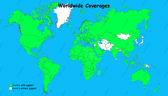
Cheers !!!
I count them; I always had a dilemma when it came to knowing which map to download for the TT, knowing that my TT had SD. And that was a limitation when it came to installing the
maps; And the toppings were different depending on the map you were downloading.
Well I have created an excel file in which almost ALL the world maps with their version, coverage, size and year of ...
Read more : Worldwide COVERAGES and SEARCH | Views : 28153 | Replies : 2 | Forum : > Maps v1XXX
WINDOWS USB Drivers software version 2.3.1.2
WINDOWS USB Drivers software version 2.3.1.2
USB Drivers software version 2.3.1.2
as of October 1, 2015
Download (9.24 MB)
Changes made from version 2.3.1.1 to 2.3.1.2:
• Updated firmware for USB programmer.

USB Drivers software version 2.3.1.2
as of October 1, 2015
- Code: Select all
http://www8.garmin.com/support/download_details.jsp?id=591

http://www8.garmin.com/support/download_details.jsp?id=592
Download (9.24 MB)
- Code: Select all
http://download.garmin.com/software/USBDrivers_2312.exe
Changes made from version 2.3.1.1 to 2.3.1.2:
• Updated firmware for USB programmer.
Read more : WINDOWS USB Drivers software version 2.3.1.2 | Views : 4140 | Replies : 0 | Forum : Software
Navigon Europe Q1/2018 Fresh Maps MN7 & MN8
Navigon Europe Q1/2018 Fresh Maps MN7 & MN8

- Hidden Content
- This board requires you to be registered and logged-in to view hidden content.
Read more : Navigon Europe Q1/2018 Fresh Maps MN7 & MN8 | Views : 10754 | Replies : 16 | Forum : Maps for Navigon
Fresh Maps North America Q32017
Fresh Maps North America Q32017


- Hidden Content
- This board requires you to be registered and logged-in to view hidden content.
Read more : Fresh Maps North America Q32017 | Views : 4289 | Replies : 6 | Forum : Maps for Navigon
Last 10 active topics
Statistics
Total posts 166130 • Total topics 17546 • Total members 689689