 Forum
ForumhI all
Can anyone help?
I tried to unlock a Navman and i got more than i bargained for .
it has a computer usb link like it needs an update and it wont change nomatter what . Does anyone have any ideas what i can do to restore it?
I had backed up the files but now all seem to be corrupted.
Help
Thanks

- Contact •
- FAQ •
- Register •
- Login
- View unanswered posts • View active topics
-
 Board index ‹ Site map ‹ News of NaviTotal.com
It is currently Sun Nov 30, 2025 9:18 am
 News of NaviTotal.com
Site map of NaviTotal.com » Forum : NaviTotal.com
NaviTotal.com is a community where you can find all needed for your GPSS80 NAVMAN UNLOCK FAIL ... hELP
Read more : S80 NAVMAN UNLOCK FAIL ... hELP | Views : 3280 | Replies : 9 | Forum : Navman Device Unlock
Traffic Camera for Phillipines
Good Day Sr/Mam
I would like to ask you how to make navitel detect traffic cams here in the philippines. i have the latest map and navitel 9.0 Thanks.
I would like to ask you how to make navitel detect traffic cams here in the philippines. i have the latest map and navitel 9.0 Thanks.
Read more : Traffic Camera for Phillipines | Views : 2475 | Replies : 1 | Forum : Navitel Navigator System
Speed Camera not available
Hi,
I have an old tomtom one 3rd edition and I updated the navcore to 9.485 and map 940.5963, I downloaded the 2015.02 speed camera files. Fastactivate successfully patched the map and speed camera file. But when I go to - Tomtom service - Speed Cameras, the icon is greyed out and I could not click on it.
Could some please help to let me know how could I enable the speed cameras? Thanks a ...
Read more : Speed Camera not available | Views : 1925 | Replies : 7 | Forum : General Discussions about TomTom
Request: iGo Maps for Costa Rica
Hey,
All the old links for costa rica or central america maps seem to be broken.
Does anyone have them please?
All the old links for costa rica or central america maps seem to be broken.
Does anyone have them please?
Read more : Request: iGo Maps for Costa Rica | Views : 3016 | Replies : 4 | Forum : Maps, buildings, dem, POI
Garmin On RoadNav S100 Double Din
Just purchased a Suzuki Grand Vitara Navigation unit which is a Roadnav S100 C053
It has Igo8 navigation but I have two questions
It says the Igo8 supports Garmin maps, how do I install these?
Also I have a genuine Garmin XT on a micro SD, could I also install XT onto the unit without deleting the Igo8?
Thanks in advance
Karl
It has Igo8 navigation but I have two questions
It says the Igo8 supports Garmin maps, how do I install these?
Also I have a genuine Garmin XT on a micro SD, could I also install XT onto the unit without deleting the Igo8?
Thanks in advance
Karl
Read more : Garmin On RoadNav S100 Double Din | Views : 2134 | Replies : 0 | Forum : General Discussions about Garmin
Garmin Nuvi 610
Having a problem updating my maps on my garmin nuvi 610. I have connected the device up to the Garmin Express app on my pc. It downloads the map updates on but wont install them because theres not enough space. I have updated the firmware but just cannot update the maps. I have even inserted an SD card but Im still getting the same error message
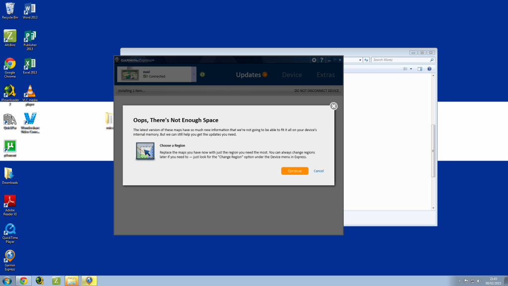
Help
Any help with this will be very ...
Help
Any help with this will be very ...
Read more : Garmin Nuvi 610 | Views : 2415 | Replies : 0 | Forum : Maps for Navigon
iGO Primo Israel 9.6.29.483387 (31 Jan 2015)
iGO Primo Israel 9.6.29.483387 (31 Jan 2015)
9.6.29.483387 /09.02
Thanks @arimi
- Hidden Content
- This board requires you to be registered and logged-in to view hidden content.
9.6.29.483387 /09.02
- Code: Select all
https://play.google.com/store/apps/details?id=com.nng.igoprimoisr.javaclient
Thanks @arimi
Read more : iGO Primo Israel 9.6.29.483387 (31 Jan 2015) | Views : 11430 | Replies : 4 | Forum : Android Apps
iGO Primo Isr_Free v9.6.29.482191 29 Jan 2015
iGO Primo Isr_Free v9.6.29.482191 29 Jan 2015
Thanks @arimi
- Hidden Content
- This board requires you to be registered and logged-in to view hidden content.
Thanks @arimi
- Code: Select all
https://play.google.com/store/apps/details?id=com.nng.igoprimoisr2013march24.javaclient&hl=en
Read more : iGO Primo Isr_Free v9.6.29.482191 29 Jan 2015 | Views : 5015 | Replies : 0 | Forum : Android Apps
bootloader 5.5022 [Solved]
hi all where can I download bootloader ver 5.5022 its for a go300 so I can use over 4gb card
Read more : bootloader 5.5022 [Solved] | Views : 1793 | Replies : 3 | Forum : General Discussions about TomTom
MAPS for WinCE system
What kind of maps do I need for IGO Primo WinCE system. Are these maps same as maps for IGO Primo for android.
Thanks in advance
Thanks in advance
Read more : MAPS for WinCE system | Views : 5671 | Replies : 2 | Forum : Maps, buildings, dem, POI
Last 10 active topics
Statistics
Total posts 166367 • Total topics 17576 • Total members 690905


