
 Forum
Forum- Contact •
- FAQ •
- Register •
- Login
- View unanswered posts • View active topics
-
 Board index ‹ Site map ‹ News of NaviTotal.com
It is currently Mon Dec 01, 2025 12:12 pm
 News of NaviTotal.com
Site map of NaviTotal.com » Forum : NaviTotal.com
NaviTotal.com is a community where you can find all needed for your GPSmp8000 sat nav disk
hi can anybody help me plz im after the satnav disk as i have bought a mitsubishi lwb 3.2did elegance and it has no disks for the satnav ?????? :022:
Read more : mp8000 sat nav disk | Views : 3198 | Replies : 0 | Forum : Mitsubishi
Garmin motormap on android
Still looking for a easy way to get routes from garmin motor map to my android.
For now I'm using ITN converter and sygic.
I think it would be nice to get an application you could directly us rhe route.
Any suggestions?
For now I'm using ITN converter and sygic.
I think it would be nice to get an application you could directly us rhe route.
Any suggestions?
Read more : Garmin motormap on android | Views : 2777 | Replies : 4 | Forum : Android Discussion
TT One hangs on asking Language
Hi there,
Wanted t upgrade my TTOne 3rd edition 1GB with bootloader 5.5022 en NC 9510 with the latest Western US and Canada map 965.7280
First I've made a backup
Then I've tried to upgrade it but after a 15sec reset the displaytext said "You can't use this map on this device".
Then I've copied the back up back to the TT but after starting up it hangs on asking language. When I touch the ...
Read more : TT One hangs on asking Language | Views : 5515 | Replies : 41 | Forum : General Discussions about TomTom
Bluechart G2 Vision VUS401S Bermuda v2015.50 (V 17.00)
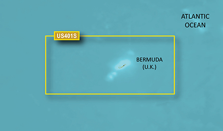
Read more : Bluechart G2 Vision VUS401S Bermuda v2015.50 (V 17.00) | Views : 2845 | Replies : 0 | Forum : New Maps
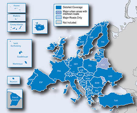
City Navigator Europe NTU 2016.30
Garmin City Navigator Europe NTU 2016.30 (UNLOCKED)
Info Upload:
Installation of the card::
Create a directory and upload Garmin map image gmapprom.img,
if the map was not visible to the device,
rename the file to gmapsupp.img
After this operation, it is best to restore the device to factory Garmin
by holding the bottom of the screen and then turn navigation, the device should
ask for the language ...
Info Upload:
- Code: Select all
File: gmapprom.img
Password: None
Data recovery: None
Installation of the card::
Create a directory and upload Garmin map image gmapprom.img,
if the map was not visible to the device,
rename the file to gmapsupp.img
After this operation, it is best to restore the device to factory Garmin
by holding the bottom of the screen and then turn navigation, the device should
ask for the language ...
Read more : City Navigator Europe NTU 2016.30 | Views : 2534 | Replies : 0 | Forum : New Maps
How to tell if updated postcodes have 'taken' ?
I've just updated my WinCE type Nav running 7.910 Navcore to use the latest UK maps and I've also followed the instructions to put the latest postcodes file on there, ('zip' file in the root of the SDcard).
How can I tell whether the updated postcodes have taken effect ? I tried searching for postcodes of new housing estates to see if they were in there, but it's not proving conclusive !
Cheers !
How can I tell whether the updated postcodes have taken effect ? I tried searching for postcodes of new housing estates to see if they were in there, but it's not proving conclusive !
Cheers !
Read more : How to tell if updated postcodes have 'taken' ? | Views : 3564 | Replies : 20 | Forum : General Discussions about TomTom
Papago 8.5 Philippines Maps
Any idea how to find Philippines maps for the PAPAGo 8.5. Im trying to use a Pioneer 2 din (AVIC 7302) Has singapore maps installed need to change to Philippines. Any help is great appreciated!!!!!!! ANy other ideas like how to install or use Garmin would be great as well.
THanks, Luke
THanks, Luke
Read more : Papago 8.5 Philippines Maps | Views : 10139 | Replies : 2 | Forum : PaPaGO! Maps
Central_America+Mexic_HERE_2015.Q4
Central_America+Mexic_HERE_2015.Q4
- Code: Select all
[size=100[b]Torrent[/b][/size]

[b]Cayman_Islands_HERE_2015.Q4_151215.fbl
Cayman_Islands_HERE_2015.Q4_151207.poi
Costa_Rica_HERE_2015.Q4_151207.poi
Costa_Rica_HERE_2015.Q4_151215.fbl
Dominican_Republic_HERE_2015.Q4_151215.fbl
Dominican_Republic_HERE_2015.Q4_160211.poi
Guadeloupe_HERE_2015.Q4_151207.poi
Guadeloupe_HERE_2015.Q4_151215.fbl
Guatemala_HERE_2015.Q4_151207.poi
Guatemala_HERE_2015.Q4_151215.fbl
Martinique_HERE_2015.Q4_151207.poi
Martinique_HERE_2015.Q4_151215.fbl
Mexico_HERE_2015.Q4_160211.fbl
Mexico_HERE_2015.Q4_160128.poi
Mexico_HERE_2015.Q4_160211_(AP).fpa
Mexico_HERE_2015.Q4_160211_(DA).fda
Mexico_HERE_2015.Q4_160211_(SP).fsp
Mexico_HERE_Easy_2015.Q4_160211.hnr
Mexico_HERE_Economic_2015.Q4_160211.hnr
Mexico_HERE_Fastest_2015.Q4_160211.hnr
Mexico_HERE_Green_2015.Q4_160211.hnr
Mexico_HERE_Shortest_2015.Q4_160211.hnr
Nicaragua_HERE_2015.Q4_151207.poi
Nicaragua_HERE_2015.Q4_151215.fbl
Panama_HERE_2015.Q4_151207.poi
Panama_HERE_2015.Q4_151215.fbl
The_Bahamas_HERE_2015.Q4_151207.poi
The_Bahamas_HERE_2015.Q4_151215.fbl [/b]
- Hidden Content
- This board requires you to be registered and logged-in to view hidden content.
Read more : Central_America+Mexic_HERE_2015.Q4 | Views : 3444 | Replies : 9 | Forum : Maps, buildings, dem, POI
Is it possible to rotate 3D Cars?
I created my own 3D car, but it's currently backwards lol. Is it possible to rotate it using a line in sys.txt or will I have to edit the model file?
Read more : Is it possible to rotate 3D Cars? | Views : 1564 | Replies : 0 | Forum : General Discussions about iGO core
Error 148 - TT services
HI,
I wondered if anyone can help please. I have a TT Go Live 750 (UK Map - patched) and i have suddenly had a Error 148 occur. I have live services for about another month. I have tried resetting, taking all files off and reinstalling Navcore 9.54.2 (by Downunder). I have also used the TT clear flash tool. I now don't appear to have an MCC/MNC number. I have tried flight mode on and ...
I wondered if anyone can help please. I have a TT Go Live 750 (UK Map - patched) and i have suddenly had a Error 148 occur. I have live services for about another month. I have tried resetting, taking all files off and reinstalling Navcore 9.54.2 (by Downunder). I have also used the TT clear flash tool. I now don't appear to have an MCC/MNC number. I have tried flight mode on and ...
Read more : Error 148 - TT services | Views : 1643 | Replies : 3 | Forum : General Discussions about TomTom
Last 10 active topics
Statistics
Total posts 166379 • Total topics 17579 • Total members 690959


