It is currently Wed Nov 05, 2025 7:30 pm
 News of New Maps
Site map of New Maps » Forum : New Maps
Garmin VietnamMap 2.04.0115
please delete - double post
Read more : Garmin VietnamMap 2.04.0115 | Views : 2046 | Replies : 0
Garmin - CityNavigator Europe NT 2015.40
Garmin - CityNavigator Europe NT 2015.40
Requirements: garmin devices, PC
Overview: Navigate the streets of Europe with confidence. This product provides detailed road maps and points of interest for your compatible device, so you can navigate with exact, turn-by-turn directions to any address or intersection. Route to restaurants, gas stations, lodging, attractions and more.
•Includes more than 10.8 million km (6.7 million mi) of roads, including motorways, national and regional thoroughfares and local roads, in ...
Read more : Garmin - CityNavigator Europe NT 2015.40 | Views : 3424 | Replies : 1
City Navigator Chile NT 2015.40
City Navigator Chile NT 2015.40
Navigate the streets with confidence. This product provides detailed road maps and points of interest for your device, so you can navigate with exact, turn-by-turn directions to any address or intersection.
Navigate the streets with confidence. This product provides detailed road maps and points of interest for your device, so you can navigate with exact, turn-by-turn directions to any address or intersection.
- Shows more than 172,000 km (107,000 mi) of roads, including motorways, national and regional thoroughfares and local roads.
- Displays more than 40,000 points of interest throughout the country, including restaurants, lodging, attractions and shopping.
- Gives turn-by-turn ...
Read more : City Navigator Chile NT 2015.40 | Views : 2248 | Replies : 0
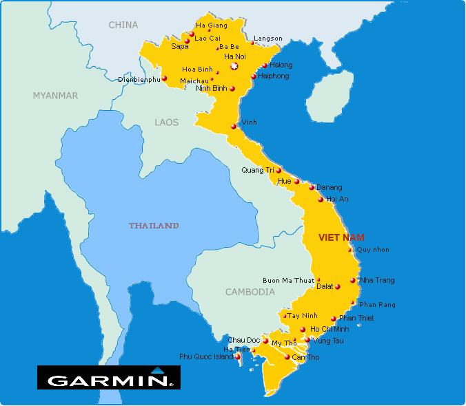
Garmin VietnamMap 2.04.0115
Garmin VietnamMap 2.04.0115
Requirements: garmin devices
Overview: routable Map of Vietnam
More Info:
Download Instructions:
inside:
unloked gmap folder
JCV file
POI files
Hoster
filefactory.com
share-online.biz
Requirements: garmin devices
Overview: routable Map of Vietnam
More Info:
- Code: Select all
http://www.garminvietnam.vn/Trang-Chu.aspx
Download Instructions:
- Hidden Content
- This board requires you to be registered and logged-in to view hidden content.
inside:
unloked gmap folder
JCV file
POI files
Hoster
filefactory.com
share-online.biz
Read more : Garmin VietnamMap 2.04.0115 | Views : 1982 | Replies : 0
Garmin - CityNavigator Europe NT(Unicode) 2015.40
Garmin - CityNavigator Europe NT(Unicode) 2015.40
Requirements: garmin devices, PC
Overview: Navigate the streets of Europe with confidence. This product provides detailed road maps and points of interest for your compatible device, so you can navigate with exact, turn-by-turn directions to any address or intersection. Route to restaurants, gas stations, lodging, attractions and more.
•Includes more than 10.8 million km (6.7 million mi) of roads, including motorways, national and regional thoroughfares and local roads, in ...
Read more : Garmin - CityNavigator Europe NT(Unicode) 2015.40 | Views : 18353 | Replies : 15
City Navigator Europe
hello
I'm from Brazil
I very much appreciate this forum and always try new it
There latest europe map the City Navigator Europe 2015.20?
I am very grateful to all
(apologies, erroneously posted and do not know how to move)
.
I'm from Brazil
I very much appreciate this forum and always try new it
There latest europe map the City Navigator Europe 2015.20?
I am very grateful to all
(apologies, erroneously posted and do not know how to move)
.
Read more : City Navigator Europe | Views : 2275 | Replies : 2
Bulgaria OFRM Geotrade 2015 Q1
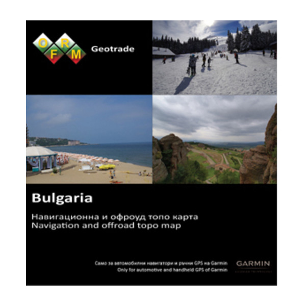
The new version 2015 Q1 is now available for download on our website all customers with an active subscription for updates. As always, we want to express special thanks to all the customers and friends who sent us information found inaccuracies in the previous version, actively helping to refine the map!
Extended coverage in settlements
Enriched information is available for search by address (street and number) with 14 new settlements.
Added new objects ...
Read more : Bulgaria OFRM Geotrade 2015 Q1 | Views : 4144 | Replies : 1
Garmin - City Navigator Australia And New Zealand NT 2015.40
Garmin - City Navigator Australia And New Zealand NT 2015.40
Requirements: compatible device
Overview: Navigate the streets with confidence. This product provides detailed road maps and points of interest for your device, so you can navigate with exact, turn-by-turn directions to any address or intersection.
• Includes nearly 1.3 million km (796,000 mi) of roads, including motorways, national and regional thoroughfares and local roads throughout Australia and New Zealand.
• Displays more than 630,000 points ...
Read more : Garmin - City Navigator Australia And New Zealand NT 2015.40 | Views : 2814 | Replies : 2
BlueChart g2 Vision VAF451S Namibia-Knysna v 16.00

Read more : BlueChart g2 Vision VAF451S Namibia-Knysna v 16.00 | Views : 1637 | Replies : 1
BlueChart g2 Vision - VAF450S - Madeira & Canary Islands 2014.5 (16.00)
BlueChart g2 Vision - VAF450S - Madeira & Canary Islands 2014.5 (16.00)
See your vessel’s precise, on-chart position in relation to navaids, coastal features and restricted areas with premium features found in this detailed marine mapping data. Includes all of the features of our BlueChart® g2 product, plus 3-D perspective above and below the waterline, Auto Guidance, high-resolution imagery, and aerial photos of ports, harbors, marinas and landmarks.
See your vessel’s precise, on-chart position in relation to navaids, coastal features and restricted areas with premium features found in this detailed marine mapping data. Includes all of the features of our BlueChart® g2 product, plus 3-D perspective above and below the waterline, Auto Guidance, high-resolution imagery, and aerial photos of ports, harbors, marinas and landmarks.
- Shaded depth contours, coastlines, spot soundings, ...
Read more : BlueChart g2 Vision - VAF450S - Madeira & Canary Islands 2014.5 (16.00) | Views : 2319 | Replies : 1
Last 10 active topics
Statistics
Total posts 166133 • Total topics 17546 • Total members 689709