 Forum
ForumOn the City Navigator North America NT 2016.10 maps previously posted , can someone please add/post the .JCV split screen file for the Garmin Nuvi 40/50 GPS. I have tried the ones posted and they don't seem to work on my unit.
Thank you.

- Contact •
- FAQ •
- Register •
- Login
- View unanswered posts • View active topics
-
 Board index ‹ Site map ‹ News of NaviTotal.com ‹ News of New Maps
It is currently Wed Nov 05, 2025 5:39 pm
 News of New Maps
Site map of New Maps » Forum : New Maps
NA 2016.10 Need JCV split screen file for NUVI 40/50
Read more : NA 2016.10 Need JCV split screen file for NUVI 40/50 | Views : 1952 | Replies : 0
For Sell: Garmin Alpha 100 GPS Training & Tracking Collar
NO SPAMMING!!!!
tendriver
Super Mod
tendriver
Super Mod
Read more : For Sell: Garmin Alpha 100 GPS Training & Tracking Collar | Views : 1493 | Replies : 0
Garmin - TrekMap Italia v4 Pro
Garmin - TrekMap Italia v4 Pro
Requirements: compatible Garmin Devices
Overview:Prepare for your next great adventure anywhere in Italy with this topographic mapping product — now enhanced with highly detailed maps for 9 Italian regions. With fully routable maps and Garmin ActiveRouting¹, it contains versatile route planning for hiking as well as climbing.
Integrates topographic data from Regional Cartography Offices at a scale of 1:10,000 to provide the latest generation of vectorized maps on compatible ...
Read more : Garmin - TrekMap Italia v4 Pro | Views : 12216 | Replies : 8
Onroute Motorkaart MiddenEuropa 2015
Onroute Motorkaart MiddenEuropa 2015
Requirements: for all Garmin Devices
Overview: As a motorcyclist you want to go as quickly as possible from A to B, but on a nice route.
Midden Europe version includet( Benelux, Germany, Austria , Switzerland , France , Italy , Spain , Portugal, England, Scotland, Wales, Ireland, Denmark, Sweden, Norway, Finland ).

• automatically finds the best motorcycle roads
• both in unit and PC
• Super easy to use ...
Requirements: for all Garmin Devices
Overview: As a motorcyclist you want to go as quickly as possible from A to B, but on a nice route.
Midden Europe version includet( Benelux, Germany, Austria , Switzerland , France , Italy , Spain , Portugal, England, Scotland, Wales, Ireland, Denmark, Sweden, Norway, Finland ).
• automatically finds the best motorcycle roads
• both in unit and PC
• Super easy to use ...
Read more : Onroute Motorkaart MiddenEuropa 2015 | Views : 3552 | Replies : 14
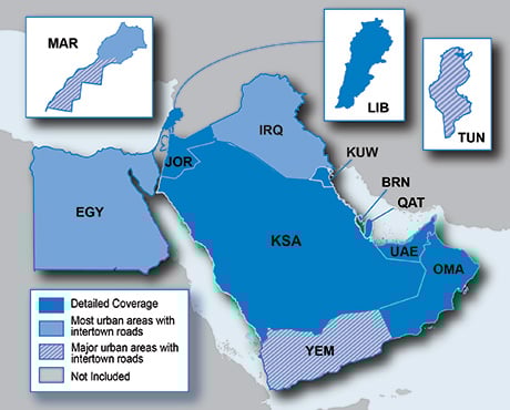
City Navigator Middle East & Northern Africa NT 2016.10
FID: 3363
MS LOCK
- Hidden Content
- This board requires you to be registered and logged-in to view hidden content.
FULL IMG.UNL
- Hidden Content
- This board requires you to be registered and logged-in to view hidden content.
JCV_G2S_db_3D_SID
- Hidden Content
- This board requires you to be registered and logged-in to view hidden content.
EAST 3D_JCV
- Hidden Content
- This board requires you to be registered and logged-in to view hidden content.
gmapdem
- Hidden Content
- This board requires you to be registered and logged-in to view hidden content.
Read more : City Navigator Middle East & Northern Africa NT 2016.10 | Views : 11963 | Replies : 7
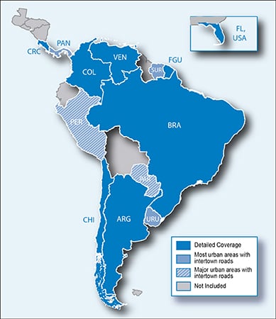
City Navigator South America NT 2016.10
FID: 3765
MS LOCK
- Hidden Content
- This board requires you to be registered and logged-in to view hidden content.
UNL.IMG/3D
- Hidden Content
- This board requires you to be registered and logged-in to view hidden content.
3490ASR
- Hidden Content
- This board requires you to be registered and logged-in to view hidden content.
SID/JCV/G2S/db
- Hidden Content
- This board requires you to be registered and logged-in to view hidden content.
BRAZIL_UNL.IMG/JCV/3D/G2S
- Hidden Content
- This board requires you to be registered and logged-in to view hidden content.
2xx9_Foursquare_files
- Hidden Content
- This board requires you to be registered and logged-in to view hidden content.
Read more : City Navigator South America NT 2016.10 | Views : 2974 | Replies : 1
City Navigator South America NT 2016.10
Image Unlocked: https://goo.gl/wsK21u
JCV High: https://goo.gl/En7oS3
Sqlite: https://goo.gl/JwqA6T
gmap3d unlocked: https://goo.gl/eL4G9E
Tks: xande4548
JCV High: https://goo.gl/En7oS3
Sqlite: https://goo.gl/JwqA6T
gmap3d unlocked: https://goo.gl/eL4G9E
Tks: xande4548
Read more : City Navigator South America NT 2016.10 | Views : 5117 | Replies : 3
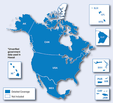
City Navigator North America NT 2016.10
FID: 3767
MS LOCK
- Hidden Content
- This board requires you to be registered and logged-in to view hidden content.
IMG.UNL
- Hidden Content
- This board requires you to be registered and logged-in to view hidden content.
3D UNL
- Hidden Content
- This board requires you to be registered and logged-in to view hidden content.
D3060180A_JCV - NA Fullscreen large JCV
D1279260A.JCV - US & CA only Fullscreen
D3191170A.JCV SplitScreen Full version Nuvi 24xx 25xx
D3153180A.jcv 13xx & 14xx Lite jcv
D3478160A.jcv Nuvi x0/x2&street pilot:LaneAssistTemplatePortrait Splitscreen Template jcv USA CAN only
D3836130A.JCV SplitScreen Full
- Hidden Content
- This board requires you to be registered and logged-in to view hidden content.
SID
- Hidden Content
- This board requires you to be registered and logged-in to view hidden content.
D2329210A_G2S
- Hidden Content
- This board requires you to be registered and logged-in to view hidden content.
D3397160A_db
- Hidden Content
- This board requires you to be registered and logged-in to view hidden content.
D3838120A_gpi
- Hidden Content
- This board requires you to be registered and logged-in to view hidden content.
Foursquare IMG/SID
- Hidden Content
- This board requires you to be registered and logged-in to view hidden content.
Read more : City Navigator North America NT 2016.10 | Views : 20891 | Replies : 27
City Navigator Europe NTU 2016.10
City Navigator Europe NTU 2016.10
FID: 3758
Map source data with .msi installer:
Image ALL: (Made with MapInstall)
FID: 3758
Map source data with .msi installer:
Image ALL: (Made with MapInstall)
Read more : City Navigator Europe NTU 2016.10 | Views : 27587 | Replies : 14
BlueChart g2 Vision - VUS004R - New York 2014.5 (16.00)
BlueChart g2 Vision - VUS004R - New York 2014.5 (16.00)
See your vessel’s precise, on-chart position in relation to navaids, coastal features, restricted areas and more with premium features found in this detailed marine mapping data. Includes all of the BlueChart® g2 features, plus 3-D perspective above and below the waterline, Auto Guidance, high-resolution imagery, and aerial photos of ports, harbors, marinas, landmarks and other points of interest.
See your vessel’s precise, on-chart position in relation to navaids, coastal features, restricted areas and more with premium features found in this detailed marine mapping data. Includes all of the BlueChart® g2 features, plus 3-D perspective above and below the waterline, Auto Guidance, high-resolution imagery, and aerial photos of ports, harbors, marinas, landmarks and other points of interest.
- Includes realistic navigation features showing everything ...
Read more : BlueChart g2 Vision - VUS004R - New York 2014.5 (16.00) | Views : 2671 | Replies : 2
Last 10 active topics
Statistics
Total posts 166131 • Total topics 17546 • Total members 689706


