
 Forum
Forum- Contact •
- FAQ •
- Register •
- Login
- View unanswered posts • View active topics
-
 Board index ‹ Site map ‹ News of NaviTotal.com ‹ News of New Maps
It is currently Wed Nov 05, 2025 2:50 pm
 News of New Maps
Site map of New Maps » Forum : New Maps
Mercedes ngt2 2015 map, anyone?
Looking for new maps, anyone can help?
Read more : Mercedes ngt2 2015 map, anyone? | Views : 1532 | Replies : 0
Garmin - AdriaROUTE 4.40 NT
Garmin - AdriaROUTE 4.40 NT
Requirements: for all Garmin Devices
Overview:Navigate the streets of southeast Europe with confidence. This product provides detailed road maps and points of interest for your compatible device, so you can navigate with exact, turn-by-turn directions to any address or intersection.
Includes 230,000 km (145,000 mi) of roads, including motorways, national and regional thoroughfares and local roads.
Displays more than 100,000 points of interest, including restaurants, hotels, gas stations, hospitals, ...
Read more : Garmin - AdriaROUTE 4.40 NT | Views : 4698 | Replies : 1
no one link works
Why all link doesn't work in this forum? some people check some time the link???
Read more : no one link works | Views : 1615 | Replies : 4
City Navigator North America NT 2016.10 ORIGINAL
City Navigator North America NT 2016.10 ORIGINAL
CNNA map has been revised by Garmin before releasing it to public
FID: 3767
Original MapSource with .msi installer:
Original Image ALL:
3D:
CNNA map has been revised by Garmin before releasing it to public
FID: 3767
Original MapSource with .msi installer:
Original Image ALL:
3D:
Locked: Download
UnLocked: ...
Read more : City Navigator North America NT 2016.10 ORIGINAL | Views : 6395 | Replies : 12
City Navigator Australia & New Zealand NT 2016.10 Sensis
City Navigator Australia & New Zealand NT 2016.10 Sensis
FID: 3947
Map Source Data with .msi installer:
Image: ALL
3D:
FID: 3947
Map Source Data with .msi installer:
Image: ALL
Locked: Download
UnLocked: Download
- Code:
File:      G:\Garmin\gmapprom.img, length 272457728
Header:      01.08.2015 12:33:37, DSKIMG, XOR 00, V 20.16, Ms 0, D124118AG036
Mapset:      CN Aus & NZ NT 2016.10 ALL

Data MPS
 V: CN Aus & NZ NT 2016.10 ALL (0)
 U: 00000-00000-00000-00000-00000
 F: PID 1, FID 3947, CN Aus & NZ NT 2016.10
3D:
Locked: ...
Read more : City Navigator Australia & New Zealand NT 2016.10 Sensis | Views : 4624 | Replies : 5
Garmin - City Navigator Russia NT 2016.20 Navicom
Garmin - City Navigator Russia NT 2016.20 Navicom
Requirements: garmin devices, PC
Overview:Coverage maps "Roads of Russia." Includes the territory of Russia, Ukraine, Abkhazia and the Republic of Belarus.
All regions of Russia with a detailed coverage. 191 868 settlements with address search. More than 7 300 settlements with the contours of homes and address search
For Ukraine, Abkhazia and the Republic of Belarus cards contain federal highways and detailed information about the places of ...
Read more : Garmin - City Navigator Russia NT 2016.20 Navicom | Views : 4113 | Replies : 1
Auto Drive Hellas 4.10T
Auto Drive Hellas 4.10T
July 22, 2015
AutoDrive Hellas is a detailed road map especially designed for Garmin navigation devices. Its unbeatable coverage in conjunction with regular updates make it the most comprehensive solution for navigation in Greece, both within and outside the city. It is the only map that combines detailed coverage of cities and villages throughout Greece, with information on dirt roads, mountain peaks, beaches.
- Includes Athens greater area, Piraeus and Thessaloniki, all ...
Read more : Auto Drive Hellas 4.10T | Views : 4209 | Replies : 4
Garmin - CityNavigator South America NT 2016.20
Garmin - CityNavigator South America NT 2016.20
Requirements: garmin devices, PC
Overview:Navigate the streets with confidence. This product provides detailed road maps and points of interest for your device, so you can navigate with exact, turn-by-turn directions to any address or intersection.
Includes millions of roads throughout 12 South American countries and Florida in the U.S.
Displays millions of points of interest, including restaurants, lodging, attractions and shopping.
Gives turn-by-turn directions on compatible devices.
Speaks ...
Read more : Garmin - CityNavigator South America NT 2016.20 | Views : 7294 | Replies : 8
Garmin City Navigator North America 2016.10
I have this map .img and I would like to put it on a SD card for my Kenwood DNN770HD. . .but I need .asr and .srx files. This is my first time trying to update this Kenwood and I really need some help!
Thank you in advance!
Thank you in advance!
Read more : Garmin City Navigator North America 2016.10 | Views : 4351 | Replies : 6
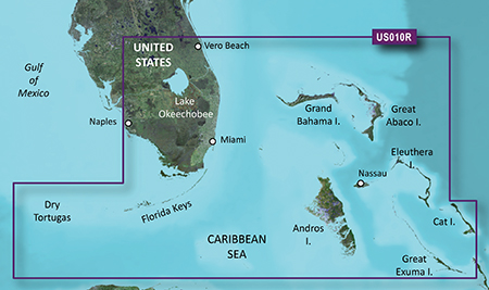
Bluechart G2 vision VUS010R Southeast Florida 2015.0 v.16.50
unl.img
- Hidden Content
- This board requires you to be registered and logged-in to view hidden content.
- Hidden Content
- This board requires you to be registered and logged-in to view hidden content.
Read more : Bluechart G2 vision VUS010R Southeast Florida 2015.0 v.16.50 | Views : 1910 | Replies : 0
Last 10 active topics
Statistics
Total posts 166131 • Total topics 17546 • Total members 689698


