It is currently Wed Nov 12, 2025 1:53 pm
 News of New Maps
Site map of New Maps » Forum : New Maps
.Typ Topo Pirineos (Spain) v.3.0..
Read more : .Typ Topo Pirineos (Spain) v.3.0.. | Views : 3696 | Replies : 0
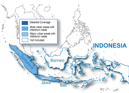
City Navigator Indonesia NT 2010.30 - Navteq
City Navigator Indonesia NT 2010.30 - Navteq
About Coverage
Includes coverage of Indonesia, including detailed coverage for the municipality of Jakarta.
Features
Download Locked Image
Download UnLocked Image
Pass: huntsman
MapID: 2151
More Info:
About Coverage
Includes coverage of Indonesia, including detailed coverage for the municipality of Jakarta.
Features
- Includes updated, fully-routable maps for Indonesia, including detailed coverage for the municipalities of Jakarta.
- Provides more than 249,000 km (155,000 mi) of road coverage.
- Contains more than 130,000 updated points of interest, including petrol stations, restaurants, hotels and shopping.
Download Locked Image
Download UnLocked Image
Pass: huntsman
MapID: 2151
More Info:
Read more : City Navigator Indonesia NT 2010.30 - Navteq | Views : 4481 | Replies : 1
Malsingmaps - MSM NT v5.07 (Brunei / Malaysia / Singapore Ma
Malsingmaps - MSM NT v5.07 (Brunei / Malaysia / Singapore Maps)
Released 15 Jan 2011
MSM Brunei / Malaysia / Singapore Maps
Download from one the following links:
Not locked
Download Image
or
Download Image
Released 15 Jan 2011
MSM Brunei / Malaysia / Singapore Maps
Download from one the following links:
Not locked
Download Image
or
Download Image
Read more : Malsingmaps - MSM NT v5.07 (Brunei / Malaysia / Singapore Ma | Views : 3912 | Replies : 0
City Navigator Singapore/Malaysia NT 2010.40 - Navteq
City Navigator Singapore/Malaysia NT 2010.40 - Navteq
MapID: 2368
Overview
We've made our map data even better and even easier for you to own! Our nüMaps Onetime City Navigator Singapore/Malaysia-Navteq 2010 map update¹ is available through download, to ensure you get the latest maps.
Download and Go
In today's fast-paced world, streets and points of interest are changing constantly. Don't get caught without the latest map data on your device. Conveniently download our nüMaps Onetime ...
Read more : City Navigator Singapore/Malaysia NT 2010.40 - Navteq | Views : 6326 | Replies : 5
HXRU001R BlueChart g2 Russian Inland Waterways V12.00
HXRU001R BlueChart g2 Russian Inland Waterways V12.00
See your surroundings more clearly with BlueChart® g2 data. With BlueChart g2, you’ll get detailed marine cartography that provides convenient viewing of nautical content. BlueChart g2 allows you to see your vessel’s precise, on-chart position in relation to navaids, coastal features, anchorages, obstructions, waterways, restricted areas and more. You also will have access to detailed mapping capabilities that include safety shading¹, fishing charts¹, smooth data transition between ...
See your surroundings more clearly with BlueChart® g2 data. With BlueChart g2, you’ll get detailed marine cartography that provides convenient viewing of nautical content. BlueChart g2 allows you to see your vessel’s precise, on-chart position in relation to navaids, coastal features, anchorages, obstructions, waterways, restricted areas and more. You also will have access to detailed mapping capabilities that include safety shading¹, fishing charts¹, smooth data transition between ...
Read more : HXRU001R BlueChart g2 Russian Inland Waterways V12.00 | Views : 4758 | Replies : 0
TOPO Poland 2011
TOPO Poland 2011
From the shores of the Baltic Sea to the summits of the Tatras, TOPO Poland 2011 is your active leisure companion when hiking, biking, cycling or even walking in the countryside. This product comes with detailed digital elevation models plus searchable POI's and 3-D elevation data for compatible Garmin units
From the shores of the Baltic Sea to the summits of the Tatras, TOPO Poland 2011 is your active leisure companion when hiking, biking, cycling or even walking in the countryside. This product comes with detailed digital elevation models plus searchable POI's and 3-D elevation data for compatible Garmin units
- Includes topographic maps of Poland in reference scale of 1:50.000.
- Displays dense contour intervals of 65.6 ft (20 m).
- Shows detailed digital ...
Read more : TOPO Poland 2011 | Views : 6124 | Replies : 7
Anavasi 4.55 Greek Road/TopoMap in IMG & MapSource
The new version of Greek map Anavasi (4.55) in IMG with two available color palettes for the user to choose & in MapSource.
Anavasi With TN Color Palette (IMG)


Anavasi With Garmin Color Palette (IMG)


Anavasi With TN Color Palette MapSource

Greek Anavasi 4.55 With TN Color Palette IMG
http://rapidshare.com/files/441165636/Greek_Anavasi_4.55_TN_Color_Palette.rar
Greek Anavasi 4.55 With Garmin Color Palette IMG
http://rapidshare.com/files/441165632/Greek_Anavasi_4.55_Garmin_Color_Palette.rar
Greek Anavasi 4.55 With Two Modified Color Palettes IMG ... New
Original_ _ ...
Read more : Anavasi 4.55 Greek Road/TopoMap in IMG & MapSource | Views : 4819 | Replies : 5
City Navigator Australia and New Zealand NT 2011.30
City Navigator Australia and New Zealand NT 2011.30
MapID: 2355
Travel Australia and New Zealand
City Navigator Australia & New Zealand NT provides highly detailed maps for your device and thousands of points
of interest (POIs) throughout the region, so you can navigate with exact, turn-by-turn directions to any address or intersection.
Coverage for Australia includes cities and national roads throughout the entire continent. Coverage for New Zealand includes
national roads throughout the country and ...
Read more : City Navigator Australia and New Zealand NT 2011.30 | Views : 4397 | Replies : 3
CNBR2011.40 + Autoguia 2.30 + TRC-BR 10.12
CNBR2011.40 + Autoguia 2.30 + TRC-BR 10.12
CNBr 2011.40
AutoGuia 2.30
TRC Brasil 10.12
Download UnLocked Image
or
Download UnLocked Image
Credit to rickymm
CNBr 2011.40
AutoGuia 2.30
TRC Brasil 10.12
Download UnLocked Image
or
Download UnLocked Image
Credit to rickymm
Read more : CNBR2011.40 + Autoguia 2.30 + TRC-BR 10.12 | Views : 5826 | Replies : 4
City Navigator Brazil NT 2011.40
City Navigator Brazil NT 2011.40
Released in: 16/12/2010
special features:
RodoAnel Mario Covas: included
Marginal Tiete: updated
Travel Brazil
Navigate the streets of Brazil with confidence. City Navigator Brazil NT provides detailed road maps and points of interest for your device, so you can navigate with exact, turn-by-turn directions to any address or intersection. Route to restaurants, gas stations, lodging, attractions and more. Coverage includes major road coverage throughout Brazil and detailed coverage for select ...
Read more : City Navigator Brazil NT 2011.40 | Views : 10189 | Replies : 9
Last 10 active topics
Statistics
Total posts 166194 • Total topics 17556 • Total members 690034