NepalTOPO NPL Routable - Countrywide Topographic Map of Nepal- 2010.10
This is the main topographical map of Nepal we publish. It's the map with the highest level of detail, capable for trekking in remote areas as well as navigating by car through the country. Besides topographical details this map includes a detailed street layer and all details of our street maps as well.
Because the map is fully routable, it also can be used for ...
It is currently Wed Nov 12, 2025 1:56 pm
 News of New Maps
Site map of New Maps » Forum : New Maps
NepalTOPO NPL Routable - Countrywide Topographic Map of Nepa
Read more : NepalTOPO NPL Routable - Countrywide Topographic Map of Nepa | Views : 8593 | Replies : 6
Tracks4Australia PRO
Tracks4Australia PRO
Tracks4Australia PRO is based on 1:250K road and map data licensed from Geoscience Australia. This data is being augmented with additional track log data from the Tracks4Australia mapping project contributors.
The aim of Tracks4Australia is to include all roads from freeways to 4WD tracks across rural Australia. It includes major roads in cities and major and secondary roads across the country.
Tracks4Australia PRO includes a find function for city and town names and ...
Read more : Tracks4Australia PRO | Views : 5546 | Replies : 4
Iran GPS map for Garmin 2.7.0
Iran GPS map for Garmin 2.7.0
released january 2011
Routable map
English
Tehran & Iran Navigation and Routable Map for Garmin, is the most detailed routable map of Iran available today for Garmin GPS devices. It includes:
released january 2011
Routable map
English
Tehran & Iran Navigation and Routable Map for Garmin, is the most detailed routable map of Iran available today for Garmin GPS devices. It includes:
- Complete detailed Maps of Ahvaz, Arak, Ardabil, Bam, Babol, Babolsar, Bandar-Abbas, Chalos, Dizin ski resort, Esfahan (Isfahan), Fereydoon kenar, Ghom (Qom), Hamedan, Kashan, Karaj, Kerman, Kish Island, Nour, Noshahr, Mashhad, Qeshm Island, Rasht, Sabzevar, Sari, Semnan, Shiraz, Tabriz, ...
Read more : Iran GPS map for Garmin 2.7.0 | Views : 7995 | Replies : 7
VAF002R BlueChart® g2 Vision South Africa v9.00
VAF002R BlueChart® g2 Vision South Africa v9.00
Detailed coverage of the coast of southern Africa from Namibe, Ang. to Angoche, Moz., including the South African cities of Cape Town and Port Elizabeth. Includes detailed coverage of Durban S. Af. and Maputo, Moz. Also includes detailed coverage of the Tristan da Cunha Group, the island of St. Helena, and the Prince Edward Islands.
PID 1, FID 235, region 2,2
Download Part 1 (350 MB)
Download Part ...
Read more : VAF002R BlueChart® g2 Vision South Africa v9.00 | Views : 3811 | Replies : 2
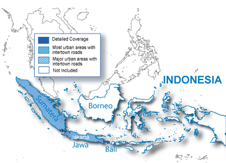
City Navigator Indonesia NT 2010.40
City Navigator Indonesia NT 2010.40
MapID: 2151
Download Locked Image
Download UnLocked Image
Pass: huntsman
MapID: 2151
Download Locked Image
Download UnLocked Image
Pass: huntsman
Read more : City Navigator Indonesia NT 2010.40 | Views : 7388 | Replies : 6
Nederland Binnenwateren - Dutch waterways
Hello i found this chart on the net and try to unlock it with 5.71 it say al is unlocked but homeport can't find it
maybe somebody can help
http://rapidshare.com/files/443633150/Nederland_binnenwateren_IMG.part1.rar
http://rapidshare.com/files/443633160/Nederland_binnenwateren_IMG.part2.rar
http://rapidshare.com/files/443633165/Nederland_binnenwateren_IMG.part3.rar
http://rapidshare.com/files/443633171/Nederland_binnenwateren_IMG.part4.rar
http://rapidshare.com/files/443633172/Nederland_binnenwateren_IMG.part5.rar
thanks and regards xlgsm
Read more : Nederland Binnenwateren - Dutch waterways | Views : 3197 | Replies : 1
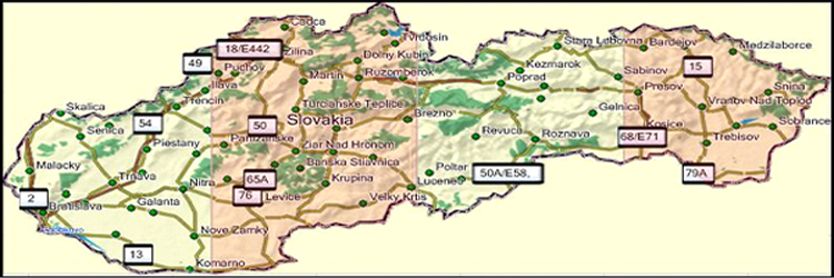
Garmin - Topo Slovakia v3
Topo Slovakia v3
Requirements: for all Garmin Devices
Overview: For tourism, sport and relaxation in the Slovak Republic. Map can be used for hiking and car navigation systems, Garmin, and within them to conveniently identify any TZT (signposted tourist route) or CT (cycle route). The most important GIS layer maps is digital, vector and topologically continuous mapping kit complete network of hiking trails and bicycle lanes .

Download Instructions:
Download Netload Topo Slovakia ...
Requirements: for all Garmin Devices
Overview: For tourism, sport and relaxation in the Slovak Republic. Map can be used for hiking and car navigation systems, Garmin, and within them to conveniently identify any TZT (signposted tourist route) or CT (cycle route). The most important GIS layer maps is digital, vector and topologically continuous mapping kit complete network of hiking trails and bicycle lanes .
Download Instructions:
Download Netload Topo Slovakia ...
Read more : Garmin - Topo Slovakia v3 | Views : 5347 | Replies : 1
City Navigator Israel NT 2011.40
City Navigator Israel NT 2011.40
released 03 Jan 2011
Visit Israel
Navigate the streets of Israel with confidence. City Navigator Israel NT provides detailed road maps and points of interest for your device, so you can navigate with exact, turn-by-turn directions to any address or intersection. Route to restaurants, gas stations, lodging, attractions and more. Coverage includes detailed maps for most of Israel, including major cities like Jerusalem, Tel-Aviv, Haifa and Eilat.
Features
- Displays ...
Read more : City Navigator Israel NT 2011.40 | Views : 6032 | Replies : 6
Topo Map Mexico 2011
Topographic map of Mexico
Read more : Topo Map Mexico 2011 | Views : 5232 | Replies : 8
Cityxplorer: 20 European, North and South American Cities
The following cities are included in the rar file.
Cityxplorer maps for:
Baltimore 2011.10
Berlin 2011.20
Budapest 2011.10
Cote d'Azur 2011.20
Florence (Firenze) 2011.20
Frankfurt 2011.30
Helsinki 2011.10
Krakow 2010.10
Madrid 2011.10
Moscow 2011.10
New York 2011.10
Oslo 2011.10
Paris 2011.10
Prague 2010.10 and 2011.30
Rio de Janeiro 2011.20 and 2011.30
Roma 2011.10
Sao Paulo 2011.10 and 2011.30
St. Petersburg 2011.10
Venice (Venezia) 2010.10
Wien 2011.20
Download link:
http://www.multiupload.com/00551ZP6RC
Read more : Cityxplorer: 20 European, North and South American Cities | Views : 4554 | Replies : 4
Last 10 active topics
Statistics
Total posts 166194 • Total topics 17556 • Total members 690034