 Forum
ForumGarmin - City Navigator Eastern Africa NT 2017.10
Requirements: garmin devices
Overview: avigate the streets of Eastern Africa with confidence. City Navigator Eastern Africa NT provides road maps and points of interest for your Garmin device, so you can navigate with exact, turn-by-turn directions to any address or intersection. Route to restaurants, gas stations, lodging, attractions and more in Kenya and Uganda. Powered by NAVTEQ, a world leader in premium-quality digital map data.
Coverage
Features ...

- Contact •
- FAQ •
- Register •
- Login
- View unanswered posts • View active topics
-
 Board index ‹ Site map ‹ News of NaviTotal.com ‹ News of New Maps
It is currently Wed Nov 05, 2025 6:15 am
 News of New Maps
Site map of New Maps » Forum : New Maps
Garmin - City Navigator Eastern Africa NT 2017.10
Read more : Garmin - City Navigator Eastern Africa NT 2017.10 | Views : 4446 | Replies : 3
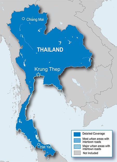
Garmin - City Navigator Thailand NT 2016.20 [Dual]
Garmin - City Navigator Thailand NT 2016.20
Requirements: Garmin Devices, PC
Overview: Features updated, fully-routable maps for Thailand, including detailed coverage for the municipalities of Chiang Mai, Krung Thep and Hat Yai.
•Updated detailed street maps.
•Updated points of interest, such as gas stations, parking garages, restaurants, hotels and ATM locations.
•Faster, more accurate routing when you drive with the latest map information.
More Info:
Download Instructions:
City Navigator Thailand NT 2016.20 ...
Requirements: Garmin Devices, PC
Overview: Features updated, fully-routable maps for Thailand, including detailed coverage for the municipalities of Chiang Mai, Krung Thep and Hat Yai.
•Updated detailed street maps.
•Updated points of interest, such as gas stations, parking garages, restaurants, hotels and ATM locations.
•Faster, more accurate routing when you drive with the latest map information.
More Info:
- Code: Select all
http://www.garmin.co.th/mapupdate/
Download Instructions:
City Navigator Thailand NT 2016.20 ...
Read more : Garmin - City Navigator Thailand NT 2016.20 [Dual] | Views : 13605 | Replies : 17
Garmin TOPO U.K. and Ireland v4 Light
Garmin TOPO U.K. and Ireland v4 Light
Requirements: compatible Garmin Devices
Overview:
This recreational map has been compiled using the community generated OpenStreetMap (OSM) database to which Garmin added a 50-metre contour line layer, based on a public digital elevation model, and over 20 years of knowledge and skills in building electronic maps.
The resulting map can be used for orienteering and reference for any outdoor or recreational activities throughout UK and Ireland. These new ...
Read more : Garmin TOPO U.K. and Ireland v4 Light | Views : 3997 | Replies : 1
Topo Chile Deluxe 2015.10
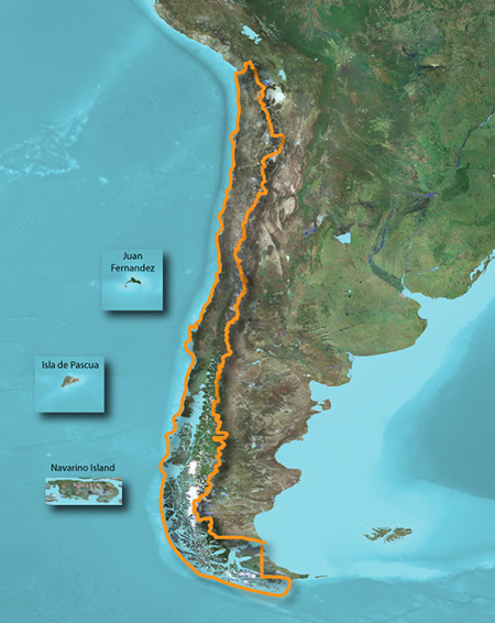
unl.img
- Hidden Content
- This board requires you to be registered and logged-in to view hidden content.
- Hidden Content
- This board requires you to be registered and logged-in to view hidden content.
Read more : Topo Chile Deluxe 2015.10 | Views : 4100 | Replies : 5
Garmin TOPO Belarus v3 Light
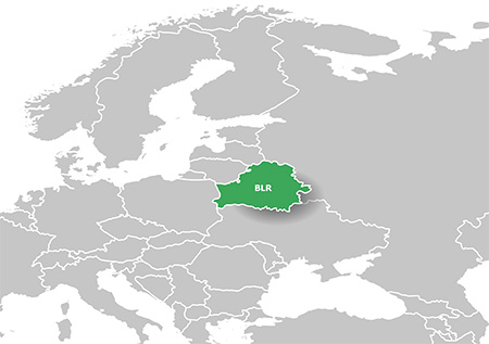
FID: 3973
unl.img
- Hidden Content
- This board requires you to be registered and logged-in to view hidden content.
Read more : Garmin TOPO Belarus v3 Light | Views : 3526 | Replies : 0
Garmin - Topo Portugal Light v3
Garmin - Topo Portugal Light v3
Requirements: Compatible with Garmin GPS, PC
Overview: Orienteer and reference any outdoor or recreational activity in Portugal with this map, compiled using the community-generated OpenStreetMap (OSM) database.
Includes more than 173,900 miles (280,000 km) of road, path and trail network with routing designed for recreational activities
Offers more than 69,000 points of interest database with popular tourist destinations, including restaurants, bars, hotels, car parks, campsites and more
Displays hydrographic ...
Read more : Garmin - Topo Portugal Light v3 | Views : 2765 | Replies : 1
City Navigator Russia NT 2017.10 - Navicom
City Navigator Russia NT 2017.10 - Navicom
FID: 4076
Map source data with .msi installer:
Image:
3D:
JCV:
FID: 4076
Map source data with .msi installer:


Image:


3D:


JCV:
Nuvi-40,50-Android: Download
- Code: Select all
Data JCV:  length 15959019, name D3528170A.jcv
   date 19.02.2016 10:04:09
   006-D3528-17
   picture size 212*234
LaneAssistPortraitFull: Download
- Code: Select all
Data JCV:  length 24587374, name D3527170A.jcv
   date 19.02.2016 11:43:29
   006-D3527-17
   picture size 212*234
Full-Screen: DownloadData JCV: length 37649270, name D3305190A.jcv
date ...


Read more : City Navigator Russia NT 2017.10 - Navicom | Views : 7389 | Replies : 4
City Navigator Europe NTU 2017.10
City Navigator Europe NTU 2017.10
FID: 4038
Map source data with .msi installer:
Image: ALL
3D:
JCV:
FID: 4038
Map source data with .msi installer:


Image: ALL


3D:


JCV:
JCV_LaneAssistPortraitFull: Download
- Code: Select all
Data JCV:  length 405703989, name D3048220A.jcv
   date 01.03.2016 18:54:52
   006-D3048-22
   picture size 212*234
JCV_Nuvi-40,50-Android: Download
- Code: Select all
Data JCV:  length 157894266, name D3589190A.jcv
   date 03.03.2016 11:45:01
   006-D3589-19
   picture size 212*234
JCV_Split-Screen: DownloadData JCV: length 196199620, name D3373200A.jcv
date 02.03.2016 ...


Read more : City Navigator Europe NTU 2017.10 | Views : 40782 | Replies : 15
TOPO Southern Africa v3 PRO
TOPO Southern Africa v3 PRO
We've mapped every hill and valley for your next great adventure in Southern Africa. These highly detailed topographic maps cover the finer destinations for recreational outdoor activities and serve as your ultimate guide to navigating trails, roads, rivers and forests.
We've mapped every hill and valley for your next great adventure in Southern Africa. These highly detailed topographic maps cover the finer destinations for recreational outdoor activities and serve as your ultimate guide to navigating trails, roads, rivers and forests.
- Includes ActiveRouting¹, allowing you to customize and specifically plan routes for the entire road and trail network. The activity-specific routing can be used in BaseCamp™ and on your compatible ...
Read more : TOPO Southern Africa v3 PRO | Views : 6679 | Replies : 10
TOPO Explorer Svalbard
TOPO Explorer Svalbard
Explore the Svalbard islands with these detailed topographic maps, including glaciers, moraines, coastlines and lakes. You'll also have coverage of national park borders, conservation areas and nature reserves.
Explore the Svalbard islands with these detailed topographic maps, including glaciers, moraines, coastlines and lakes. You'll also have coverage of national park borders, conservation areas and nature reserves.
- Provides 1:100,000 scale aerial photography and overview maps based on 1:1 million map data from the Norwegian Polar Institute
- Contains an extensive points of interest database with road and trail data
- Displays topographic features, including land use, glaciers, moraines and built ...
Read more : TOPO Explorer Svalbard | Views : 6536 | Replies : 16
Last 10 active topics
Statistics
Total posts 166125 • Total topics 17545 • Total members 689682


