
 Forum
Forum- Contact •
- FAQ •
- Register •
- Login
- View unanswered posts • View active topics
-
 Board index ‹ Site map ‹ News of NaviTotal.com ‹ News of New Maps
It is currently Wed Nov 05, 2025 6:15 am
 News of New Maps
Site map of New Maps » Forum : New Maps
City Navigator Europe NT 2017.10
Available do DL Garmin Express or garmin map updater 3.3.4
Read more : City Navigator Europe NT 2017.10 | Views : 3435 | Replies : 0
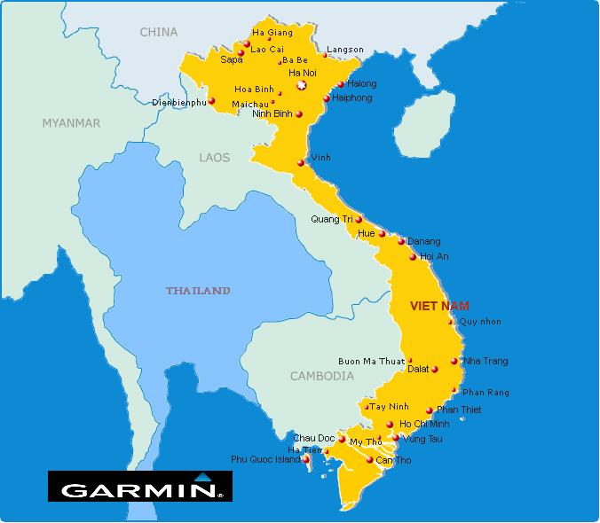
Garmin VietnamMap 2.08.0416
Garmin VietnamMap 2.08.0416
Requirements: garmin devices
Overview: routable Map of Vietnam
More Info:
Download Instructions:
inside:
unloked gmap folder
JCV file
POI files
Hoster
filefactory.com
share-online.biz
Requirements: garmin devices
Overview: routable Map of Vietnam
More Info:
- Code: Select all
http://www.garminvietnam.vn/Trang-Chu.aspx
Download Instructions:
- Hidden Content
- This board requires you to be registered and logged-in to view hidden content.
inside:
unloked gmap folder
JCV file
POI files
Hoster
filefactory.com
share-online.biz
Read more : Garmin VietnamMap 2.08.0416 | Views : 2048 | Replies : 0
Leaving to Australia tomorrow! RV 760LTM, need some help =/
Hey all!
So I have this installed on my mac's desktop: https://isohunt.to/torrent_details/13328531/Garmin-City-Navigator-Australia-And-New-Zealand-NT-2015-40-UNLOCKED
Its the 2015.40 for australia new zealand NT.
I own the RV 760LMT and we are leaving in a day. I am having trouble installing the above link to the device. I dont see the supp.img file anywhere, and tutorials are bland to my unit version.
Think anyone can help me out, I want to make this trip with my pops special, rented ...
Read more : Leaving to Australia tomorrow! RV 760LTM, need some help =/ | Views : 1609 | Replies : 0
Garmin TOPO Israel v3 Light
Garmin TOPO Israel v3 Light
Requirements: compatible Garmin Devices
Overview: Orienteer and reference any outdoor or recreational activity in Israel with this map, compiled using the community-generated OpenStreetMap (OSM) database.
Includes road, path and trail network with routing designed for recreational activities
Offers a large points of interest database with popular tourist destinations, including restaurants, bars, hotels, car parks, campsites and more
Displays hydrographic features, place names, man-made areas, natural features, land use areas, international ...
Read more : Garmin TOPO Israel v3 Light | Views : 4099 | Replies : 1
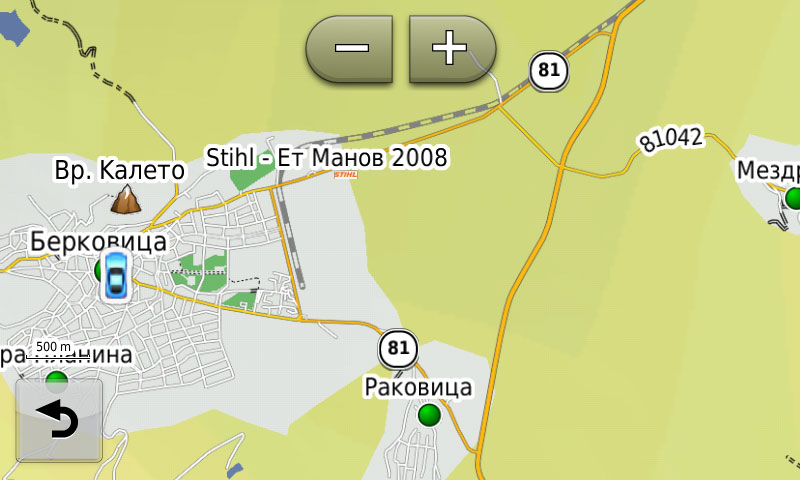
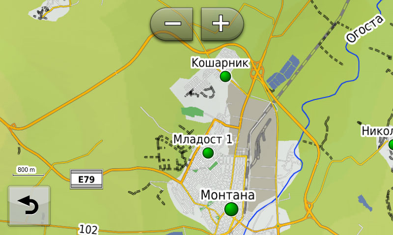
Bulgaria OFRM Geotrade 2016 Q1
The new version 2016 Q1 is now available.
Updates urban and national road network
In Q1 2016 version added new bypass roads near Berkovitsa and Montana, as well as the newly established North Tangent in Sofia.
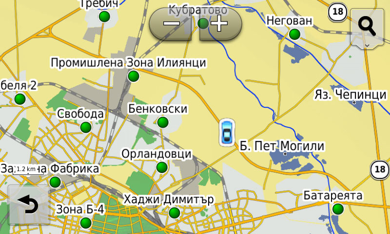
Extended coverage in settlements
Enriched information is available for searching by address (street and number) with new 10 settlements and to search by street name / junction with 3 new locations.
Added new objects of public interest (POI) ...
Updates urban and national road network
In Q1 2016 version added new bypass roads near Berkovitsa and Montana, as well as the newly established North Tangent in Sofia.
Extended coverage in settlements
Enriched information is available for searching by address (street and number) with new 10 settlements and to search by street name / junction with 3 new locations.
Added new objects of public interest (POI) ...
Read more : Bulgaria OFRM Geotrade 2016 Q1 | Views : 3024 | Replies : 0
Pleae help with turn by turn software
I realize this request may have been made many times, and for some may not be very bright to even have to ask for it, but I do need this help. I just got a new job that is very important for me and my family and I need to use a GPS without my new employer even finding out before I can get familiar with the area I am about to work in. I ...
Read more : Pleae help with turn by turn software | Views : 1666 | Replies : 1
(Request) Backroad Mapbooks Nova Scotia v5
Hi,
I am looking for a copy of Backroad Mapbooks Nova Scotia v5 or the whole Atlantic Canada version
Thank you
I am looking for a copy of Backroad Mapbooks Nova Scotia v5 or the whole Atlantic Canada version
Thank you
Read more : (Request) Backroad Mapbooks Nova Scotia v5 | Views : 1739 | Replies : 0
BlueChart g2 HXAE006R-Timor Leste-New Guinea v2015 16.50
BlueChart g2 HXAE006R-Timor Leste-New Guinea v2015.00 16.50
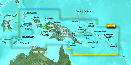
unl.img
unl.img
- Hidden Content
- This board requires you to be registered and logged-in to view hidden content.
- Hidden Content
- This board requires you to be registered and logged-in to view hidden content.
Read more : BlueChart g2 HXAE006R-Timor Leste-New Guinea v2015 16.50 | Views : 3067 | Replies : 2
Search "Canada Topo v4"
Hello everyone,
I am looking maps "Topo Canada v4" is it possible to find?
thank you for your feedback.
I am looking maps "Topo Canada v4" is it possible to find?
thank you for your feedback.
Read more : Search "Canada Topo v4" | Views : 2227 | Replies : 0
City Navigator Southern Africa NT 2017.10
City Navigator Southern Africa NT 2017.10
Navigate the streets with confidence. This product provides detailed road maps and points of interest for your device, so you can navigate with exact, turn-by-turn directions to any address or intersection.
Navigate the streets with confidence. This product provides detailed road maps and points of interest for your device, so you can navigate with exact, turn-by-turn directions to any address or intersection.
- Includes more than 2.2 million km (more than 1.3 million miles) of roads, including motorways, national and regional thoroughfares and local roads, in South Africa.
- Displays more than 400,000 points of interest throughout the country, including ...
Read more : City Navigator Southern Africa NT 2017.10 | Views : 5305 | Replies : 4
Last 10 active topics
Statistics
Total posts 166125 • Total topics 17545 • Total members 689682


