Forum
Forum
 News of New Maps
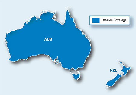
info
- Code: Select all
https://buy.garmin.com/shop/shop.do?pID=116482
•Includes nearly 1.3 million km (793,000 mi) of roads, including motorways, national and regional thoroughfares and local roads throughout Australia and New Zealand.
•Displays more than 572,000 points of interest throughout the countries, including restaurants, petrol stations, lodging, attractions, railways and more.
•Gives turn-by-turn directions on your compatible device.
•Speaks street names (example: "Turn right on Main Street")
•Includes navigational features, such as turn restrictions, roundabout guidance, speed categories and more.
•Contains ...