 Forum
ForumHi there,
I was passed down a Tom Tom One XL from my friend however the sd card that came with it was damaged. So i have a formatted fat32 sd card.
WHich version of the maps are compatiable with the Tom Tome One XL. My navcore is 8.010.
Thanks,

- Contact •
- FAQ •
- Register •
- Login
- View unanswered posts • View active topics
-
 Board index ‹ Site map ‹ News of NaviTotal.com
It is currently Fri Nov 28, 2025 8:19 pm
 News of NaviTotal.com
Site map of NaviTotal.com » Forum : NaviTotal.com
NaviTotal.com is a community where you can find all needed for your GPSUnsure which version of maps work with TomTom One XL
Read more : Unsure which version of maps work with TomTom One XL | Views : 1841 | Replies : 3 | Forum : General Discussions about TomTom
hgv poi uk
hi i have made these from tomtom poi but now working on igo primo 2 ie low bridge,width ,indust est ,7.5 weight limit hope some one can use them they work well for me
Read more : hgv poi uk | Views : 1350 | Replies : 0 | Forum : General Discussions about iGO core
New Map on carminat TOMTOM 8 842
Hello,
First thank you for the clear tuto "How to install a map in my Carminat Tomtom"
I follow step by step but when I try to update meta.txt, I have a message " Fastactivate have found potential drive: G - Enter your Tomtom device SD card drive letter :" and when I put "G", I ve got the same message in loop
DOes someone can help me to solve this issue ?
Thank you ...
Read more : New Map on carminat TOMTOM 8 842 | Views : 2634 | Replies : 0 | Forum : General Discussions about TomTom
Auto on/off fuction
Hi
I just received my 7" gps/reverse camera unit from china. It is running windows ce 6
Now my screen will turn on automatically when car is turn on. However it will not auto shut down when I turn off the car.
Is there a way to enable auto shutdown? Or is there a function in windows ce 6 where I can set it to go into sleep mode when car is turned off and ...
Read more : Auto on/off fuction | Views : 1894 | Replies : 3 | Forum : General Discussions about iGO core
Pocket Word and Pocket excel
Hello guys...
Does anyone has the pocket word,pocket excel and pocket powerpoint (included in windows ce 3 or older) ...i need them for my pna(it runs wndows ce 5 and im not sure if the pocket office would work) but i cannot take them from another device(with windows 3/2000) because it says "it's a part of the rom"....
If there are no files of pocket office can anyone suggest me a ms office application with ...
Read more : Pocket Word and Pocket excel | Views : 1696 | Replies : 0 | Forum : Other Systems
BlueChart g2 HEU506S Crete-Cyprus v2012.5 (v15.00)
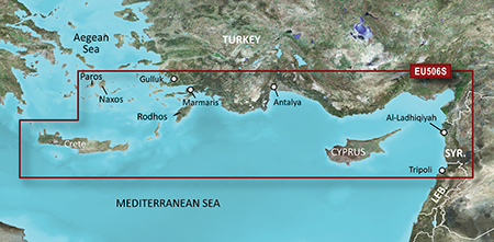
Read more : BlueChart g2 HEU506S Crete-Cyprus v2012.5 (v15.00) | Views : 2161 | Replies : 1 | Forum : New Maps
MapmyindiaV6 with sygic 8.3 for car gps device only
MapmyindiaV6 with sygic 8.3 for gps device only
Copy the below line to google search and you'll get many torrent sites for download:
MapmyindiaV6 with sygic 8.3 for gps device only
Once downloaded, follow the below steps:
Copy entire contents except keygen to SD card of the device. Keep the same on the computer too. You will need to use it for the key generation.
Open your GPS device and select the navi path to ...
Read more : MapmyindiaV6 with sygic 8.3 for car gps device only | Views : 2893 | Replies : 1 | Forum : Sygic System
please help i need a good working igo primo with resolution
hello,
who can help me with a good working igo primo for windows ce 6
it must bust be working on resolution 320x240
i have one but he ask for the ui-igo9\320-240\main-scheme.ui file.
so please help me with a complete working primo and not only a file.
and a link with one works, because the most links here are not working anymore or I came on suspicious sites..
thank and grtz chris
Read more : please help i need a good working igo primo with resolution | Views : 3933 | Replies : 14 | Forum : General Discussions about iGO core
Starting to hate free apps and so called downloads for hacks
I just started with a new phone and tablet, both runing on Android...
Since I started with computer stuff about 25 years ago I always valued free programs or offers for small and reasonable fee directly to the programmer - like you still see it for donation ware.
But using "freeware" on Android seems to be almost impossible unless you are willing to waste a lot of money on mobile data so get crap ads ...
Read more : Starting to hate free apps and so called downloads for hacks | Views : 1937 | Replies : 5 | Forum : Chit-Chat
iGOView 3.7.2.38 - By rpul
iGOView 3.7.2.38 - By rpul
OVERVIEW: a tool to view (limited) information from iGO content files (fbl, fda, ftr, fsp, poi ETC).
password: www.navitotal.com
OVERVIEW: a tool to view (limited) information from iGO content files (fbl, fda, ftr, fsp, poi ETC).
- Hidden Content
- This board requires you to be registered and logged-in to view hidden content.
password: www.navitotal.com
Read more : iGOView 3.7.2.38 - By rpul | Views : 6370 | Replies : 8 | Forum : Tools & Tutorials
Last 10 active topics
Statistics
Total posts 166353 • Total topics 17573 • Total members 690834


