 Forum
Forum; Argentina_Mapear_920_5240
20 B9 A4 66 4A 09 D2 12 67 9B 41 CB DC B3 8D 7D Argentina_Mapear-848.meta
; Australia_920_5276
1C 02 45 2C EB 01 B6 BF 9C E3 ED 56 C0 91 62 F8 Australia-863.meta
; Benelux_920_5276
91 5C BD 97 D8 A7 92 57 F2 A2 DA A5 03 E2 7F CF Benelux-863.meta
; Brazil_920_5276
80 BD C8 8A 3D 66 9D 33 2C 78 BF 02 33 6F C6 A0 ...

- Contact •
- FAQ •
- Register •
- Login
- View unanswered posts • View active topics
-
 Board index ‹ Site map ‹ News of NaviTotal.com
It is currently Fri Nov 28, 2025 9:05 pm
 News of NaviTotal.com
Site map of NaviTotal.com » Forum : NaviTotal.com
NaviTotal.com is a community where you can find all needed for your GPSAndroid v920 map meta codes
Read more : Android v920 map meta codes | Views : 3212 | Replies : 1 | Forum : Android Apps
Garmin Bluechart G2 Vision VUS035R Northern Coast Of Alaska
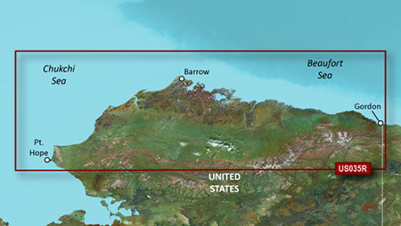
Read more : Garmin Bluechart G2 Vision VUS035R Northern Coast Of Alaska | Views : 2285 | Replies : 0 | Forum : New Maps
speedcams TomTom Go 6000
Hi everyone!
Someone knows how put speedcams in TomTom GO 6000?
Someone knows how put speedcams in TomTom GO 6000?
Read more : speedcams TomTom Go 6000 | Views : 3500 | Replies : 5 | Forum : General Discussions about TomTom
TTS works but talks over music then mutes.
Galaxy S3 T999, 4.1.2 rooted, iGO Primo 9.6.29.341779, US maps.
TTS is setup using either the installed Google or Samsung TTS engines, neither one changes the issue.
What I'm getting is it mutes all other sounds when it announces a maneuver for example "Take next right."
When it announces "Prepare to turn right after 1000 feet." for example what I get is it announces over any other sounds the "Prepare to turn right" and the ...
Read more : TTS works but talks over music then mutes. | Views : 2025 | Replies : 1 | Forum : Android Discussion
Garmin Europe Recreation Map
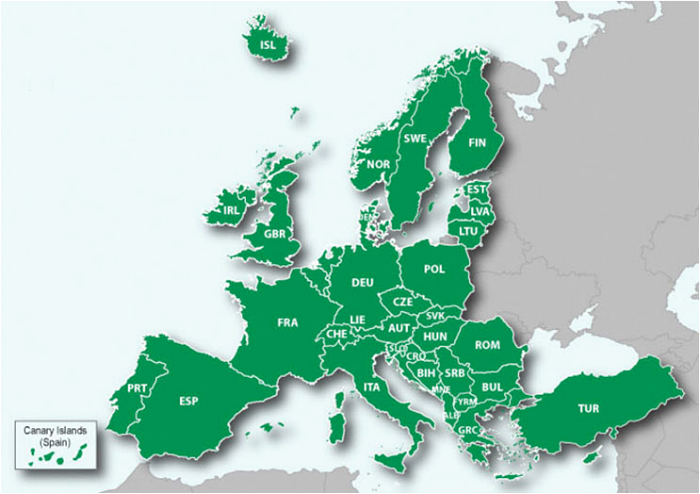
Details correspond to a 1:100.000 scale recreational paper map. Available for 48 countries across Western and Eastern Europe. Coverage detail varies depending on country. This map does not include any routing data and is unable to provide turn-by turn road navigation directions.
Recreation Map of Europe v.4
unl.img
- Hidden Content
- This board requires you to be registered and logged-in to view hidden content.
thanks to guy who share this map
Read more : Garmin Europe Recreation Map | Views : 6447 | Replies : 6 | Forum : New Maps
iGO Primo all Voices + New Voices-december 2013.
kokolo its back with voices.
thanks walter66 for this.
--------------------------------------------------------------------------------------------
iGO Primo all Voices:
ABC (Ara, Bul, Cat, Cmn, Cro, Cze)
DE (Dan, Deu, Dut, Eng(aus,uk,us), Est)
FGHI (Fin, Fle, Fra, Gre, Hb, Hun, Ita)
LMNPR (Lit, Lva, Mol, Nor, Pol, Por, Rom, Rus)
STUY (Slo, Srb, Svn, Swe, Tur, Ukr, Yue)
New Voices:
ABC (Ara, Bul, Cat, Cmn, Cro, Cze)
DE (Dan, Deu, Dut, Eng(aus,uk,us), Est)
FGHI (Fin, Fle, Fra, Gre, Hb, Hun, Ita) ...
Read more : iGO Primo all Voices + New Voices-december 2013. | Views : 8841 | Replies : 8 | Forum : Android Apps
Help please Garmin 250w not starting
Hi
I have a nuvi 250w
Garmin not starting.
Garmin start to (2007 sirfstar) and start again and that turn by.
What can I do?
Have your software.
I am going to try with sd card.
I have a nuvi 250w
Garmin not starting.
Garmin start to (2007 sirfstar) and start again and that turn by.
What can I do?
Have your software.
I am going to try with sd card.
Read more : Help please Garmin 250w not starting | Views : 1712 | Replies : 0 | Forum : General Discussions about Garmin
HI:001:
I'm looking skin iGO Primo 9.6.22.317625. for an Android tablet: Lenovo IdeaTab A1000-f and sys.tex parameter.
thank you
Résolution : 1024x600 / 600x1024
or any IGO for this tablet
I'm looking skin iGO Primo 9.6.22.317625. for an Android tablet: Lenovo IdeaTab A1000-f and sys.tex parameter.
thank you
Résolution : 1024x600 / 600x1024
or any IGO for this tablet
Read more : | Views : 2228 | Replies : 5 | Forum : Android Discussion
Gjak 1.09 800x480 and iGo 2.4: removing battery status on navigatemap
Hi,
a couple of days ago I decided to go back to gjak skin.
It's awesome having the altimeter infos and the tracked satellites below, but the battery icon is very annoying especially when somone's using a car stereo.
So I modified the code, replacing that info with the current time so as to view the compass and direction on the up right corner. (So compass instead of current time)
The file posted has to ...
Read more : Gjak 1.09 800x480 and iGo 2.4: removing battery status on navigatemap | Views : 2566 | Replies : 0 | Forum : General Discussions about iGO core
Philippine Map
I found a Philippine map using this site http://www.motevo.ph/updates.html
Read more : Philippine Map | Views : 4089 | Replies : 2 | Forum : PaPaGO! Maps
Last 10 active topics
Statistics
Total posts 166353 • Total topics 17573 • Total members 690837


