 Forum
ForumHello,
What is the best navcore for my TOMTOM ONE V4?
Thank you

- Contact •
- FAQ •
- Register •
- Login
- View unanswered posts • View active topics
-
 Board index ‹ Site map ‹ News of NaviTotal.com
It is currently Sat Nov 29, 2025 4:50 pm
 News of NaviTotal.com
Site map of NaviTotal.com » Forum : NaviTotal.com
NaviTotal.com is a community where you can find all needed for your GPSnavcore TOMTOM ONE V4
Read more : navcore TOMTOM ONE V4 | Views : 6035 | Replies : 1 | Forum : > Navcores 9 for TomTom Devices
nuvi 30. How do I update the map?
Where do I start? I'm a complete newbie for Garmins. I have been updating Tom Tom's for many years. Have just been asked to update my step-daughters nuvi 30. Tried looking at the tutorials but a lot of the links no longer exist. Sorry for being a pain, but just don't know where to start. Thanks in advance for any help.
Read more : nuvi 30. How do I update the map? | Views : 3145 | Replies : 2 | Forum : General Discussions about Garmin
TomTom: Radar Europe voice Romanian / English
Radar Europe

Installation and activation of attractions with audio alerts:
1. Copy all files from folders POI Base files and POI default files to folder maps
tomtom\com.tomtom.europe\files\Europe
2. Start or install TomTom and set
Menu/Settings/TomTom Services/Data Services - turn off option
then
Menu/Settings/Advanced Settings/Auto hide route summary after 10 seconds - turn on option
3. Close TomTom
4. Copy all files from folder POI Final (VER) files to folder maps
tomtom\com.tomtom.europe\files\Europe
5. Run TomTom ...
Read more : TomTom: Radar Europe voice Romanian / English | Views : 3914 | Replies : 4 | Forum : Android Discussion
TomTom Home Update
Hello guys!
I was wondering if we do the "TomTom application for Car and Motor Navigation" (33.5 MB) update in tomtom home, can we still use the maps from this site, or does this update block it?
When we try to update gps fix, they obligate you to update this application.
I am afraid if I update this, the maps will stop working!
Thanks a lot! :023:
Read more : TomTom Home Update | Views : 2131 | Replies : 2 | Forum : General Discussions about TomTom
Need Help
Excuse my english , but I will try to expain my problem
I have Magellan 1700 with Igo Primi on it directly (No SD card) the problem I have at this time is I don't have access at my USB port .. I think the person make this renamed the xxxx. EXE to IBOOT directly and now it bypass my boot loading from Magellan... Someone know if it possible to BYPASS "IGO" on boot and ...
I have Magellan 1700 with Igo Primi on it directly (No SD card) the problem I have at this time is I don't have access at my USB port .. I think the person make this renamed the xxxx. EXE to IBOOT directly and now it bypass my boot loading from Magellan... Someone know if it possible to BYPASS "IGO" on boot and ...
Read more : Need Help | Views : 1448 | Replies : 5 | Forum : General Discussions about iGO core
Iphone TomTom Europe v 1.29 v1035.9676
Iphone TomTom Europe v 1.29 v1035.9676
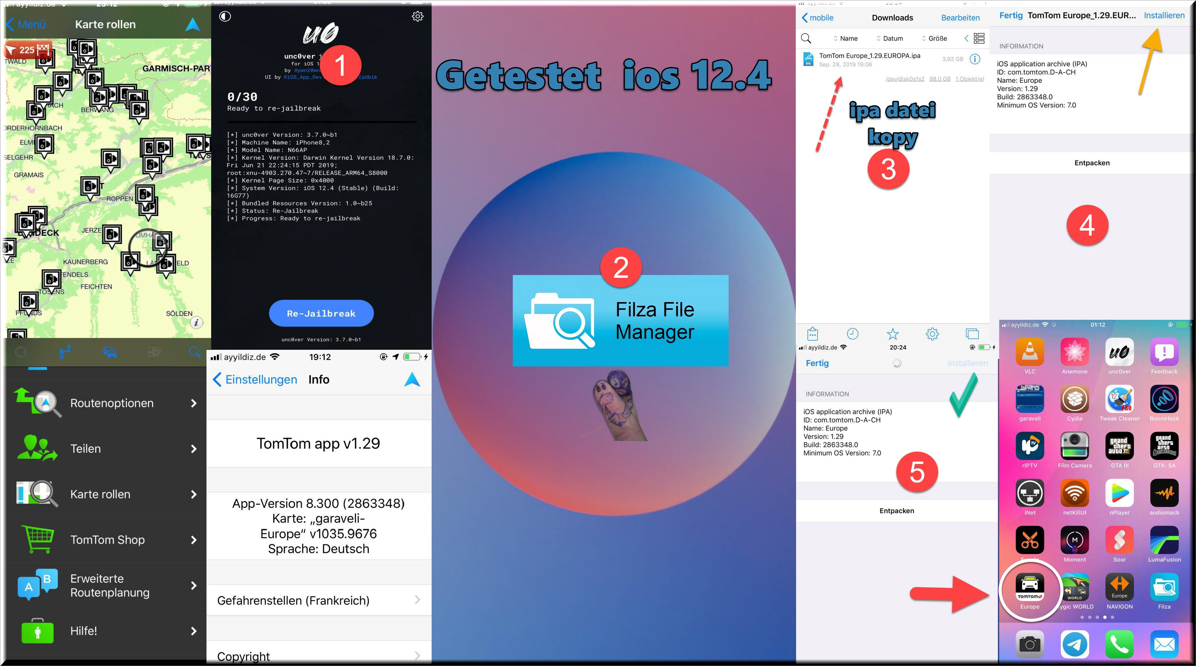
Password
- Code: Select all
Uploaded links
1 Gb Links
https://filecrypt.cc/Container/CE3FBE13F4.html

Single Link

https://filecrypt.cc/Container/163EB61E94.html

----------------------------------------------------------------------------------------------------------------------------------

Filefactory Links
Single Link

https://www.filefactory.com/file/6cxf10mz2pfp/SL.TT.EUR.1.29.v1035.9676.rar

1 Gb Links

https://www.filefactory.com/file/7smpyravbl/TT.EUR.1.29.v1035.9676.part1.rar
https://www.filefactory.com/file/3uq7w64n48zn/TT.EUR.1.29.v1035.9676.part2.rar
https://www.filefactory.com/file/4hmuoo2ba3tf/TT.EUR.1.29.v1035.9676.part3.rar
https://www.filefactory.com/file/1vtxv7ggq79p/TT.EUR.1.29.v1035.9676.part4.rar
Password
- Code: Select all
FROST
Read more : Iphone TomTom Europe v 1.29 v1035.9676 | Views : 13041 | Replies : 9 | Forum : iPhone Apps
IGO 8 on Eonon GM5153
Hi guys, I am complete newbie and desperately need some help with installing IGO8 on my recently purchased Eonon GM5153 with the following GPS specifications:
Operation System: Microsoft Windows CE.NET 6.0
CPU: SIRF atlas V——500 MHZ
SDRAM: 128MB
NAND FLASH: 128M
Map Storage Mode: Micro SD CARD (with a KUDOS 4G Micro Card)
GPS Model: SIRF V
Max Channels: 64
Sensitivity: -161Dbm
Cold Start: 38S
Warm Start: < 32 S
Hot Start: < 1 S ...
Operation System: Microsoft Windows CE.NET 6.0
CPU: SIRF atlas V——500 MHZ
SDRAM: 128MB
NAND FLASH: 128M
Map Storage Mode: Micro SD CARD (with a KUDOS 4G Micro Card)
GPS Model: SIRF V
Max Channels: 64
Sensitivity: -161Dbm
Cold Start: 38S
Warm Start: < 32 S
Hot Start: < 1 S ...
Read more : IGO 8 on Eonon GM5153 | Views : 10296 | Replies : 19 | Forum : General Discussions about iGO core
BlueChart g2 Vision - VEU019R - Alborg-Amsterdam 2014.0 (15.50)
BlueChart g2 Vision - VEU019R - Alborg-Amsterdam 2014.0 (15.50)
See your vessel’s precise, on-chart position in relation to navaids, coastal features and restricted areas with premium features found in this detailed marine mapping data. Includes all of the features of our BlueChart® g2 product, plus 3-D perspective above and below the waterline, Auto Guidance, high-resolution imagery, and aerial photos of ports, harbors, marinas and landmarks.
See your vessel’s precise, on-chart position in relation to navaids, coastal features and restricted areas with premium features found in this detailed marine mapping data. Includes all of the features of our BlueChart® g2 product, plus 3-D perspective above and below the waterline, Auto Guidance, high-resolution imagery, and aerial photos of ports, harbors, marinas and landmarks.
- Shaded depth contours, coastlines, spot soundings, navaids, port plans, ...
Read more : BlueChart g2 Vision - VEU019R - Alborg-Amsterdam 2014.0 (15.50) | Views : 1730 | Replies : 1 | Forum : New Maps
BlueChart g2 Vision - VEU004R - Irish Sea 2014.0 (15.50)
BlueChart g2 Vision - VEU004R - Irish Sea 2014.0 (15.50)
See your vessel’s precise, on-chart position in relation to navaids, coastal features and restricted areas with premium features found in this detailed marine mapping data. Includes all of the features of our BlueChart® g2 product, plus 3-D perspective above and below the waterline, Auto Guidance, high-resolution imagery, and aerial photos of ports, harbors, marinas and landmarks.
See your vessel’s precise, on-chart position in relation to navaids, coastal features and restricted areas with premium features found in this detailed marine mapping data. Includes all of the features of our BlueChart® g2 product, plus 3-D perspective above and below the waterline, Auto Guidance, high-resolution imagery, and aerial photos of ports, harbors, marinas and landmarks.
- Shaded depth contours, coastlines, spot soundings, navaids, port ...
Read more : BlueChart g2 Vision - VEU004R - Irish Sea 2014.0 (15.50) | Views : 3446 | Replies : 4 | Forum : New Maps
BlueChart g2 - HEU008R - Bay of Biscay 2014.0 (15.50)
BlueChart g2 - HEU008R - Bay of Biscay 2014.0 (15.50)
See your vessel’s precise, on-chart position in relation to navaids, coastal features, anchorages, obstructions, waterways, restricted areas and more with this detailed marine mapping data.
See your vessel’s precise, on-chart position in relation to navaids, coastal features, anchorages, obstructions, waterways, restricted areas and more with this detailed marine mapping data.
- Shaded depth contours, coastlines, spot soundings, navaids, port plans, wrecks, obstructions, intertidal zones, restricted areas and IALA symbols.
- Seamless transitions between zoom levels and more continuity across chart boundaries.
- Standard 2-D direct overhead or 3-D “over the ...
Read more : BlueChart g2 - HEU008R - Bay of Biscay 2014.0 (15.50) | Views : 4095 | Replies : 6 | Forum : New Maps
Last 10 active topics
Statistics
Total posts 166363 • Total topics 17574 • Total members 690876


