TOPO Southern Africa v3 PRO   

TOPO Southern Africa v3 PRO

Postby huntsman » Wed Apr 06, 2016 3:05 pm

TOPO Southern Africa v3 PRO

We've mapped every hill and valley for your next great adventure in Southern Africa. These highly detailed topographic maps cover the finer destinations for recreational outdoor activities and serve as your ultimate guide to navigating trails, roads, rivers and forests.

  • Includes ActiveRouting¹, allowing you to customize and specifically plan routes for the entire road and trail network. The activity-specific routing can be used in BaseCamp™ and on your compatible device.
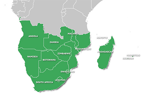
  • Shows seamless coverage between 14 different countries in Southern Africa. For the countries of Namibia and South Africa, it includes farm boundary information, which can help identify property borders
  • Displays searchable business/touristic points of interests, including searchable geographic places and mountain ranges
  • Includes an improved basemap with faster panning so you can see height contour lines and Digital Elevation Model (DEM) to easily estimate terrain difficulty
Features topographic coverage for Angola, Botswana, Lesotho, Madagascar, Malawi, Mauritius, Mayotte, Mozambique, Namibia, Reunion, South Africa, Swaziland, Zambia and Zimbabwe.

FID: ZA 3976
FID: Madagascar 4090


Image: Southern Africa v3 PRO & Madagascar
Locked: [Please Register or Login to download file]
Image

UnLocked: [Please Register or Login to download file]
Image


Image
Code: Select all
https://buy.garmin.com/en-US/US/prod536642.html
huntsman offline


User avatar Elite Member


Joined: Fri Sep 17, 2010 8:58 pm
Posts: 970
Has thanked: 2 times
Been thanked: 1295 times

Re: TOPO Southern Africa v3 PRO

Postby bam-bam » Thu Apr 14, 2016 2:50 pm

TOPO_Southern_Africa_v3_PRO_Madagascar
This board requires you to be registered and logged-in to view hidden content.

TOPO_Southern_Africa_v3_PRO
This board requires you to be registered and logged-in to view hidden content.


mirrors
This board requires you to be registered and logged-in to view hidden content.

This board requires you to be registered and logged-in to view hidden content.
bam-bam offline


User avatar Ex Moderator


Joined: Fri Jul 23, 2010 9:43 pm
Posts: 1420
Location: .BG
Has thanked: 51 times
Been thanked: 2004 times
Age: 44

Re: TOPO Southern Africa v3 PRO

Postby fjjohannn » Mon May 30, 2016 7:05 am

Once I have downloaded the files how does one build the file or load it into Basecamp so that it can loaded onto the card in the GPS...
fjjohannn offline


Junior Member


Joined: Tue Feb 02, 2016 12:07 pm
Posts: 3
Has thanked: 1 time
Been thanked: 0 time

Re: TOPO Southern Africa v3 PRO

Postby Dmitry2011 » Fri Jun 02, 2017 7:44 pm

Hello,

Please update link for on 1fichier.com

Thanks
Dmitry2011 offline


Junior Member


Joined: Fri Mar 24, 2017 2:14 am
Posts: 4
Has thanked: 3 times
Been thanked: 0 time

Re: TOPO Southern Africa v3 PRO

Postby Jnr » Thu Dec 27, 2018 5:09 pm

Hi,

Oregon 700 reports "Cannot authenticate maps". Please assist on the procedure to get the maps working?

Thanks
Jnr offline


Junior Member


Joined: Sat Dec 15, 2012 12:26 pm
Posts: 4
Has thanked: 2 times
Been thanked: 0 time

Re: TOPO Southern Africa v3 PRO

Postby bommelb » Sat Dec 29, 2018 12:37 pm

I asume that map is unlocked.
2e step is changing the CodePage (CP) in the map from 65001 tot 1252 with tools like IMGTool.
It's not nessary to patch your firmware.
More information: viewtopic.php?f=89&t=17987
bommelb offline


Junior Member


Joined: Mon May 24, 2010 3:03 pm
Posts: 88
Has thanked: 92 times
Been thanked: 64 times

Re: TOPO Southern Africa v3 PRO

Postby Remcard » Tue Dec 01, 2020 10:35 am

Is it possible please can you update the download links, be most grateful, Many Thanks
Remcard offline


Junior Member


Joined: Mon Nov 30, 2020 10:01 am
Posts: 1
Has thanked: 0 time
Been thanked: 0 time

Re: TOPO Southern Africa v3 PRO

Postby aa77260 » Sun Oct 31, 2021 4:31 pm

Hi all dowload links seems to be dead :022:
aa77260 offline


Junior Member


Joined: Tue Oct 24, 2017 8:28 am
Posts: 2
Has thanked: 0 time
Been thanked: 0 time

Re: TOPO Southern Africa v3 PRO

Postby napster1988 » Wed Apr 20, 2022 9:33 pm

Hello all,
Anyone can help with Southern Africa Map? Can you please upload again Southern Africa v3?
napster1988 offline


Junior Member


Joined: Mon Apr 18, 2022 2:56 pm
Posts: 1
Has thanked: 0 time
Been thanked: 0 time

Re: TOPO Southern Africa v3 PRO

Postby FireFox58 » Fri May 20, 2022 4:09 pm

TOPO Southern Africa v3 PRO - Original Locked IMG
GMapTool Info:
Spoiler: Show
Code: Select all
File:        /Mappe Africa/TOPO Southern Africa v3 PRO/gmapsupp.img, lunghezza 2628976640
Header:       03.11.2015 23:21:26, DSKIMG, XOR 00, V 3.00, Ms 0, 006-D4382-01
Mappa:        TOPO Southern Africa v3 PRO
fat:        1000h - 1200h - 40000h, blocco 65536
mappe:        198, sub-files 393

Sub-file         fat     lungh.
 00003976 MD2   1200h    309960
    data 03.11.2015 23:07:50
    000-00000-00
 00003976 MDR   1400h   7261571
    data 03.11.2015 23:07:47, CP 65001
 00003976 SRT   1600h    154286
 I0000F88 TYP   1800h     57020
    data 03.11.2015 15:49:43
    CP 65001, PID 1, FID 3976
 I10228C3 GMP   1A00h   5992380
    GMP: TRE RGN LBL NET NOD DEM
    GMP: data 03.11.2015 21:23:34
    mappa 10228c3 (16918723)
    PID 1, FID 3976, regione 0,0
    TRE: data 03.11.2015 21:23:34
    draw priority 30, parametri 1 4 10 13, [COLOR=#ff0000][B]bloccata[/B][/COLOR], [COLOR=#ff0000][B]firmato[/B][/COLOR]
    N: -9.999962, S: -12.000031, W: 21.999993, E: 24.000020
    TOPO Southern Africa v3 PRO
    Copyright 1995-2015 by GARMIN Corporation.
    CP 65001, UTF8
    DEM layers: 4, N: -9.999926, W: 21.999559
 I10228C3 SRT   1C00h    154286
 I10228C4 GMP   1E00h  24851794
    GMP: TRE RGN LBL NET NOD DEM
    GMP: data 03.11.2015 21:23:23
    mappa 10228c4 (16918724)
    PID 1, FID 3976, regione 0,0
    TRE: data 03.11.2015 21:23:23
    draw priority 30, parametri 1 4 10 13, [COLOR=#ff0000][B]bloccata[/B][/COLOR], [COLOR=#ff0000][B]firmato[/B][/COLOR]
    N: -9.999962, S: -12.000031, W: 31.999998, E: 34.000025
    TOPO Southern Africa v3 PRO
    Copyright 1995-2015 by GARMIN Corporation.
    CP 65001, UTF8
    DEM layers: 4, N: -9.999926, W: 31.999947
 I10228C4 SRT   2200h    154286
 I10228C5 GMP   2400h   7268726
    GMP: TRE RGN LBL NET NOD DEM
    GMP: data 03.11.2015 21:24:23
    mappa 10228c5 (16918725)
    PID 1, FID 3976, regione 0,0
    TRE: data 03.11.2015 21:24:23
    draw priority 30, parametri 1 4 10 13, [COLOR=#ff0000][B]bloccata[/B][/COLOR], [COLOR=#ff0000][B]firmato[/B][/COLOR]
    N: -7.999978, S: -10.000005, W: 12.915716, E: 14.000015
    TOPO Southern Africa v3 PRO
    Copyright 1995-2015 by GARMIN Corporation.
    CP 65001, UTF8
    DEM layers: 4, N: -7.999755, W: 12.915279
    ...

TOPO Southern Africa v3 PRO.rar (2.16 GB): [Please Register or Login to download file]

TOPO Southern Africa v3 PRO - Madagascar (UnLocked IMG)
GMapTool Info:
Spoiler: Show
Code: Select all
File:        /Mappe Africa/Madagascar/TOPO Southern Africa v3 PRO - Madagascar/gmapsupp.img, lunghezza 100802560
Header:       03.11.2015 15:33:27, DSKIMG, XOR 00, V 3.00, Ms 0, 006-D6123-00
Mappa:        TOPO Southern Africa v3 PRO - Madagascar
fat:        1000h - 1200h - A000h, blocco 8192
mappe:        8, sub-files 14

Sub-file         fat     lungh.
 00004090 MDR   1200h   4230641
    data 03.11.2015 15:31:00, CP 65001
 00004090 SRT   1800h    154286
 I0000FFA TYP   1A00h    109574
    data 03.11.2015 15:28:33
    CP 65001, PID 1, FID 4090
 I1022722 GMP   1C00h  21278342
    GMP: TRE RGN LBL NET NOD DEM
    GMP: data 03.11.2015 14:20:57
    mappa 1022722 (16918306)
    TRE: data 03.11.2015 14:20:57
    draw priority 29, parametri 1 4 9 13
    livelli [15,16,17,18,20,22,24], zoom [86,85,84,3,2,1,0]
    N: -18.777266, S: -25.352111, W: 46.835661, E: 49.402814
    OSM Madagaskar
    Copyright 1995-2015 by GARMIN Corporation.
    CP 65001, UTF8
    DEM layers: 1, N: -18.776893, W: 46.835630
 I1022722 SRT   3200h    154286
 I1022723 GMP   3400h  32907843
    GMP: TRE RGN LBL NET NOD DEM
    GMP: data 03.11.2015 14:21:06
    mappa 1022723 (16918307)
    TRE: data 03.11.2015 14:21:06
    draw priority 29, parametri 1 4 9 13
    livelli [15,16,17,18,20,22,24], zoom [86,85,84,3,2,1,0]
    N: -11.749063, S: -18.777308, W: 46.835661, E: 50.698385
    OSM Madagaskar
    Copyright 1995-2015 by GARMIN Corporation.
    CP 65001, UTF8
    DEM layers: 1, N: -11.748675, W: 46.835630
 I1022723 SRT   5600h    154286
 I1022724 GMP   5800h  16537677
    GMP: TRE RGN LBL NET NOD DEM
    GMP: data 03.11.2015 14:22:43
    mappa 1022724 (16918308)
    TRE: data 03.11.2015 14:22:43
    draw priority 29, parametri 1 4 9 13
    livelli [15,16,17,18,20,22,24], zoom [86,85,84,3,2,1,0]
    N: -22.291346, S: -25.805469, W: 43.009415, E: 46.835704
    OSM Madagaskar
    Copyright 1995-2015 by GARMIN Corporation.
    CP 65001, UTF8
    DEM layers: 1, N: -22.290585, W: 43.008795
    ...


TOPO Southern Africa v3 PRO - Madagascar.rar (84.1 MB): [Please Register or Login to download file]

Password for All Archives: FireFox58
FireFox58 offline


User avatar Member


Joined: Sun Sep 25, 2011 9:10 am
Posts: 219
Location: Florence, Italy
Has thanked: 32 times
Been thanked: 531 times


Return to New Maps


  • Related topics
    Replies
    Views
    Last post

Who is online

Users browsing this forum: Bing [Bot] and 8 guests