TOPO Poland 2011   

TOPO Poland 2011

Postby huntsman » Sat Jan 08, 2011 8:09 am

[SIZE="4"]TOPO Poland 2011[/size]

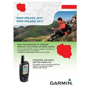
From the shores of the Baltic Sea to the summits of the Tatras, TOPO Poland 2011 is your active leisure companion when hiking, biking, cycling or even walking in the countryside. This product comes with detailed digital elevation models plus searchable POI's and 3-D elevation data for compatible Garmin units
  • Includes topographic maps of Poland in reference scale of 1:50.000.
  • Displays dense contour intervals of 65.6 ft (20 m).
  • Shows detailed digital elevation models and 3-D shading on compatible units.
  • Features routable roads on the entire street and trail network.
  • Displays land use, such as forests, lakes, streams and mountains.
  • Includes searchable points of interest for recreational activities, business and traveling.
  • Features 2-D footprint of buildings in more than 40 cities.
MapID: 2306

[SIZE="3"][Please Register or Login to download file] [/size]
or
[SIZE="3"][Please Register or Login to download file] [/size]

[SIZE="3"][Please Register or Login to download file] [/size]

[SIZE="3"][Please Register or Login to download file] [/size]


[Please Register or Login to download file]
Image
Thanks to Catymag
huntsman offline


User avatar Elite Member


Joined: Fri Sep 17, 2010 8:58 pm
Posts: 970
Has thanked: 2 times
Been thanked: 1295 times

Postby najkrid » Sun Jan 09, 2011 7:15 pm

Thanks for IMG file. Is MapSource version available?
najkrid offline


Junior Member


Joined: Sun Jan 09, 2011 7:11 pm
Posts: 2
Has thanked: 0 time
Been thanked: 0 time

Postby Traveller66 » Sun Jan 09, 2011 9:02 pm

It's easy to do it with gmaptool by yourself.[Please Register or Login to download file]
Traveller66 offline


Junior Member


Joined: Wed Dec 30, 2009 2:55 am
Posts: 17
Location: Germany
Has thanked: 8 times
Been thanked: 41 times

Postby najkrid » Sun Jan 09, 2011 9:06 pm

True, but doesn't that reduce search capabilities? Thanks for the tip though.
najkrid offline


Junior Member


Joined: Sun Jan 09, 2011 7:11 pm
Posts: 2
Has thanked: 0 time
Been thanked: 0 time

Postby Traveller66 » Sun Jan 09, 2011 9:46 pm

I think most of Mapsource Versions here are created at this way. Im not using it for CN but for a Topo seems to be ok.
Traveller66 offline


Junior Member


Joined: Wed Dec 30, 2009 2:55 am
Posts: 17
Location: Germany
Has thanked: 8 times
Been thanked: 41 times

Postby huntsman » Tue Jan 25, 2011 4:53 pm

Mapsource Added...
huntsman offline


User avatar Elite Member


Joined: Fri Sep 17, 2010 8:58 pm
Posts: 970
Has thanked: 2 times
Been thanked: 1295 times

Postby ozboss » Tue Jan 25, 2011 6:52 pm

and here unlocked mapsource gmap folder

Download Instructions:
[Please Register or Login to download file] Image
MapID: 2306
password: ozboss18
ozboss offline


User avatar Ex Moderator


Joined: Mon Dec 28, 2009 3:42 pm
Posts: 336
Has thanked: 0 time
Been thanked: 372 times

FileServe mirrors

Postby Waterr » Tue Jan 25, 2011 8:43 pm

[color="orange"][SIZE="5"]
FileServe:
[/size][/color]


[SIZE="4"][Please Register or Login to download file]

[Please Register or Login to download file]

[Please Register or Login to download file] [/size]


[SIZE="3"]MapID: 2306[/size]
Waterr offline


Junior Member


Joined: Sat Nov 20, 2010 4:17 pm
Posts: 2
Has thanked: 0 time
Been thanked: 0 time


Return to New Maps


  • Related topics
    Replies
    Views
    Last post

Who is online

Users browsing this forum: No registered users and 11 guests