TOPO Alpina Espana
Wed Jul 04, 2012 11:00 pm
TOPO Alpina Espana - Sistema Central - Picos v2.00
info
Version: 2.00
Released: Jan, 2011
Part Number: 010-D0982-00 (Download)
Version: 2.00
Released: March, 2011
Part Number: 010-11656-00 (microSD™/SD™ Card)
Explore some of Spain's most admired mountain ranges with TOPO Alpina Espana, the perfect guide for recreational and outdoor activities throughout the Sistema Central-Picos region. The region includes raster maps for Picos de Europa, Sierra de Gredos, Sierra de Guadarrama and La Pedriza. Travel across these mountain ranges and view the gorgeous landscape while hiking, trekking or walking to your destination.
TOPO Alpina Espana comes with detailed digital elevation model, searchable business and recreational points of interest and automatic routing on the entire road and trail network. It represents some of the most popular paper maps in Spain produced by Editorial Alpina map publisher. Never before has outdoor navigation been so easy.
Features
Provides raster maps for Picos de Europa, East and West in 1:40.000 scale.
Provides raster maps for Sierra de Gredos, Sierra de Guadarrama and La Pedriza in 1:25,000 scale.
Features data from the popular Editorial Alpina map publisher.
Displays detailed digital elevation model.
Features A-to-B automatic routing on the entire road and trail network.
Includes searchable points of interest for recreational activities, business and traveling.
Coverage area:
Features raster maps for Picos de Europa, East and West in 1:40,000 scale; and raster maps for Sierra de Gredos, Sierra de Guadarrama and La Pedriza in 1:25,000 scale. Routable street and trail network for the entire map coverage.
locked image
PID 1, FID 2324, region 0,0
--------------------------------------------------------------------------------------------------------------------------------
TOPO Alpina Espana - Catalunya interior-Litoral v2.00
info:
Version: 2.00
Released: March 2011
Part Number: 010-D0986-00 (Download), 010-11660-00 (microSD™/SD™ Card)
Features:
[LIST[*]Displays detailed digital elevation model.[*]Features automatic routing on the entire road and trail network.[*]Includes searchable points of interest for recreational activities, business and traveling.[*]Features data from the popular Editorial Alpina map publisher.[/LIST]
Coverage:
Features raster maps of Serra de Collserola, Massís del Garraf, Montserrat, Montseny, Montnegre-Corredor, Cingles del Bertí, Sant Llorenç del Munt, Granollers, Farell, Mogent a la Calma, Alt Empordà, Osona Nord, Puigsacalm and Garrotxa.
locked image
PID 1, FID 2321, region 0,0
Thanks to Ballebar
info
- Code:
https://buy.garmin.com/shop/shop.do?cID=255&pID=90075
Version: 2.00
Released: Jan, 2011
Part Number: 010-D0982-00 (Download)
Version: 2.00
Released: March, 2011
Part Number: 010-11656-00 (microSD™/SD™ Card)
Explore some of Spain's most admired mountain ranges with TOPO Alpina Espana, the perfect guide for recreational and outdoor activities throughout the Sistema Central-Picos region. The region includes raster maps for Picos de Europa, Sierra de Gredos, Sierra de Guadarrama and La Pedriza. Travel across these mountain ranges and view the gorgeous landscape while hiking, trekking or walking to your destination.
TOPO Alpina Espana comes with detailed digital elevation model, searchable business and recreational points of interest and automatic routing on the entire road and trail network. It represents some of the most popular paper maps in Spain produced by Editorial Alpina map publisher. Never before has outdoor navigation been so easy.
Features
Provides raster maps for Picos de Europa, East and West in 1:40.000 scale.
Provides raster maps for Sierra de Gredos, Sierra de Guadarrama and La Pedriza in 1:25,000 scale.
Features data from the popular Editorial Alpina map publisher.
Displays detailed digital elevation model.
Features A-to-B automatic routing on the entire road and trail network.
Includes searchable points of interest for recreational activities, business and traveling.
Coverage area:
Features raster maps for Picos de Europa, East and West in 1:40,000 scale; and raster maps for Sierra de Gredos, Sierra de Guadarrama and La Pedriza in 1:25,000 scale. Routable street and trail network for the entire map coverage.
locked image
PID 1, FID 2324, region 0,0
- Code:
[url=http://www.mirrorcreator.com/files/RQT9Z2UH/TopoAlpinaEspana_SistemaCentral.rar_links]Download mirrors for TopoAlpinaEspana_SistemaCentral.rar - Mirrorcreator - Upload files to multiple hosts[/url]
--------------------------------------------------------------------------------------------------------------------------------
TOPO Alpina Espana - Catalunya interior-Litoral v2.00
info:
- Code:
https://buy.garmin.com/shop/shop.do?cID=255&pID=90086
Version: 2.00
Released: March 2011
Part Number: 010-D0986-00 (Download), 010-11660-00 (microSD™/SD™ Card)
Features:
[LIST[*]Displays detailed digital elevation model.[*]Features automatic routing on the entire road and trail network.[*]Includes searchable points of interest for recreational activities, business and traveling.[*]Features data from the popular Editorial Alpina map publisher.[/LIST]
Coverage:
Features raster maps of Serra de Collserola, Massís del Garraf, Montserrat, Montseny, Montnegre-Corredor, Cingles del Bertí, Sant Llorenç del Munt, Granollers, Farell, Mogent a la Calma, Alt Empordà, Osona Nord, Puigsacalm and Garrotxa.
locked image
PID 1, FID 2321, region 0,0
- Code:
[url]http://www.mirrorcreator.com/files/FWC3GEUW/TopoAlpinaEspana_CatalunyaInteriorLitoral.part1.rar_links[/url]
[url]http://www.mirrorcreator.com/files/1H5VIJPY/TopoAlpinaEspana_CatalunyaInteriorLitoral.part2.rar_links[/url]
Thanks to Ballebar
Thu Jul 05, 2012 3:30 pm
Download Instructions:
[Please Register or Login to download file] or [Please Register or Login to download file]
MapID: 2324
Mallorca
[Please Register or Login to download file] or [Please Register or Login to download file]
MapID: 2322
Catalunya interior-Litoral
[Please Register or Login to download file] or [Please Register or Login to download file]
MapID: 2321
Espacios naturales de Andalucía
[Please Register or Login to download file] or [Please Register or Login to download file]
MapID: 2323
Pirineu Català-Andorra
[Please Register or Login to download file] or [Please Register or Login to download file]
MapID: 2320
Pirineo Aragonés y Navarro
[Please Register or Login to download file] or [Please Register or Login to download file]
MapID: 2319
password: ozboss18
Inside:
unlocked image file
[Please Register or Login to download file]
or [Please Register or Login to download file] MapID: 2324
Mallorca
[Please Register or Login to download file]
or [Please Register or Login to download file] MapID: 2322
Catalunya interior-Litoral
[Please Register or Login to download file]
or [Please Register or Login to download file] MapID: 2321
Espacios naturales de Andalucía
[Please Register or Login to download file]
or [Please Register or Login to download file] MapID: 2323
Pirineu Català-Andorra
[Please Register or Login to download file]
or [Please Register or Login to download file] MapID: 2320
Pirineo Aragonés y Navarro
[Please Register or Login to download file]
or [Please Register or Login to download file] MapID: 2319
password: ozboss18
Inside:
unlocked image file
Topo Alpina España – Pirineo aragonés y navarro
Mon Aug 20, 2012 8:53 pm
Topo Alpina España – Pirineo aragonés y navarro

coverage:

more manufacturers info:
Download
Thx to Ballebar
- Raster maps for Baztan, Bidasoa, Irati, Belagua, Ansó y Echo, Canfranc, Tena, Vignemale, Ordesa y Monte Perdido, Chistau-Bachimala, Cotiella, Posets-Perdiguero, Aneto-Maladeta, Turbón and Sierra de Guara.
- Displays detailed digital elevation model.
- Features automatic routing on the entire road and trail network.
- Includes searchable points of interest for recreational activities, business and traveling.
- Features data from the popular Editorial Alpina map publisher.
coverage:
more manufacturers info:
- Code:
https://buy.garmin.com/shop/shop.do?cID=255&pID=90074
Download
- hoster: NETuploaded.com & uploaded.net
- link format: single links
- JDownloader or Cryptload recommended
- download size: 2x 200MB + 1x 37,9MB
- archive format: multipart RAR archive
Thx to Ballebar
Topo Alpina España – Espacios Naturales de Andalucía
Mon Aug 20, 2012 9:03 pm
Topo Alpina España – Espacios Naturales de Andalucía

coverage:

more manufacturers info:
Download
Thx to Ballebar
- Provides raster maps of Cabo de Gata-Níjar in reference scale of 1:50.000; Sierra Nevada, Sierra de Segura and Las Villas and Sierra de Cazorla in reference scale of 1:40.000; and Sierra de Grazalema in reference scale of 1:25.000.
- Displays detailed digital elevation model.
- Features automatic routing on the entire road and trail network.
- Includes searchable points of interest for recreational activities, business and traveling.
- Features data from the popular Editorial Alpina map publisher.
coverage:
more manufacturers info:
- Code:
https://buy.garmin.com/shop/shop.do?cID=255&pID=90076
Download
- hoster: NETuploaded.com & uploaded.net
- link format: single links
- JDownloader or Cryptload recommended
- download size: 1x 368,8MB
- archive format: RAR archive
Thx to Ballebar
Topo Alpina España – Pirineu Català-Andorra
Mon Aug 20, 2012 9:09 pm
Topo Alpina España – Pirineu Català-Andorra

coverage:

more manufacturers info:
Download
Thx to Ballebar
- Provides raster maps of Val d'Aran, Vall de Boí, Sant Maurici, Pica d'Estats, Vall Fosca, Alt Pirineu, Andorra, Moixeró, Baixa Cerdanya, Serra del Cadí, Muntanya d'Alinyà, Vall de Lord, Catllaràs, Montgrony, Ripollès, Taga, Rasos de Peguera, Puigmal, Costabona, Alta Garrotxa, Congost de Mont-Rebei und Cap de Creus.
- Displays detailed digital elevation model.
- Features automatic routing on the entire road and trail network.
- Includes searchable points of interest for recreational activities, business and traveling.
- Features data from the popular Editorial Alpina map publisher.
coverage:
more manufacturers info:
- Code:
https://buy.garmin.com/shop/shop.do?cID=255&pID=90078
Download
- hoster: NETuploaded.com & uploaded.net
- link format: single links
- JDownloader or Cryptload recommended
- download size: 2x 200MB + 1x 141MB
- archive format: multipart RAR archive
Thx to Ballebar
Topo Alpina España – Catalunya Interior-Litoral
Mon Aug 20, 2012 9:16 pm
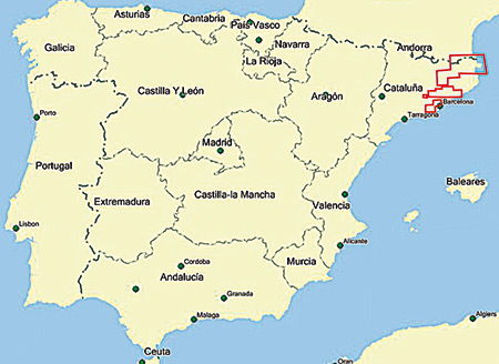
Topo Alpina España – Catalunya Interior-Litoral

coverage:

more manufacturers info:
Download
Thx to Ballebar
- Features raster maps of Serra de Collserola, Massís del Garraf, Montserrat, Montseny, Montnegre-Corredor, Cingles del Bertí, Sant Llorenç del Munt, Granollers, Farell, Mogent a la Calma, Alt Empordà, Osona Nord, Puigsacalm and Garrotxa.
- Displays detailed digital elevation model.
- Features automatic routing on the entire road and trail network.
- Includes searchable points of interest for recreational activities, business and traveling.
- Features data from the popular Editorial Alpina map publisher.
coverage:
more manufacturers info:
- Code:
https://buy.garmin.com/shop/shop.do?cID=255&pID=90086
Download
- hoster: NETuploaded.com & uploaded.net
- link format: single links
- JDownloader or Cryptload recommended
- download size: 1x 299MB + 1x 168MB
- archive format: multipart RAR archive
Thx to Ballebar
Topo Alpina España – Mallorca (Tramuntana)
Mon Aug 20, 2012 9:22 pm
Topo Alpina España – Mallorca (Tramuntana)

coverage:

more manufacturers info:
Download
Thx to Ballebar
- Provides raster maps of Sierra de Tramuntana, Mallorca in 1:25,000 scale, and Mallorca Senderista in 1:50,000 scale.
- Features data from the popular Editorial Alpina map publisher.
- Displays detailed digital elevation model.
- Features A-to-B automatic routing on the entire road and trail network.
- Includes searchable points of interest for recreational activities, business and traveling.
coverage:
more manufacturers info:
- Code:
https://buy.garmin.com/shop/shop.do?cID=255&pID=90084
Download
- hoster: NETuploaded.com & uploaded.net
- link format: single links
- JDownloader or Cryptload recommended
- download size: 1x 145.9MB
- archive format: RAR archive
Thx to Ballebar
Topo Alpina España – Sistema Central - Picos
Mon Aug 20, 2012 9:27 pm
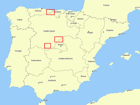
Topo Alpina España – Sistema Central - Picos

coverage:

more manufacturers info:
Download
Thx to Ballebar
- Provides raster maps for Picos de Europa, East and West in 1:40.000 scale.
- Provides raster maps for Sierra de Gredos, Sierra de Guadarrama and La Pedriza in 1:25,000 scale.
- Features data from the popular Editorial Alpina map publisher.
- Displays detailed digital elevation model.
- Features A-to-B automatic routing on the entire road and trail network.
- Includes searchable points of interest for recreational activities, business and traveling.
coverage:
more manufacturers info:
- Code:
https://buy.garmin.com/shop/shop.do?cID=255&pID=90075
Download
- hoster: NETuploaded.com & uploaded.net
- link format: single links
- JDownloader or Cryptload recommended
- download size: 1x 188.5MB
- archive format: RAR archive
Thx to Ballebar
Mon Aug 20, 2012 11:08 pm
UnLocked:
[Please Register or Login to download file]
[Please Register or Login to download file]
[Please Register or Login to download file]
[Please Register or Login to download file]
[Please Register or Login to download file]
[Please Register or Login to download file]
Locked
[Please Register or Login to download file]
[Please Register or Login to download file]
[Please Register or Login to download file]
[Please Register or Login to download file]
[Please Register or Login to download file]
[Please Register or Login to download file]
[Please Register or Login to download file]
[Please Register or Login to download file]
[Please Register or Login to download file]
[Please Register or Login to download file]
[Please Register or Login to download file]
Locked
[Please Register or Login to download file]
[Please Register or Login to download file]
[Please Register or Login to download file]
[Please Register or Login to download file]
[Please Register or Login to download file]
Fri Aug 24, 2012 5:18 pm
Hi,
Those Garmin Topo Alpina Spain series are a real shame !
Based on scanned paper map from imprecised spanish cartography Alpina, they can show positioning errors up to 100 m !
Let’s have a look to that :
4614
On the Basecamp picture up, I drew a route in Topo Alpina Espana (Andalousie)(in purple) that I displayed in Topo Spain v4 in which the corresponding road is yellow. You can see positionning errors up to 100 m !
It is not really worth downloading them even for free.
How can Garmin sell such imprecise maps so expensive ?
Wed Oct 17, 2012 2:48 pm
Van Perfect, I made this Sunday a route Espot and recording with the leading gps topo maps v6 Pyrenees, and on Tuesday I vaje these maps and check them faithfully followed the path of the bullet paths --- Alpine edited by mod: - -
Mon Jan 07, 2013 2:45 pm
Necesita contraseña para descomprimir el fichero. Cual es???
Wed Jan 09, 2013 7:58 pm
The links in the first post have no password. The second post have this: password: ozboss18
Fri May 17, 2013 2:49 pm
i just download the Alpina Central. The name is "TopoAlpinaEspana_SistemaCentral.IMG". When I try to use Map Set Tool Kit it say: the file .IMG need to be 8 digit. Could somebody help me to install ?
Thanks
Thanks
Fri May 17, 2013 3:17 pm
What Do you want to do with MapSetToolkit? This is a map image in raster format for using with current Garmin outdoor devices. It also can be displayed in BaseCamp from removable drive (connected Garmin unit, SD card, USB stick or virtual drive).