
 Forum
Forum
Get More Detail
Outdoor enthusiasts: your adventure is waiting - in vivid detail. TOPO U.S. 24K Northeast brings you the highest level of topographic detail available, with maps comparable to 1:24,000 scale USGS maps. These highly detailed maps on DVD include terrain contours, topo elevations, summits, routable roads and trails, parks, coastlines, rivers, lakes and geographical points - and they also display 3-D terrain shading on compatible devices. With routable roads and trails in metropolitan and rural areas, getting to your destination is easy by creating point-to-point routes on compatible units.
Get More Coverage
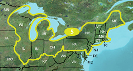
This DVD includes an even larger coverage area than our preprogrammed microSD™/SD™ cards. With this purchase, you'll receive topographic detail for Wisconsin, Michigan, Illinois, Indiana, Ohio, Pennsylvania, New Jersey, New York, Connecticut, Rhode Island, Massachusetts, Vermont, New Hampshire and Maine. You'll also receive BaseCamp™ software for managing data on your device and computer, playing back routes and tracks, geotagging photos and more.
Click the Products tab to see whether this map is compatible with your Garmin device¹.
¹Not all features of this map will work with nüvi® devices. See our FAQ for details.
Features
- Includes topographic coverage of Wisconsin, Michigan, Illinois, Indiana, Ohio, Pennsylvania, New Jersey, New York, Connecticut, Rhode Island, Massachusetts, Vermont, New Hampshire and Maine.
- Provides detailed digital topographic maps, comparable to 1:24,000 scale USGS maps.
- Contains detailed hydrographic features, including coastlines, lake and river shorelines, wetlands and perennial and seasonal streams.
- Allows you to search by points of interest, including cities, summits, lakes, campsites and more.
- Provides elevation profile on compatible Garmin devices so you can estimate terrain difficulty.
- Contains many routable trails, rural roads, city neighborhood roads, major highways and interstates.
- Displays national, state and local parks, forests, conservation areas and wilderness areas.
- Includes points of interests such as parks, campgrounds, scenic lookouts and picnic sites.
- Displays Bureau of Land Management township, range and section information and USGS quad locations.
- Includes BaseCamp software for managing data on GPS and computer, playing back routes and tracks, geotagging photos and more.
Spoiler: Show
Spoiler: Show
Spoiler: Show
Maps are NOT locked.
[Please Register or Login to download file]
All question in General Discussions about Garmin, thanks :-)


