Garmin VEU709L South Norway (v11.50)   

Garmin VEU709L South Norway (v11.50)

Postby huntsman » Fri Jan 28, 2011 11:26 am

[SIZE="4"]Garmin VEU709L - South Norway v2011.5 (v13.00)[/size]
Version: 2011.5
Released: Aug, 2011
Part Number: 010-C0856-00 (microSD/SD), 010-D0504-00 (Download)

[Please Register or Login to download file]
[Please Register or Login to download file]
[Please Register or Login to download file]
[Please Register or Login to download file]
[Please Register or Login to download file]
[Please Register or Login to download file]
[Please Register or Login to download file]
[Please Register or Login to download file]

Image
thanks Ballebar

Code: Select all
https://buy.garmin.com/shop/shop.do?pID=8827
huntsman offline


User avatar Elite Member


Joined: Fri Sep 17, 2010 8:58 pm
Posts: 970
Has thanked: 2 times
Been thanked: 1295 times

BlueChart g2 Vision: VEU016R - Mediterranean Southeast v11.5

Postby PiEtU » Sat May 14, 2011 10:58 pm

[SIZE="4"]BlueChart g2 Vision: VEU016R - Mediterranean Southeast v11.50[/size]
Credits to [color="sienna"]Ballebar[/color]

Features:
  • Includes realistic navigation features showing everything from shaded depth contours and coastlines to spot soundings, navaids, port plans, wrecks, obstructions, intertidal zones, restricted areas, IALA symbols and more.
  • Features smooth displays, including seamless transitions between zoom levels and more continuity across chart boundaries.
  • Includes high-resolution satellite imagery, when overlaid on the chart, provides the mariner with a realistic view of the land and water for unparalleled situational awareness.
  • Features aerial “real world” photos of ports, harbors, marinas, waterways, navigational landmarks and other points of interest, offering the mariner another powerful tool for navigating unfamiliar waters.
  • Includes Auto Guidance technology that searches chart data - tides, currents, marine services, coastal roads and points of interest - to suggest the best passage to a destination.
  • Offers MarinerEye view 3-D perspective, providing a bird's eye view from behind the boat showing the chart information for a quick, reliable and easy position fix.
  • Offers FishEye view 3-D perspective, providing an underwater view that visually represents the sea floor according to the chart's information.
  • Provides Safety Shading (in compatible units), allowing mariners to enable contour shading for all depth contours shallower than user-defined safe depths.
  • Provides Fishing Charts (in compatible units), allowing mariners to scope out bottom contours and depth soundings with less visual clutter on the display.
  • Allows users to conveniently plan and organize routes, from your computer, before your trip with HomePort™, compatible trip-planning software (sold separately).
Coverage:
From Güllük, Turkey east to include Cyprus, Syria, Lebanon and Israel, then west to Misratah, Libya.

[SIZE="3"][Please Register or Login to download file] [/size] (439.51)
Pass: [color="sienna"]navitotal[/color]

MapID: [color="sienna"]2026[/color]

Make .UNL file with JetMouse KeyGen
or
Or make full UnLocked Image Garmin UnLocker Alternative v6.02 (05.04.2011)


[Please Register or Login to download file]
Image
PiEtU offline


User avatar Elite Member


Joined: Sat Feb 13, 2010 9:59 pm
Posts: 929
Location: Pitcairn Islands
Has thanked: 0 time
Been thanked: 157 times
Age: 58

BlueChart g2 vision VEU713L - Finland v11.50

Postby PiEtU » Tue Jul 19, 2011 11:27 pm

BlueChart g2 Vision - VEU713L – Finland 2012.5 v14.00
Version: 2012.5
Released: Aug, 2012
Part numbers: 010-D0508-00 (Download) 010-C0860-00 (microSD/SD)

[Please Register or Login to download file]

See your vessel’s precise, on-chart position in relation to navaids, coastal features, restricted areas and more with premium features found in this detailed marine mapping data. Includes all of the BlueChart® g2 features, plus 3-D perspective above and below the waterline, Auto Guidance, high-resolution imagery, and aerial photos of ports, harbors, marinas, landmarks and other points of interest.

  • Includes realistic navigation features showing everything from shaded depth contours and coastlines to spot soundings, navaids, port plans, wrecks, obstructions, intertidal zones, restricted areas, IALA symbols and more.
  • Features smooth displays, including seamless transitions between zoom levels and more continuity across chart boundaries.
  • Includes high-resolution satellite imagery, when overlaid on the chart, provides the mariner with a realistic view of the land and water for unparalleled situational awareness.
  • Features aerial “real world” photos of ports, harbors, marinas, waterways, navigational landmarks and other points of interest, offering the mariner another powerful tool for navigating unfamiliar waters.
  • Includes Auto Guidance technology that searches chart data - tides, currents, marine services, coastal roads and points of interest - to suggest the best passage to a destination.
  • Offers MarinerEye view 3-D perspective, providing a bird's eye view from behind the boat showing the chart information for a quick, reliable and easy position fix.
  • Offers FishEye view 3-D perspective, providing an underwater view that visually represents the sea floor according to the chart's information.
  • Provides Safety Shading (in compatible units), allowing mariners to enable contour shading for all depth contours shallower than user-defined safe depths.
  • Provides Fishing Charts (in compatible units), allowing mariners to scope out bottom contours and depth soundings with less visual clutter on the display.
  • Allows users to conveniently plan and organize routes, from your computer, before your trip with HomePort™, compatible trip-planning software (sold separately).
Detailed coverage of the Finnish coast along the Gulf of Bothnia and into the Gulf of Finland. Coverage extends from Tornio, Fin. to Vyborg, Rus., including Oulu, Turku, Helsinki, and Kotka in Finland, as well as Hailuoto and Vallgrund. Coverage also includes detail of inland Finnish lakes including Inarijarvi, Miekojarvi, Simojarvi, Kiantajarvi, and Lohjanjarvi. Also includes detailed coverage of Oulujarvi, Pielinen, Saimaa, Paijanne, Nasijarvi, and others. General coverage of the Estonian and Russian coasts along the Gulf of Finland.

MapID: [color="#800000"]2657[/color]

Download
This board requires you to be registered and logged-in to view hidden content.

Code: Select all
https://buy.garmin.com/shop/shop.do?pID=9257
PiEtU offline


User avatar Elite Member


Joined: Sat Feb 13, 2010 9:59 pm
Posts: 929
Location: Pitcairn Islands
Has thanked: 0 time
Been thanked: 157 times
Age: 58

BlueChart g2 Vision - VEU488S - Keitele-Paijanne-Tampere

Postby huntsman » Thu Jan 05, 2012 8:51 am

BlueChart g2 Vision - VEU488S-Keitele-Paijanne-Tampere v2012.5 (v14.00)
Version: 2012.5
Released: Aug, 2012
Part Number: 010-C0832-00 (microSD/SD), 010-D0422-00 (Download)

[Please Register or Login to download file]

See your vessel’s precise, on-chart position in relation to navaids, coastal features, restricted areas and more with premium features found in this detailed marine mapping data. Includes all of the BlueChart® g2 features, plus 3-D perspective above and below the waterline, Auto Guidance, high-resolution imagery, and aerial photos of ports, harbors, marinas, landmarks and other points of interest.

  • Includes realistic navigation features showing everything from shaded depth contours and coastlines to spot soundings, navaids, port plans, wrecks, obstructions, intertidal zones, restricted areas, IALA symbols and more.
  • Features smooth displays, including seamless transitions between zoom levels and more continuity across chart boundaries.
  • Includes high-resolution satellite imagery, when overlaid on the chart, provides the mariner with a realistic view of the land and water for unparalleled situational awareness.
  • Features aerial “real world” photos of ports, harbors, marinas, waterways, navigational landmarks and other points of interest, offering the mariner another powerful tool for navigating unfamiliar waters.
  • Includes Auto Guidance technology that searches chart data - tides, currents, marine services, coastal roads and points of interest - to suggest the best passage to a destination.
  • Offers MarinerEye view 3-D perspective, providing a bird's eye view from behind the boat showing the chart information for a quick, reliable and easy position fix.
  • Offers FishEye view 3-D perspective, providing an underwater view that visually represents the sea floor according to the chart's information.
  • Provides Safety Shading (in compatible units), allowing mariners to enable contour shading for all depth contours shallower than user-defined safe depths.
  • Provides Fishing Charts (in compatible units), allowing mariners to scope out bottom contours and depth soundings with less visual clutter on the display.
  • Allows users to conveniently plan and organize routes, from your computer, before your trip with HomePort™, compatible trip-planning software (sold separately).
Detailed coverage of inland Finnish lakes including Keitele, Puula, and Paijanne. Also includes detailed coverage of Ahtarinjarvi, Nasijarvi, Pyhajarvi, and Lohjanjarvi.

MapID: [color="#800000"]2655[/color]

Download:
This board requires you to be registered and logged-in to view hidden content.

Code: Select all
https://buy.garmin.com/shop/shop.do?pID=9235
huntsman offline


User avatar Elite Member


Joined: Fri Sep 17, 2010 8:58 pm
Posts: 970
Has thanked: 2 times
Been thanked: 1295 times

VEU712L - Sweden East & Gulf of Finland 2012.2

Postby Gmupakap » Sun Jun 10, 2012 7:03 pm

[color="navy"][SIZE="5"]BlueChart G2 Vision VEU712L - Sweden East & Gulf of Finland 2012.2 (v 13.52)[/size][/color]
Baltic Sea, Sweden east coast and Gulf of Finland

Image

locked Image
FID: 2539
Version: 2012.2 (v13.52)
Date: Feb 2012

Code: Select all
https://buy.garmin.com/shop/shop.do?pID=8830&pvID=10450


Download:
Hoster: NETuploaded.com
JDownloader or Cryptload recommended
Download size: 8x 195MB + 1x 154,6MB multivolume ZIP archive
[SPOILER="download links"][Please Register or Login to download file]
[Please Register or Login to download file]
[Please Register or Login to download file]
[Please Register or Login to download file]
[Please Register or Login to download file]
[Please Register or Login to download file]
[Please Register or Login to download file]
[Please Register or Login to download file]
[Please Register or Login to download file] [/spoiler]

Thx to Pietu!
Gmupakap offline


User avatar Junior Member


Joined: Fri Jan 27, 2012 5:42 pm
Posts: 54
Has thanked: 9 times
Been thanked: 24 times

VEU716L - Mediterranean Central 2012.1

Postby Gmupakap » Sun Jun 10, 2012 7:12 pm

[color="navy"][SIZE="5"]BlueChart G2 Vision VEU716L - Mediterranean Central 2012.1 (v13.51)[/size][/color]

4332

locked Image
FID: 2539
Version: 2012.1 (v13.51)
Date: 13.02.2012
Image size: 2,53GB

Code: Select all
https://buy.garmin.com/shop/shop.do?pID=9260&pvID=10876


Download:
Hoster: netuploaded.com
JDownloader or Cryptload recommended
Download size: 12x 200MB + 30,7MB RAR files
[SPOILER="download links"]
[Please Register or Login to download file]
[Please Register or Login to download file]
[Please Register or Login to download file]
[Please Register or Login to download file]
[Please Register or Login to download file]
[Please Register or Login to download file]
[Please Register or Login to download file]
[Please Register or Login to download file]
[Please Register or Login to download file]
[Please Register or Login to download file]
[Please Register or Login to download file]
[Please Register or Login to download file]
[Please Register or Login to download file]
[/spoiler]


Thx to Ballebar
Gmupakap offline


User avatar Junior Member


Joined: Fri Jan 27, 2012 5:42 pm
Posts: 54
Has thanked: 9 times
Been thanked: 24 times

BlueChart g2 Vision - VEU713L – Finland

Postby huntsman » Tue Jun 12, 2012 5:33 am

BlueChart g2 Vision - VEU713L – Finland 2012.5 v14.00
Version: 2012.5
Released: Aug, 2012
Part numbers: 010-D0508-00 (Download) 010-C0860-00 (microSD/SD)

[Please Register or Login to download file]

See your vessel’s precise, on-chart position in relation to navaids, coastal features, restricted areas and more with premium features found in this detailed marine mapping data. Includes all of the BlueChart® g2 features, plus 3-D perspective above and below the waterline, Auto Guidance, high-resolution imagery, and aerial photos of ports, harbors, marinas, landmarks and other points of interest.

  • Includes realistic navigation features showing everything from shaded depth contours and coastlines to spot soundings, navaids, port plans, wrecks, obstructions, intertidal zones, restricted areas, IALA symbols and more.
  • Features smooth displays, including seamless transitions between zoom levels and more continuity across chart boundaries.
  • Includes high-resolution satellite imagery, when overlaid on the chart, provides the mariner with a realistic view of the land and water for unparalleled situational awareness.
  • Features aerial “real world” photos of ports, harbors, marinas, waterways, navigational landmarks and other points of interest, offering the mariner another powerful tool for navigating unfamiliar waters.
  • Includes Auto Guidance technology that searches chart data - tides, currents, marine services, coastal roads and points of interest - to suggest the best passage to a destination.
  • Offers MarinerEye view 3-D perspective, providing a bird's eye view from behind the boat showing the chart information for a quick, reliable and easy position fix.
  • Offers FishEye view 3-D perspective, providing an underwater view that visually represents the sea floor according to the chart's information.
  • Provides Safety Shading (in compatible units), allowing mariners to enable contour shading for all depth contours shallower than user-defined safe depths.
  • Provides Fishing Charts (in compatible units), allowing mariners to scope out bottom contours and depth soundings with less visual clutter on the display.
  • Allows users to conveniently plan and organize routes, from your computer, before your trip with HomePort™, compatible trip-planning software (sold separately).
Detailed coverage of the Finnish coast along the Gulf of Bothnia and into the Gulf of Finland. Coverage extends from Tornio, Fin. to Vyborg, Rus., including Oulu, Turku, Helsinki, and Kotka in Finland, as well as Hailuoto and Vallgrund. Coverage also includes detail of inland Finnish lakes including Inarijarvi, Miekojarvi, Simojarvi, Kiantajarvi, and Lohjanjarvi. Also includes detailed coverage of Oulujarvi, Pielinen, Saimaa, Paijanne, Nasijarvi, and others. General coverage of the Estonian and Russian coasts along the Gulf of Finland.

MapID: [color="#800000"]2657[/color]

Download
This board requires you to be registered and logged-in to view hidden content.

Code: Select all
https://buy.garmin.com/shop/shop.do?pID=9257
huntsman offline


User avatar Elite Member


Joined: Fri Sep 17, 2010 8:58 pm
Posts: 970
Has thanked: 2 times
Been thanked: 1295 times

Postby huntsman » Tue Jun 12, 2012 7:28 am

BlueChart g2 Vision - VEU712L - Sweden East & Gulf of Finland (v13.52)
Version: 2012.2
Released: Feb, 2012
Part Number: 010-D0507-00

See your vessel’s precise, on-chart position in relation to navaids, coastal features, restricted areas and more with premium features found in this detailed marine mapping data. Includes all of the BlueChart® g2 features, plus 3-D perspective above and below the waterline, Auto Guidance, high-resolution imagery, and aerial photos of ports, harbors, marinas, landmarks and other points of interest
  • Includes realistic navigation features showing everything from shaded depth contours and coastlines to spot soundings, navaids, port plans, wrecks, obstructions, intertidal zones, restricted areas, IALA symbols and more.
  • Features smooth displays, including seamless transitions between zoom levels and more continuity across chart boundaries.
  • Includes high-resolution satellite imagery, when overlaid on the chart, provides the mariner with a realistic view of the land and water for unparalleled situational awareness.
  • Features aerial “real world” photos of ports, harbors, marinas, waterways, navigational landmarks and other points of interest, offering the mariner another powerful tool for navigating unfamiliar waters.
  • Includes Auto Guidance technology that searches chart data - tides, currents, marine services, coastal roads and points of interest - to suggest the best passage to a destination.
  • Offers MarinerEye view 3-D perspective, providing a bird's eye view from behind the boat showing the chart information for a quick, reliable and easy position fix.
  • Offers FishEye view 3-D perspective, providing an underwater view that visually represents the sea floor according to the chart's information.
  • Provides Safety Shading (in compatible units), allowing mariners to enable contour shading for all depth contours shallower than user-defined safe depths.
  • Provides Fishing Charts (in compatible units), allowing mariners to scope out bottom contours and depth soundings with less visual clutter on the display.
  • Allows users to conveniently plan and organize routes, from your computer, before your trip with HomePort™, compatible trip-planning software (sold separately).

Detailed coverage of the coast of Sweden along the Baltic Sea and Gulf of Bothnia from Trelleborg to Haparanda including Kristianstad, Stockholm, Sundsvall, and Luleå; also coastal coverage of Finland's Gulf of Finland from Uusikaupunki to Vyborg including Turku, Hanko, and Helsinki. Swedish lake coverage features Vättern, Sommen, Nommen, Revsundssjön, Hjälmaren, Mälaren, Storsjön, Storavan, Uddjaur, Hornovan, Tjeggelvas, Aisjaur, Fluka, Helgasjön, and Bolmen, as well as coverage of the lower Dalälven from Gysinge to Söderfors. Island coverage features Bornholm, Oland, Gotland, and Åland. Coverage does not include the St. Petersburg region or any Russian waters.

[Please Register or Login to download file] Image

MapID: [color="#800000"]2539[/color]


Code: Select all
https://buy.garmin.com/shop/shop.do?pID=8830


Image
huntsman offline


User avatar Elite Member


Joined: Fri Sep 17, 2010 8:58 pm
Posts: 970
Has thanked: 2 times
Been thanked: 1295 times

BlueChart g2 Vision: VEU014R-Italy Adriatic Sea

Postby jenas » Thu Jun 21, 2012 4:36 pm

Garmin VEU014R-Italy, Adriatic Sea Bluechart G2 Vision (10.50)

MapID: 490, unlocked map

[Please Register or Login to download file]
[Please Register or Login to download file]

or

[Please Register or Login to download file]
[Please Register or Login to download file]


--- supplement by mod ---
Please keep this offer thread clear and ask your questions to bluechart maps >>>here
jenas offline


Junior Member


Joined: Thu Jul 01, 2010 3:35 pm
Posts: 76
Has thanked: 6 times
Been thanked: 3 times

BlueChart G2Vision - Seamaps Europe

Postby Gmupakap » Sun Jun 24, 2012 6:01 pm

[color="navy"][SIZE="5"]BlueChart G2 Vision VEU711L - Sweden South 2012.2 (v13.52)[/size][/color]

Image

locked Image
FID: 2539
Version: 2012.2 (v13.52)
Release Date: Feb 2012

Code: Select all
https://buy.garmin.com/shop/shop.do?pID=8829&pvID=10449


Download:
Hoster: Uploaded.to & NETuploaded.com
JDownloader or Cryptload recommended
Download size: 9x 200MB + 1x 40.3MB multivolume RAR archive
[SPOILER="download links"][Please Register or Login to download file]
[Please Register or Login to download file]
[Please Register or Login to download file]
[Please Register or Login to download file]
[Please Register or Login to download file]
[Please Register or Login to download file]
[Please Register or Login to download file]
[Please Register or Login to download file]
[Please Register or Login to download file]
[Please Register or Login to download file]

Mirror:
[Please Register or Login to download file]
[Please Register or Login to download file]
[Please Register or Login to download file]
[Please Register or Login to download file]
[Please Register or Login to download file]
[Please Register or Login to download file]
[Please Register or Login to download file]
[Please Register or Login to download file]
[Please Register or Login to download file]
[Please Register or Login to download file] [/spoiler]

Thx to Ballebar!


--- supplement by mod ---
Please keep this offer thread clear and ask your questions to bluechart maps >>>here
Gmupakap offline


User avatar Junior Member


Joined: Fri Jan 27, 2012 5:42 pm
Posts: 54
Has thanked: 9 times
Been thanked: 24 times

BlueChart g2 Vision: VEU710L - Denmark, Skagerrak & Kattegat

Postby bam-bam » Thu Jul 05, 2012 3:34 pm

BlueChart g2 Vision: VEU710L - Denmark, Skagerrak & Kattegat v2012.2 (v13.52)

info:
Code: Select all
https://buy.garmin.com/shop/shop.do?pID=8828


Version: 2012.2
Released: Feb, 2012
Part Number: 010-C0857-00 (microSD/SD), 010-D0505-00 (Download)

See your vessel’s precise, on-chart position in relation to navaids, coastal features, restricted areas and more with premium features found in this detailed marine mapping data. Includes all of the BlueChart® g2 features, plus 3-D perspective above and below the waterline, Auto Guidance, high-resolution imagery, and aerial photos of ports, harbors, marinas, landmarks and other points of interest.

Features
Includes realistic navigation features showing everything from shaded depth contours and coastlines to spot soundings, navaids, port plans, wrecks, obstructions, intertidal zones, restricted areas, IALA symbols and more.
Features smooth displays, including seamless transitions between zoom levels and more continuity across chart boundaries.
Includes high-resolution satellite imagery, when overlaid on the chart, provides the mariner with a realistic view of the land and water for unparalleled situational awareness.
Features aerial “real world” photos of ports, harbors, marinas, waterways, navigational landmarks and other points of interest, offering the mariner another powerful tool for navigating unfamiliar waters.
Includes Auto Guidance technology that searches chart data - tides, currents, marine services, coastal roads and points of interest - to suggest the best passage to a destination.
Offers MarinerEye view 3-D perspective, providing a bird's eye view from behind the boat showing the chart information for a quick, reliable and easy position fix.
Offers FishEye view 3-D perspective, providing an underwater view that visually represents the sea floor according to the chart's information.
Provides Safety Shading (in compatible units), allowing mariners to enable contour shading for all depth contours shallower than user-defined safe depths.
Provides Fishing Charts (in compatible units), allowing mariners to scope out bottom contours and depth soundings with less visual clutter on the display.
Allows users to conveniently plan and organize routes, from your computer, before your trip with HomePort™, compatible trip-planning software (sold separately).
.


Coverage Details

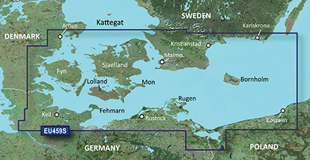
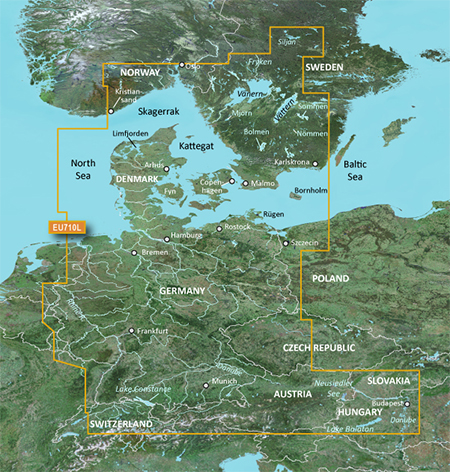
Detailed coverage of Denmark in its entirety including Limfjorden, Århus, and Copenhagen, as well as southern portions of Norway and Sweden, from Kristiansand, Nor. to Karlskrona, Swe., including Oslo, Nor., and Malmo and Trelleborg, Swe. and lakes Vänern, Vättern, Mjörn, Sommen, Nommen, and Bolmen. Coverage also includes Bremen and Hamburg from Germany's North Sea coast, as well as Rostock and Rügen, Ger., and Scezcin, Pol. along the Baltic Coast.


Image


locked image
PID 1, FID 2539, region 4,1


Code: Select all
[url]http://www.mirrorcreator.com/files/12M187DZ/VEU710L_v1352.part1.rar_links[/url]
[url]http://www.mirrorcreator.com/files/10OKUBQ5/VEU710L_v1352.part2.rar_links[/url]
[url]http://www.mirrorcreator.com/files/08QTJBLF/VEU710L_v1352.part3.rar_links[/url]
[url]http://www.mirrorcreator.com/files/VRZOSLPX/VEU710L_v1352.part4.rar_links[/url]
[url]http://www.mirrorcreator.com/files/1E1QF4MX/VEU710L_v1352.part5.rar_links[/url]
[url]http://www.mirrorcreator.com/files/0NTPBDB3/VEU710L_v1352.part6.rar_links[/url]


Thanks to Ballebar


--- supplement by mod ---
Please keep this offer thread clear and ask your questions to bluechart maps >>>here
bam-bam offline


User avatar Ex Moderator


Joined: Fri Jul 23, 2010 9:43 pm
Posts: 1420
Location: .BG
Has thanked: 51 times
Been thanked: 2004 times
Age: 44

BlueChart g2 Vision: VEU015R - Aegean Sea & Sea of Marmara v

Postby bam-bam » Wed Aug 01, 2012 10:37 pm

Image


info:
Code: Select all
https://buy.garmin.com/shop/shop.do?pID=9192


Version: 2011.5
Released: Aug, 2011

See your vessel’s precise, on-chart position in relation to navaids, coastal features, restricted areas and more with premium features found in this detailed marine mapping data. Includes all of the BlueChart® g2 features, plus 3-D perspective above and below the waterline, Auto Guidance, high-resolution imagery, and aerial photos of ports, harbors, marinas, landmarks and other points of interest.

Features
Includes realistic navigation features showing everything from shaded depth contours and coastlines to spot soundings, navaids, port plans, wrecks, obstructions, intertidal zones, restricted areas, IALA symbols and more.
Features smooth displays, including seamless transitions between zoom levels and more continuity across chart boundaries.
Includes high-resolution satellite imagery, when overlaid on the chart, provides the mariner with a realistic view of the land and water for unparalleled situational awareness.
Features aerial “real world” photos of ports, harbors, marinas, waterways, navigational landmarks and other points of interest, offering the mariner another powerful tool for navigating unfamiliar waters.
Includes Auto Guidance technology that searches chart data - tides, currents, marine services, coastal roads and points of interest - to suggest the best passage to a destination.
Offers MarinerEye view 3-D perspective, providing a bird's eye view from behind the boat showing the chart information for a quick, reliable and easy position fix.
Offers FishEye view 3-D perspective, providing an underwater view that visually represents the sea floor according to the chart's information.
Provides Safety Shading (in compatible units), allowing mariners to enable contour shading for all depth contours shallower than user-defined safe depths.
Provides Fishing Charts (in compatible units), allowing mariners to scope out bottom contours and depth soundings with less visual clutter on the display.
Allows users to conveniently plan and organize routes, from your computer, before your trip with HomePort™, compatible trip-planning software (sold separately).
.


Coverage Details

Including all of the Greek coast and Aegean Sea; Turkey from Istanbul and Sea of Marmara to Antalya; and Brindisi, Italy.


Image


locked img

Code: Select all
[url]http://mir.cr/EAVG4QLH[/url]
[url]http://mir.cr/16IANETY[/url]
[url]http://mir.cr/06QDTPVZ[/url]
[url]http://mir.cr/ZAOVSFHT[/url]
[url]http://mir.cr/JYO41PYM[/url]
[url]http://mir.cr/0UVFLZHU[/url]
[url]http://mir.cr/ATHXZD6Q[/url]


thanks to ballebar


--- supplement by mod ---
Please keep this offer thread clear and ask your questions to bluechart maps >>>here
bam-bam offline


User avatar Ex Moderator


Joined: Fri Jul 23, 2010 9:43 pm
Posts: 1420
Location: .BG
Has thanked: 51 times
Been thanked: 2004 times
Age: 44

BlueChart g2 Vision - VEU047R - Gulf of Bothnia-Kalix-Grissl

Postby huntsman » Wed Aug 22, 2012 7:29 pm

BlueChart g2 Vision - VEU047R - Gulf of Bothnia-Kalix-Grisslehamn v2012.5 (14.00)
Version: 2012.5
Released: Aug, 2012
Part Number: 010-D0453-00

[Please Register or Login to download file]

See your vessel’s precise, on-chart position in relation to navaids, coastal features, restricted areas and more with premium features found in this detailed marine mapping data. Includes all of the BlueChart® g2 features, plus 3-D perspective above and below the waterline, Auto Guidance, high-resolution imagery, and aerial photos of ports, harbors, marinas, landmarks and other points of interest.

  • Includes realistic navigation features showing everything from shaded depth contours and coastlines to spot soundings, navaids, port plans, wrecks, obstructions, intertidal zones, restricted areas, IALA symbols and more.
  • Features smooth displays, including seamless transitions between zoom levels and more continuity across chart boundaries.
  • Includes high-resolution satellite imagery, when overlaid on the chart, provides the mariner with a realistic view of the land and water for unparalleled situational awareness.
  • Features aerial “real world” photos of ports, harbors, marinas, waterways, navigational landmarks and other points of interest, offering the mariner another powerful tool for navigating unfamiliar waters.
  • Includes Auto Guidance technology that searches chart data - tides, currents, marine services, coastal roads and points of interest - to suggest the best passage to a destination.
  • Offers MarinerEye view 3-D perspective, providing a bird's eye view from behind the boat showing the chart information for a quick, reliable and easy position fix.
  • Offers FishEye view 3-D perspective, providing an underwater view that visually represents the sea floor according to the chart's information.
  • Provides Safety Shading (in compatible units), allowing mariners to enable contour shading for all depth contours shallower than user-defined safe depths.
  • Provides Fishing Charts (in compatible units), allowing mariners to scope out bottom contours and depth soundings with less visual clutter on the display.
  • Allows users to conveniently plan and organize routes, from your computer, before your trip with HomePort™, compatible trip-planning software (sold separately).
Detailed coverage of the Gulf of Bothnia frome Gavle, Sweden through Pori, Finland, including Oulu and Vaasa, Fin. Sweden coverage includes Luleå Skärgård, and lakes Tjeggelvas, Hornavan, Aisjaur, Fluka, Uddjaur, Storavan, Revsundssjön and Storsjön well as coverage of the lower Dalälven from Gysinge to Söderfors. Detailed coverage of the islands of Hailuoto, Vallgrund, and Åland is also included.

MapID: [color="#800000"]2656[/color]

Download:
Code: Select all
 
Locked Image
[URL=http://netload.in/dateipgRkmD4DL4/VEU047R-L.part1.rar.htm]Download Part1[/URL]
[URL=http://netload.in/dateipISNrDKnJN/VEU047R-L.part2.rar.htm]Download Part2[/URL]
[URL=http://netload.in/dateiTHLDXN0A4e/VEU047R-L.part3.rar.htm]Download Part3[/URL]
[URL=http://netload.in/dateiEe1MYwUDWW/VEU047R-L.part4.rar.htm]Download Part4[/URL]

UnLocked Image
[URL=http://netload.in/dateisLLIZSUdhq/VEU047R-UL.part1.rar.htm]Download Part1[/URL]
[URL=http://netload.in/dateinOqbAZl9Fw/VEU047R-UL.part2.rar.htm]Download Part2[/URL]
[URL=http://netload.in/dateiBVw28Qsn1L/VEU047R-UL.part3.rar.htm]Download Part3[/URL]
[URL=http://netload.in/dateiaySOUkz49B/VEU047R-UL.part4.rar.htm]Download Part4[/URL]


Code: Select all
https://buy.garmin.com/shop/shop.do?pID=8815
huntsman offline


User avatar Elite Member


Joined: Fri Sep 17, 2010 8:58 pm
Posts: 970
Has thanked: 2 times
Been thanked: 1295 times

Postby bam-bam » Sun Aug 26, 2012 10:11 pm

BlueChart® g2 Vision VEU459S-Arhus-Kiel-Koszalin v2012.5 v.14


Image


FID 2655


Coverage Details

Swedish coast: from Hoganas to Karlskrona, including Malmö. Danish, German, and Polish coasts: from Århus to Koszalin, including Sjælland, Fyn, Møn, Falster, Lolland, Langeland and Fehmarn.


info
Code: Select all
https://buy.garmin.com/shop/shop.do?pID=8822


Code: Select all
File:      VEU459S.img, length 737853440
Header:      05.07.2012 09:31:44, DSKIMG, XOR 00, V 14.00, Ms 0
Mapset:      VEU459S-Arhus-Kiel-Koszalin v2012.5
fat:      1000h - 1200h - 20000h, block 16384
maps:      64, sub-files 65

Sub-file         fat     length
 MARINAS  MDR   1200h    301330
 MARINAS  SRT   1400h       968
 B0000025 GMP   1600h      2551
   GMP:  TRE RGN LBL
   map 10d9ea5 (17669797)
   PID 1, FID 2655, region 5,10
   date 03.07.2012 17:04:13
   priority 28, parameters 1 6 31 3, locked, transparent
   N: 56.337891, S: 53.399048, W: 9.107666, E: 16.715698
   GARMIN G-Map
   Copyright 1995-2012 by GARMIN Corporation.
   CP 1252, Western European


Code: Select all
lock img
part1
[url]https://www.box.com/s/7b5941ec407042d30d43[/url]
part2
[url]https://www.box.com/s/da5c07c85956cda36544[/url]
part3
[url]https://www.box.com/s/391c1d37acfb26292c00[/url]
part4
[url]https://www.box.com/s/5d0051e180277aa915fe[/url]
part5
[url]https://www.box.com/s/d0f408ab781f1b5acdc2[/url]
part6
[url]https://www.box.com/s/6ca78d3142274a818df5[/url]
part7
[url]https://www.box.com/s/4722c0796387f902e7b3[/url]


[url=http://www35.zippyshare.com/v/35150745/file.html]VEU459S.part1.rar[/url]
[url=http://www35.zippyshare.com/v/11778172/file.html]VEU459S.part2.rar[/url]
[url=http://www35.zippyshare.com/v/68221706/file.html]VEU459S.part3.rar[/url]
[url=http://www35.zippyshare.com/v/18078500/file.html]VEU459S.part4.rar[/url]


--- supplement by mod ---
Please keep this offer thread clear and ask your questions to bluechart maps >>>here
bam-bam offline


User avatar Ex Moderator


Joined: Fri Jul 23, 2010 9:43 pm
Posts: 1420
Location: .BG
Has thanked: 51 times
Been thanked: 2004 times
Age: 44


Return to New Maps


  • Related topics
    Replies
    Views
    Last post

Who is online

Users browsing this forum: photon923 and 6 guests