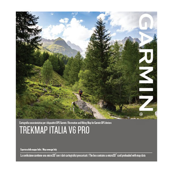
Garmin TrekMap® Italy v6 PRO
Original Locked IMG
All credits to a Friend who wishes to remain anonymous
Garmin presenta
TrekMap® Italy v6 PRO, the map of the trails of the whole of Italy
Upgrade your compatible device with highly-detailed recreational maps of Italy. From the the Alps summits down to the Sicilian beaches, this topographic map — in a reference scale of up to 1:5,000¹ — contains versatile route planning for hiking and climbing.
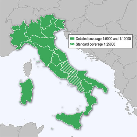
Topographic maps in 1:5,000 and 1:10,000 scale available for these regions: Lombardy, Piedmont, Liguria, Provincia Autonoma di Trento, Veneto, Provincia Autonoma di Bolzano, Friuli Venezia Giulia, Emilia-Romagna, Tuscany, Sardinia, Umbria, Lazio, Calabria, Basilicata, Apulia, Aosta Valley, Marche, Sicily. The remaining regions are covered with standard 1:25,000 topographic maps
Features:- With extended detailed coverage in Aosta Valley, Marche and Sicily.
- Offers the largest recreational trail network for Italy, including the official trails supplied by the Italian Alpine Club (CAI), Regional Tourist Offices, National and Regional Parks, with an extension of approximately 200,000 km.
- Includes the Grand Italian Trail (Sentiero Italia), a more than 6,000 kilometer long hiking trail that crosses the entire national territory of Italy
- Includes ActiveRouting, which allows you to customize and specifically plan routes for the entire road and trail network. The activity specific map displays highlights of suggested routes in addition to dedicated biking and hiking routes.
ActiveRouting functionalities supported by Montana®, GPSMAP® 64/66, Oregon® 6xx/x50, Edge® 8xx/1xxx and many more - Includes searchable addresses with street numbers nationwide.
- Features Digital Elevation Model (DEM) with height contours with a 20 m interval.
CoverageFeatures coverage for all of Italy.
SOLID GREEN geographic area is covered with data in 1:5,000 and 1:10,000 scale supplied by the following Regional Cartography Offices. It includes: Regione Valle d'Aosta, Regione Lombardia, Regione Piemonte, Regione Liguria, Provincia Autonoma di Trento, Regione Veneto, Provincia Autonoma di Bolzano, Regione Friuli Venezia Giulia, Regione Emilia-Romagna, Regione Toscana, Regione Sardegna, Regione Umbria, Regione Marche, Regione Lazio, Regione Calabria, Regione Basilicata, Regione Puglia and Regione Sicily.
DASHED GREEN geographic area is covered with standard 1:25,000 topography detail.
Additional coverage of the Abruzzo is available separately, as a free download.Part Number: 010-D0749-04FID:
8615Info:- Code: Select all
https://buy.garmin.com/en-GB/GB/p/730309#overview
GMapTool Info:- Code: Select all
File:        D:/Garmin/TrekMap Italia v6 Pro/TrekMapItalia_v6_Pro.img, lunghezza 2057895936
Header:       09.06.2020 13:14:47, DSKIMG, XOR 00, V 6.00, Ms 0, 006-D2557-04
Mappa:        TrekMap Italia v6 PRO
fat:        1000h - 1200h - 58000h, blocco 32768
mappe:        246, sub-files 489

Sub-file         fat     lungh.
 00008615 MD2   1200h   1288883
    data 09.06.2020 12:41:25
    000-00000-00
 00008615 MDR   1400h  30347149
    data 09.06.2020 12:40:31, CP 65001
 00008615 SRT   1C00h    201646
 I00021A7 TYP   1E00h    817716
    data 09.06.2020 08:55:40
    CP 65001, PID 1, FID 8615
 I1051CDC GMP   2000h    429257
    GMP: TRE RGN LBL NET NOD DEM
    GMP: data 09.06.2020 08:33:21
    mappa 1051cdc (17112284)
    PID 1, FID 8615, regione 0,0
    TRE: data 09.06.2020 08:33:21
    draw priority 20, parametri 1 4 10 1, [COLOR=#ff0000][B]bloccata[/B][/COLOR], [COLOR=#ff0000][B]firmato[/B][/COLOR]
    N: 45.200028, S: 45.000000, W: 12.269969, E: 12.588916
    TrekMap Italia v6 PRO
    Copyright 1995-2020 by GARMIN Corporation.
    CP 65001, UTF8
    DEM layers: 1, N: 45.200238, W: 12.269839
 I1051CDC SRT   2200h    201646
 I1051CDD GMP   2400h    370646
    GMP: TRE RGN LBL NET NOD DEM
    GMP: data 09.06.2020 08:33:04
    mappa 1051cdd (17112285)
    PID 1, FID 8615, regione 0,0
    TRE: data 09.06.2020 08:33:04
    draw priority 20, parametri 1 4 10 1,[COLOR=#ff0000][B] bloccata[/B][/COLOR], [COLOR=#ff0000][B]firmato[/B][/COLOR]
    N: 45.400014, S: 45.199986, W: 12.269969, E: 12.491412
    TrekMap Italia v6 PRO
    Copyright 1995-2020 by GARMIN Corporation.
    CP 65001, UTF8
    DEM layers: 1, N: 45.400116, W: 12.269839
 I1051CDD SRT   2600h    201646
 I1051CDE GMP   2800h   2880662
    GMP: TRE RGN LBL NET NOD DEM
    GMP: data 09.06.2020 08:36:32
    mappa 1051cde (17112286)
    PID 1, FID 8615, regione 0,0
    TRE: data 09.06.2020 08:36:32
    draw priority 20, parametri 1 4 10 1,[COLOR=#ff0000][B] bloccata[/B][/COLOR], [COLOR=#ff0000][B]firmato[/B][/COLOR]
    N: 45.599999, S: 45.399971, W: 12.269969, E: 12.600031
    TrekMap Italia v6 PRO
    Copyright 1995-2020 by GARMIN Corporation.
    CP 65001, UTF8
    DEM layers: 1, N: 45.600457, W: 12.269839
 I1051CDE SRT   2A00h    201646
 I1051CDF GMP   2C00h   5561906
    GMP: TRE RGN LBL NET NOD DEM
    GMP: data 09.06.2020 08:37:54
    mappa 1051cdf (17112287)
    PID 1, FID 8615, regione 0,0
    TRE: data 09.06.2020 08:37:54
    draw priority 20, parametri 1 4 10 1, [COLOR=#ff0000][B]bloccata[/B][/COLOR], [COLOR=#ff0000][B]firmato[/B][/COLOR]
    N: 44.200015, S: 43.973722, W: 9.411035, E: 9.960008
    TrekMap Italia v6 PRO
    Copyright 1995-2020 by GARMIN Corporation.
    CP 65001, UTF8
    DEM layers: 1, N: 44.200384, W: 9.410933
 I1051CDF SRT   2E00h    201646
 I1051CE0 GMP   3000h     96997
    GMP: TRE RGN LBL NET NOD DEM
    GMP: data 09.06.2020 08:31:57
    mappa 1051ce0 (17112288)
    PID 1, FID 8615, regione 0,0
    TRE: data 09.06.2020 08:31:57
    draw priority 20, parametri 1 4 10 1, [COLOR=#ff0000][B]bloccata[/B][/COLOR], firmato
    N: 42.276936, S: 42.053690, W: 15.424676, E: 15.801129
    TrekMap Italia v6 PRO
    Copyright 1995-2020 by GARMIN Corporation.
    CP 65001, UTF8
    DEM layers: 1, N: 42.277019, W: 15.424398
    ...
Password:
FireFox58TrekMap Abruzzo V6.zip (204 MB): [Please Register or Login to download file]

 Forum
Forum


