GARMIN MAP OF GREECE Arhcaelogical sites,Trails, Roads, For
Sun Jan 08, 2012 2:09 pm
THE MAP IS FREE FOR GARMIN AND NAVITEL
[color="#0000CD"]NEW VERSION UPDATED 2012.01.23[/color]


This map is based on data from [Please Register or Login to download file] and is licensed under the [Please Register or Login to download file] , and contains data from [Please Register or Login to download file] .
ROUTABLE BUT NOT CONTAIN ALL THE ONEWAY STREET DATA
This map is offered in two software/device forms:
For GARMIN software or devices.
Για Navitel software. CAUTION: To work properly the map needs to use Navitel with version 3.2 to 3.5, because newer versions have trouble to open map in nm2 format. This map is exported with GPSMapEdit which can export maps only in this format.
NOTE: multilanguage support is not completed and depends at the data of the map.
[color="#FF0000"]For use directly to your device. You can copy directly to the EXTERNAL memory of your device (important: not directly to the device). If your device is old and does not "see" the map rename the file to "gmapsupp.img" (attention Do NOT OVERWRITE AND not delete your own maps and weep! Will not be my fault.).[/color]
Map for GARMIN
You’ll find it in two versions:
For use directly from your device. You can copy it directly to the memory card of your device (important: not directly to the device). If your device is old and does not “see” the map, rename the file to “gmapsupp.img” (Attention: do not override or delete your own maps (if there is any with this name!.).
Installation for MapSource / BaseCamp. This is an installation file of the map in MapSource. After installation you can uninstall the map through Add or Remove Programs on Windows Control Panel applet.
Current version 2012.01.23:
There are a lot of user updates at every version of this map, but is very difficult to record. Basic or big changes will be presented here.
New in Version 2012.01.23
Archeaoligical sites:
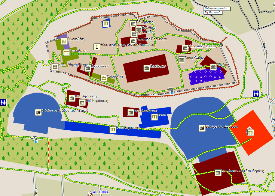
Acropolis of Athens, Ancient Agora of Athens, Zeus Temple.
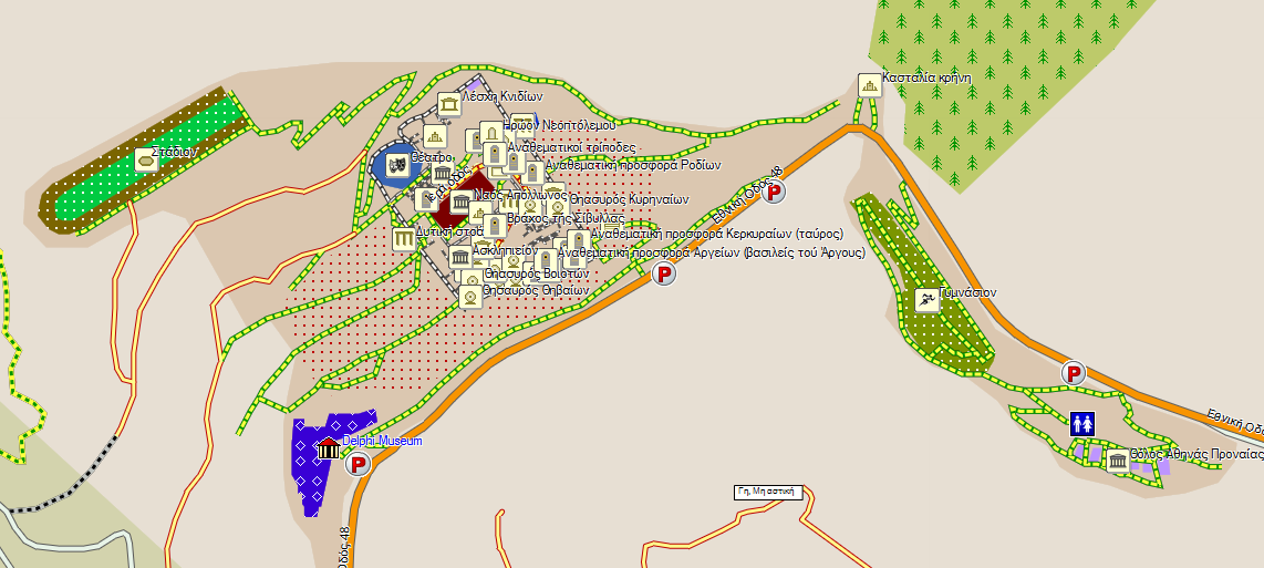
Delphi
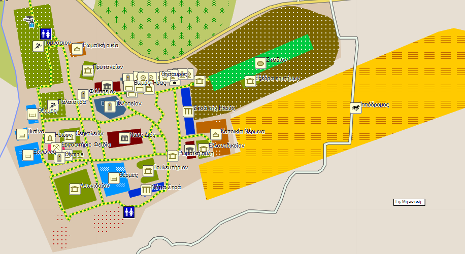
Ancient Olympia
Mycenea
Ancient Korinth, Akrokorinth
Amfiaraion
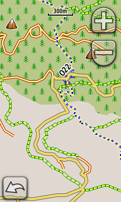
Contours: per 20 meters (65.6 feet), improve, without holes. Smaller file by removing tiles outside Greece. This verion is only for GARMIN. There is another file for Navitel provided by giannis_05. A big THANKS to my friend giannis_05 for his help and his offer to this version.
[Please Register or Login to download file]
[Please Register or Login to download file]
PREVIOUS Version 2012.01.09:
What’s new:
Contours. This is a separate file, because of its size. Thre are contours every 25 meters (82 feet). At some areas of the map the data are not completed so there are some “holes” there.
Map legend (if you install the map for MapSource/BaseCamp) at the start menu of Windows
There is also a map that contains (only) contours every 25 meters (82 feet). This is a separate file because of its size, and it's available for GARMIN and Navitel.
If you install the map to your PC for MapSource/BaseCamp you'll find a shortcut named "Map Legend" at the folder "Nikos Skouteris" under the Windows start menu, that opens a HTML page containing information about the map elements.
[color="#0000FF"]Current version is 2012.01.23[/color]
[Please Register or Login to download file]
[color="#0000CD"][Please Register or Login to download file] [/color]
GARMIN DEVICE
[Please Register or Login to download file]
[Please Register or Login to download file]
[Please Register or Login to download file]
[Please Register or Login to download file]
MapSource/BaseCamp:
[Please Register or Login to download file]
[Please Register or Login to download file]
[Please Register or Login to download file]
[Please Register or Login to download file]
[Please Register or Login to download file]
Or Here [Please Register or Login to download file]
PREVIOUS version 2011.12.25:
Soon will uploaded the English Version of AutoDrive
Map for Navitel
Current Version 2012.01.23
[Please Register or Login to download file]
[Please Register or Login to download file]
[Please Register or Login to download file]
[Please Register or Login to download file]
[Please Register or Login to download file]
or HERE>>> [Please Register or Login to download file]
CONTOURS FROM giannis_05 [Please Register or Login to download file]
[Please Register or Login to download file]
Pevious version 2011.12.25:
[Please Register or Login to download file]
[Please Register or Login to download file]
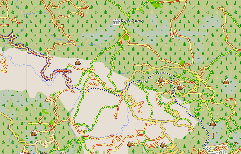
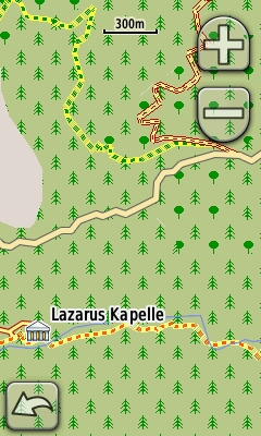
The Map of was created and developed by a friend "Nikolakis the Great", who has spent and offers much of his free time. His aim is to create a map for travelers in Greece, containing details of Archaeological sites, Trails, Beaches, Forests, National Parks etc. items that do not exist in commercial maps. Those of you want, you can freely participate in the enrichment of the map sending more data from the areas you know best and see that something is missing.
[color="#FF0000"]CAUTION..... RECOMMENDED to put the maps on the card AND NOT IN THE MEMORY OF THE DEVICE. SO IF ANY PROBLEM presented REMOVE THE CARD AND DEVICE keeps working properly.[/color]
For any bug report, suggestion or impairment send e-mail to the address [email="[email protected]"][email protected][/email]
[Please Register or Login to download file] How to create a map for Garmin devices in GREEK lang ONLY.
[Please Register or Login to download file] details of the Symbols of the MAP in GREEK Lang ONLY
Compatible devices (confirmed):
Nüvi 1200
Nüvi 205/205w 200/200w
Nüvi 760
Oregon x50
Problems:
MapSource-BaseCamp can not route between three or more tiles.
Background device is defective at Nüvi 37xx. All other functions work correctly.
Background device is partially defective at Nüvi 34xx/ All other functions work correctly.
MobileXT can not route between tiles.
NEW SITES
Mobile PC

3760
MAPSOURCE
[color="#FF0000"]CAUTION RECOMMENDED to put the maps on the card AND NOT IN MEMORY OF THE DEVICE. SO IF ANY PROBLEM presented REMOVE THE CARD AND DEVICE keeps working properly.[/color]
[color="#0000CD"]NEW VERSION UPDATED 2012.01.23[/color]
This map is based on data from [Please Register or Login to download file] and is licensed under the [Please Register or Login to download file] , and contains data from [Please Register or Login to download file] .
ROUTABLE BUT NOT CONTAIN ALL THE ONEWAY STREET DATA
This map is offered in two software/device forms:
For GARMIN software or devices.
Για Navitel software. CAUTION: To work properly the map needs to use Navitel with version 3.2 to 3.5, because newer versions have trouble to open map in nm2 format. This map is exported with GPSMapEdit which can export maps only in this format.
NOTE: multilanguage support is not completed and depends at the data of the map.
[color="#FF0000"]For use directly to your device. You can copy directly to the EXTERNAL memory of your device (important: not directly to the device). If your device is old and does not "see" the map rename the file to "gmapsupp.img" (attention Do NOT OVERWRITE AND not delete your own maps and weep! Will not be my fault.).[/color]
Map for GARMIN
You’ll find it in two versions:
For use directly from your device. You can copy it directly to the memory card of your device (important: not directly to the device). If your device is old and does not “see” the map, rename the file to “gmapsupp.img” (Attention: do not override or delete your own maps (if there is any with this name!.).
Installation for MapSource / BaseCamp. This is an installation file of the map in MapSource. After installation you can uninstall the map through Add or Remove Programs on Windows Control Panel applet.
Current version 2012.01.23:
There are a lot of user updates at every version of this map, but is very difficult to record. Basic or big changes will be presented here.
New in Version 2012.01.23
Archeaoligical sites:
Acropolis of Athens, Ancient Agora of Athens, Zeus Temple.
Delphi
Ancient Olympia
Mycenea
Ancient Korinth, Akrokorinth
Amfiaraion
Contours: per 20 meters (65.6 feet), improve, without holes. Smaller file by removing tiles outside Greece. This verion is only for GARMIN. There is another file for Navitel provided by giannis_05. A big THANKS to my friend giannis_05 for his help and his offer to this version.
[Please Register or Login to download file]
[Please Register or Login to download file]
PREVIOUS Version 2012.01.09:
What’s new:
Contours. This is a separate file, because of its size. Thre are contours every 25 meters (82 feet). At some areas of the map the data are not completed so there are some “holes” there.
Map legend (if you install the map for MapSource/BaseCamp) at the start menu of Windows
There is also a map that contains (only) contours every 25 meters (82 feet). This is a separate file because of its size, and it's available for GARMIN and Navitel.
If you install the map to your PC for MapSource/BaseCamp you'll find a shortcut named "Map Legend" at the folder "Nikos Skouteris" under the Windows start menu, that opens a HTML page containing information about the map elements.
[color="#0000FF"]Current version is 2012.01.23[/color]
[Please Register or Login to download file]
[color="#0000CD"][Please Register or Login to download file] [/color]
GARMIN DEVICE
[Please Register or Login to download file]
[Please Register or Login to download file]
[Please Register or Login to download file]
[Please Register or Login to download file]
MapSource/BaseCamp:
[Please Register or Login to download file]
[Please Register or Login to download file]
[Please Register or Login to download file]
[Please Register or Login to download file]
[Please Register or Login to download file]
Or Here [Please Register or Login to download file]
PREVIOUS version 2011.12.25:
Soon will uploaded the English Version of AutoDrive
Map for Navitel
Current Version 2012.01.23
[Please Register or Login to download file]
[Please Register or Login to download file]
[Please Register or Login to download file]
[Please Register or Login to download file]
[Please Register or Login to download file]
or HERE>>> [Please Register or Login to download file]
CONTOURS FROM giannis_05 [Please Register or Login to download file]
[Please Register or Login to download file]
Pevious version 2011.12.25:
[Please Register or Login to download file]
[Please Register or Login to download file]
The Map of was created and developed by a friend "Nikolakis the Great", who has spent and offers much of his free time. His aim is to create a map for travelers in Greece, containing details of Archaeological sites, Trails, Beaches, Forests, National Parks etc. items that do not exist in commercial maps. Those of you want, you can freely participate in the enrichment of the map sending more data from the areas you know best and see that something is missing.
[color="#FF0000"]CAUTION..... RECOMMENDED to put the maps on the card AND NOT IN THE MEMORY OF THE DEVICE. SO IF ANY PROBLEM presented REMOVE THE CARD AND DEVICE keeps working properly.[/color]
For any bug report, suggestion or impairment send e-mail to the address [email="[email protected]"][email protected][/email]
[Please Register or Login to download file] How to create a map for Garmin devices in GREEK lang ONLY.
[Please Register or Login to download file] details of the Symbols of the MAP in GREEK Lang ONLY
Compatible devices (confirmed):
Nüvi 1200
Nüvi 205/205w 200/200w
Nüvi 760
Oregon x50
Problems:
MapSource-BaseCamp can not route between three or more tiles.
Background device is defective at Nüvi 37xx. All other functions work correctly.
Background device is partially defective at Nüvi 34xx/ All other functions work correctly.
MobileXT can not route between tiles.
NEW SITES
Mobile PC
3760
MAPSOURCE
[color="#FF0000"]CAUTION RECOMMENDED to put the maps on the card AND NOT IN MEMORY OF THE DEVICE. SO IF ANY PROBLEM presented REMOVE THE CARD AND DEVICE keeps working properly.[/color]
Tue Jan 10, 2012 2:11 pm
Tue Jan 10, 2012 2:19 pm
EDIT MOVED TO 1st POST.
but disappeared.
THE MAP IS FREE FOR GARMIN AND NAVITEL
This map is based on data from [Please Register or Login to download file] and is licensed under the [Please Register or Login to download file] , and contains data from [Please Register or Login to download file] .
ROUTABLE BUT NOT CONTAIN ALL THE ONE WAY STREET DATA
This map is offered in two software/device forms:
For GARMIN software or devices.
Για Navitel software. CAUTION: To work properly the map needs to use Navitel with version 3.2 to 3.5, because newer versions have trouble to open map in nm2 format. This map is exported with GPSMapEdit which can export maps only in this format.
NOTE: multilanguage support is not completed and depends at the data of the map.
[Please Register or Login to download file]
[color="#FF0000"]For use directly to your device. You can copy directly to the EXTERNAL memory of your device (important: not directly to the device). If your device is old and does not "see" the map rename the file to "gmapsupp.img" (attention Do NOT OVERWRITE AND not delete your own maps and weep! Will not be my fault.).
[/color]
Map for GARMIN
You’ll find it in two versions:
For use directly from your device. You can copy it directly to the memory card of your device (important: not directly to the device). If your device is old and does not “see” the map, rename the file to “gmapsupp.img” (Attention: do not override or delete your own maps (if there is any with this name!.).
Installation for MapSource / BaseCamp. This is an installation file of the map in MapSource. After installation you can uninstall the map through Add or Remove Programs on Windows Control Panel applet.
Current Version 2012.01.09:
What’s new:
Contours. This is a separate file, because of its size. Thre are contours every 25 meters (82 feet). At some areas of the map the data are not completed so there are some “holes” there.
Map legend (if you install the map for MapSource/BaseCamp) at the start menu of Windows
There is also a map that contains (only) contours every 25 meters (82 feet). This is a separate file because of its size, and it's available for GARMIN and Navitel.
If you install the map to your PC for MapSource/BaseCamp you'll find a shortcut named "Map Legend" at the folder "Nikos Skouteris" under the Windows start menu, that opens a HTML page containing information about the map elements.
[Please Register or Login to download file]
Συσκευή:
[Please Register or Login to download file]
[Please Register or Login to download file]
[Please Register or Login to download file]
[Please Register or Login to download file]
MapSource/BaseCamp:
[Please Register or Login to download file]
[Please Register or Login to download file]
[Please Register or Login to download file]
[Please Register or Login to download file]
[Please Register or Login to download file]
Or Here [Please Register or Login to download file]
Previous version 2011.12.25:
Device:
[Please Register or Login to download file]
[Please Register or Login to download file]
MapSource/BaseCamp:
[Please Register or Login to download file]
[Please Register or Login to download file]
And here the MAP with the [Please Register or Login to download file] greek Unlocked
Soon will upload the English Version of AutoDrive
Map for Navitel
Current Version 2012.01.09
[Please Register or Login to download file]
[Please Register or Login to download file]
[Please Register or Login to download file]
[Please Register or Login to download file]
[Please Register or Login to download file]
or HERE>>> [Please Register or Login to download file]
Previous version 2011.12.25:
[Please Register or Login to download file]
[Please Register or Login to download file]
The Map of was created and developed by a friend "Nikolakis the Great", who has spent and offers much of his free time. His aim is to create a map for travelers in Greece, containing details of Archaeological sites, Trails, Beaches, Forests, National Parks etc. items that do not exist in commercial maps. Those of you want, you can freely participate in the enrichment of the map sending more data from the areas you know best and see that something is missing.
[color="#FF0000"]CAUTION..... RECOMMENDED to put the maps on the card AND NOT IN THE MEMORY OF THE DEVICE. SO IF ANY PROBLEM presented REMOVE THE CARD AND DEVICE keeps working properly.[/color]
For any bug report, suggestion or impairment send e-mail to the address [email="[email protected]"][email protected][/email]
[Please Register or Login to download file] How to create a map for Garmin devices in GREEK lang ONLY.
[Please Register or Login to download file] details of the Symbols of the MAP in GREEK Lang ONLY
Compatible devices (confirmed):
Nüvi 1200
Nüvi 205/205w 200/200w
Nüvi 760
Oregon x50
Problems:
MapSource-BaseCamp can not route between three or more tiles.
Background device is defective at Nüvi 37xx. All other functions work correctly.
Background device is partially defective at Nüvi 34xx/ All other functions work correctly.
MobileXT can not route between tiles.
OREGON 450
Mobile PC
3760
MAPSOURCE
[color="#FF0000"]CAUTION RECOMMENDED to put the maps on the card AND NOT IN MEMORY OF THE DEVICE. SO IF ANY PROBLEM presented REMOVE THE CARD AND DEVICE keeps working properly.[/color]
Tue Jan 10, 2012 3:45 pm
Ok, but where are the links?
Tue Jan 10, 2012 4:06 pm
not so easy to find, if you can't read greek, but possible:
3683
3683
Tue Jan 10, 2012 4:17 pm
Now it´s all here. I´m too fast 
@Pixeldealer
Gibt es ja auch in Englisch, "Kapelle" klingt sogar sehr deutsch
@Pixeldealer
Gibt es ja auch in Englisch, "Kapelle" klingt sogar sehr deutsch
Tue Jan 10, 2012 4:20 pm
Hopefully the Links are Up again. Sorry about the inconvenience.
THE MAP IS FREE FOR GARMIN AND NAVITEL
This map is based on data from [Please Register or Login to download file] and is licensed under the [Please Register or Login to download file] , and contains data from [Please Register or Login to download file] .
ROUTABLE BUT NOT CONTAIN ALL THE ONE WAY STREET DATA
This map is offered in two software/device forms:
For GARMIN software or devices.
Για Navitel software. CAUTION: To work properly the map needs to use Navitel with version 3.2 to 3.5, because newer versions have trouble to open map in nm2 format. This map is exported with GPSMapEdit which can export maps only in this format.
NOTE: multilanguage support is not completed and depends at the data of the map.
[Please Register or Login to download file]
[color="#FF0000"]For use directly to your device. You can copy directly to the EXTERNAL memory of your device (important: not directly to the device). If your device is old and does not "see" the map rename the file to "gmapsupp.img" (attention Do NOT OVERWRITE AND not delete your own maps and weep! Will not be my fault.).
[/color]
Map for GARMIN
You’ll find it in two versions:
For use directly from your device. You can copy it directly to the memory card of your device (important: not directly to the device). If your device is old and does not “see” the map, rename the file to “gmapsupp.img” (Attention: do not override or delete your own maps (if there is any with this name!.).
Installation for MapSource / BaseCamp. This is an installation file of the map in MapSource. After installation you can uninstall the map through Add or Remove Programs on Windows Control Panel applet.
Current Version 2012.01.09:
What’s new:
Contours. This is a separate file, because of its size. Thre are contours every 25 meters (82 feet). At some areas of the map the data are not completed so there are some “holes” there.
Map legend (if you install the map for MapSource/BaseCamp) at the start menu of Windows
There is also a map that contains (only) contours every 25 meters (82 feet). This is a separate file because of its size, and it's available for GARMIN and Navitel.
If you install the map to your PC for MapSource/BaseCamp you'll find a shortcut named "Map Legend" at the folder "Nikos Skouteris" under the Windows start menu, that opens a HTML page containing information about the map elements.
[Please Register or Login to download file]
Συσκευή:
[Please Register or Login to download file]
[Please Register or Login to download file]
[Please Register or Login to download file]
[Please Register or Login to download file]
MapSource/BaseCamp:
[Please Register or Login to download file]
[Please Register or Login to download file]
[Please Register or Login to download file]
[Please Register or Login to download file]
[Please Register or Login to download file]
Or Here [Please Register or Login to download file]
Previous version 2011.12.25:
Device:
[Please Register or Login to download file]
[Please Register or Login to download file]
MapSource/BaseCamp:
[Please Register or Login to download file]
[Please Register or Login to download file]
And here the MAP with the [Please Register or Login to download file] greek Unlocked
Soon will upload the English Version of AutoDrive
Map for Navitel
Current Version 2012.01.09
[Please Register or Login to download file]
[Please Register or Login to download file]
[Please Register or Login to download file]
[Please Register or Login to download file]
[Please Register or Login to download file]
or HERE>>> [Please Register or Login to download file]
Previous version 2011.12.25:
[Please Register or Login to download file]
[Please Register or Login to download file]
The Map of was created and developed by a friend "Nikolakis the Great", who has spent and offers much of his free time. His aim is to create a map for travelers in Greece, containing details of Archaeological sites, Trails, Beaches, Forests, National Parks etc. items that do not exist in commercial maps. Those of you want, you can freely participate in the enrichment of the map sending more data from the areas you know best and see that something is missing.
[color="#FF0000"]CAUTION..... RECOMMENDED to put the maps on the card AND NOT IN THE MEMORY OF THE DEVICE. SO IF ANY PROBLEM presented REMOVE THE CARD AND DEVICE keeps working properly.[/color]
For any bug report, suggestion or impairment send e-mail to the address [email="[email protected]"][email protected][/email]
[Please Register or Login to download file] How to create a map for Garmin devices in GREEK lang ONLY.
[Please Register or Login to download file] details of the Symbols of the MAP in GREEK Lang ONLY
Compatible devices (confirmed):
Nüvi 1200
Nüvi 205/205w 200/200w
Nüvi 760
Oregon x50
Problems:
MapSource-BaseCamp can not route between three or more tiles.
Background device is defective at Nüvi 37xx. All other functions work correctly.
Background device is partially defective at Nüvi 34xx/ All other functions work correctly.
MobileXT can not route between tiles.
OREGON 450
Mobile PC
3760
MAPSOURCE
[color="#FF0000"]CAUTION RECOMMENDED to put the maps on the card AND NOT IN MEMORY OF THE DEVICE. SO IF ANY PROBLEM presented REMOVE THE CARD AND DEVICE keeps working properly.[/color]
Tue Jan 10, 2012 4:34 pm
:D...many misunderstandings, but I hope now all pleased...:D
Thu Mar 01, 2012 7:03 pm
new version 2012.02.19
link
link
- Code:
[url=http://skouteris.wordpress.com/gps/greecemap_en/]Map of Greece «[/url]