Garmin German and Austrian Alps - Alpenvereinskarten
Sat Jul 09, 2011 9:08 pm
[SIZE="5"][color="darkgreen"]Garmin Alpenvereinskarten[/color]
maps created by German and Austrian Alpine Clubs[/size]
[Please Register or Login to download file]
* Image with AV raster maps: *
- GMAPPROM.IMG
- FID 2424 PID 1
- unlocked
- 343 tiles
- size 3.25 GB
* Image with AV map labeling: *
- GMAPSUPP.IMG
- FID 2424 PID 1
- unlocked
- 4 tiles
- size 795 kB
* POI file: *
- Alpenvereins-POIs.gpi
- FID 4647 PID 2
- locked
- size 9.45 MB
* draw priority 30 *
[color="red"]* this map can only be used with compatible devices, that can show raster maps *[/color]
(e.g. Oregon, Dakota, Montana, GPSmap62/78)
[color="red"]* this map can be used on PC/Mac with BaseCamp, but not with MapSource! *[/color]
[SPOILER="Download"][Please Register or Login to download file]
[Please Register or Login to download file]
Mirror:
[Please Register or Login to download file]
[Please Register or Login to download file]
single links, click'n'load and container formats
Download with JDownloader or CryptLoad recommended.
RAR-PW: p!xeldealer[/spoiler]
All credits to [color="blue"]hurb1[/color]
maps created by German and Austrian Alpine Clubs[/size]
[Please Register or Login to download file]
* Header-Date: 2011-03-16 *Features
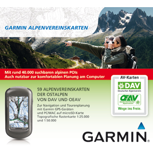
- Get ready to mountaineer the Northeastern Alps with these high-quality raster maps created by German and Austrian Alpine Clubs.
- This map set features 40,000 searchable alpine points of interest, including shelters, villages and mountain tops.
- Features an overview map for fast and convenient orientation as well as 59 alpine club raster maps, optimized for compatible devices.
- Includes an alpine club mountain shelter directory with lots of helpful information, including pictures, phone numbers and altitude.
- Offers more than 2,000 back country skiing tours, throughout Germany and Austria, with a regional sorted list of starting and ending points.
- Provides extra labeling of the most important alpine points of interest for the perfect overview. The labels can be switched on and off, according to users preferences (compatible devices only).
* Image with AV raster maps: *
- GMAPPROM.IMG
- FID 2424 PID 1
- unlocked
- 343 tiles
- size 3.25 GB
* Image with AV map labeling: *
- GMAPSUPP.IMG
- FID 2424 PID 1
- unlocked
- 4 tiles
- size 795 kB
* POI file: *
- Alpenvereins-POIs.gpi
- FID 4647 PID 2
- locked
- size 9.45 MB
* draw priority 30 *
[color="red"]* this map can only be used with compatible devices, that can show raster maps *[/color]
(e.g. Oregon, Dakota, Montana, GPSmap62/78)
[color="red"]* this map can be used on PC/Mac with BaseCamp, but not with MapSource! *[/color]
[SPOILER="Download"][Please Register or Login to download file]
[Please Register or Login to download file]
Mirror:
[Please Register or Login to download file]
[Please Register or Login to download file]
single links, click'n'load and container formats
Download with JDownloader or CryptLoad recommended.
RAR-PW: p!xeldealer[/spoiler]
All credits to [color="blue"]hurb1[/color]
Fri Aug 12, 2011 12:57 pm
Beautiful maps..thanks
How can one see the ski-routes and other POI info using Basecamp?
I can see huts and ski-routes using the POI drop-down in Basecamp,, but don't see the detailed skiroutes on the map, nor any photos that are advertised.
Any help would be appreciated
How can one see the ski-routes and other POI info using Basecamp?
I can see huts and ski-routes using the POI drop-down in Basecamp,, but don't see the detailed skiroutes on the map, nor any photos that are advertised.
Any help would be appreciated
Wed Nov 23, 2011 2:36 pm
mirror
- Code:
copy this link

http://search.data.bg/ready/a7fbafaa46cde428b39552b57b718bac

and

http://search.data.bg/ready/781dfbf1bf005890cbe213c0537b769c

here

[url]http://bgtorrentz.net/[/url]

click open

then click : Свали файла (Save File)
this is not a torrent
Thu Dec 13, 2012 12:03 pm
Thank you for the map. Do you happen to have the new version also?
Fri Dec 14, 2012 1:01 pm
You can be sure, it will be posted here, as it is available anywhere.