
 Forum
Forum
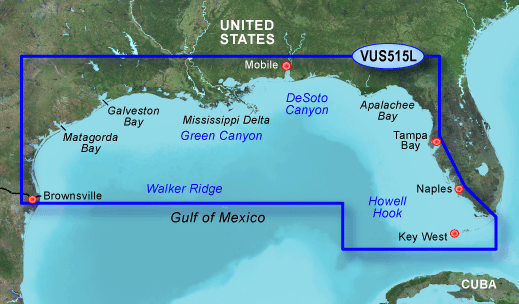
The Garmin Bluechart g2 Vision VUS515L navigation software contains information of Brownsville to Key Largo with detailed coverage of Gulf of Mexico from Brownsville to Plantation Key including Matagorda Bay, Galveston Bay, Mississippi Delta, Tampa Bay and the Florida Keys. The card also provides bathymetric coverage of offshore features from Northwest Slope to Tortugas Terrace including Green Canyon, DeSoto Canyon, Howell Hook, and Tortugas Bank. With BlueChart g2 Vision card, you'll have access to detailed mapping capabilities which include standardized depth contours, smooth data transition between zoom levels, harmonious transition across chart borders, and reduction of chart discontinuities.
The Bluechart g2 vision VUS515L offers most realistic mapping display Garmin has ever offered. It includes premium features, such as true 3D-view perspective above and below the waterline, auto guidance, high-resolution imagery, and aerial reference photography providing "real picture" aerial photos of ports, harbors, marinas, waterways, navigation landmarks and other points of interest.
Bluechart g2 Vision VUS515L Features:
- Brownsville - Key Largo Digital Map
- Covers Gulf of Mexico from Brownsville to Plantation Key, Galveston Bay, Mississippi Delta, Tampa Bay & the Florida Keys
- High-Resolution Satellite Imagery
- Standardized Depth Contours
- Aerial Reference Photography
- "Real World" Photos of Ports / Harbors / Marinas / Waterways / Navigation Landmarks / Points of Interest - Smooth Data Transition Between Zoom Levels
- Auto Guidance Technology
- Includes Tides / Currents / Marine Services / Coastal Roads / Points of Interest - Mariner's Eye View
- Fish Eye View
- - 3D-View Above & Below Waterline
- Harmonious Chart Borders Transition
- Reduced Chart Discontinuities
MapID=2024
[SIZE="3"][Please Register or Login to download file]
[Please Register or Login to download file]
[Please Register or Login to download file] [/size]
[SIZE="1"][Please Register or Login to download file]
[Please Register or Login to download file]
MapID=488[/size]
[Please Register or Login to download file]
Thanks to Goggleye


