cityXplorer Paris 2012.30   

cityXplorer Paris 2012.30

Postby bam-bam » Thu Dec 08, 2011 4:33 pm

Image

City Public Transportation

Bus
Metro Railway
Railroad
Tram

Other Features

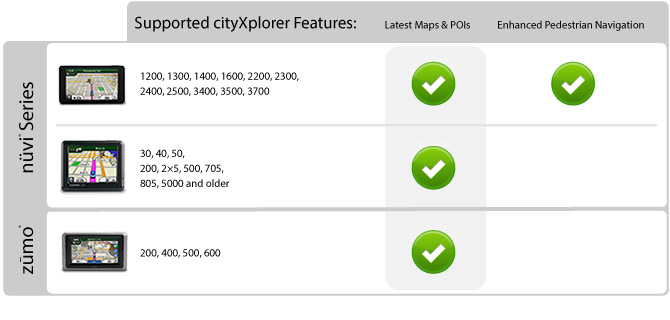
Includes the same detailed street data and information found in City Navigator® maps; powered by NAVTEQ.
Displays the latest roads and points of interest, including hotels, restaurants, parking, entertainment, fuel, shopping and more.
Gives turn-by-turn directions on your compatible device.
Includes detailed route information, including turn restrictions, roundabout guidance, speed limits and Lane Assist (on compatible devices), and other navigational features.
Features enhanced pedestrian navigation, which makes it easy to get around town via public transportation - walking, train, tram, bus, subway, taxi or a combination of options - on compatible devices¹ (Not all forms of public transportation are available on all cityXplorer products)

¹Adding cityXplorer maps to a unit that does not support enhanced pedestrian navigation ONLY will allow for viewing of cityXplorer maps and points of interest and is not recommended if the city already is preloaded to your device. Only 1 region can be downloaded directly to devices that do not support pedestrian navigation. Additional regions can be downloaded to individual data cards.
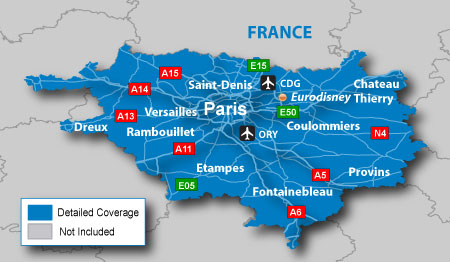

Image

About Coverage

Includes detailed road maps and points of interest for the city of Paris, France, with the ability to navigate using buses, tramway, metro and suburban rail systems (where available. Not all cities include all public transit types).

Features detailed coverage for the greater Paris metro area, including Aéroport de Paris Charles de Gaulle (CDG) airport, and the départements 75, 93, 92 and 94, plus portions of departments 77, 78, 91 and 95.

The city of Versailles and Disneyland Paris both are included.

*Coverage area map shows major roads, highways and points of interest only. Enhanced pedestrian navigation coverage varies within the area shown.


Image


Locked IMG. MapID/FID=2492, PID=2, RgnID=1, VenID=21
This map has MMR data for Enhanced Pedestrian Mode. The EPM mode is only used in newer Garmin units and mostly the ones in the premium range.
Other Garmin units without EPM sees this map as an ordinary City Navigator NT map.


cityXplorer Paris 2012.30.rar (19.75 MB)
Code: Select all
[url]https://hotfile.com/dl/137026612/41f70d9/cityXplorer_Paris_2012.30.rar.html[/url]


Locked IMG with 3D buildings for compatible units. MapID/FID=2492, PID=2, RgnID=1, VenID=21

cityXplorer Paris 2012.30_30_3d.rar (9.97 MB)
Code: Select all
[url]http://hotfile.com/dl/137026519/bbb98e5/cityXplorer_Paris_2012.30_30_3d.rar.html[/url]
bam-bam offline


User avatar Ex Moderator


Joined: Fri Jul 23, 2010 9:43 pm
Posts: 1420
Location: .BG
Has thanked: 51 times
Been thanked: 2004 times
Age: 44

Postby dutchbird » Fri Feb 17, 2012 3:35 pm

Multiupload doesn't work anymore
dutchbird offline


Junior Member


Joined: Sun Feb 05, 2012 3:22 pm
Posts: 13
Has thanked: 0 time
Been thanked: 0 time

Postby LonelyPixel » Tue Jun 26, 2012 4:38 pm

The map doesn't authenticate, either with custom map parameters or only with the map ID. Using a Dakota 20.
LonelyPixel offline


Junior Member


Joined: Sat Apr 09, 2011 12:21 pm
Posts: 3
Has thanked: 0 time
Been thanked: 0 time

Postby ph_paulissen » Tue Sep 25, 2012 3:13 pm

Hi,

I downloaded the map and installed it on my eTrex30.
At starting, the device says : " Cannot unlock Maps "

please could you tell me what to do. :(
I'm working on Mac, but have the possibility to run a PC as well.

thanks

P
ph_paulissen offline


Junior Member


Joined: Mon Jun 18, 2012 10:30 am
Posts: 40
Has thanked: 13 times
Been thanked: 1 time
Age: 66

Postby p!xeldealer » Tue Sep 25, 2012 5:29 pm

On eTrex and all other outdoor devices you'd better use City Navigator, because only nuvi 1xxx, 2xxx and 3xxx have enhanced pedestrian mode for cityXplorer maps.
~~~~~~~~~~~~~~~~~~~~~~~~~~~~~~~~~~~~~~~~~~~~~~~~~~~~~
The presentation of this posting exists of 100% of recycleable, taste-neutral, not genetic-
manipulated and unleaded pixels free of CFC - this guarantees for You p!xeldealer :yahoo:
p!xeldealer offline


User avatar Ex Moderator


Joined: Wed Dec 30, 2009 3:36 pm
Posts: 704
Has thanked: 352 times
Been thanked: 46 times

Postby bam-bam » Tue Sep 25, 2012 5:35 pm

i think this help

Code: Select all
How to unlock an original CX map
You must create the .unl file with PID 2 and the FID of the related City Navigator-
Enable additional fields in Jetmouse keygen and insert PID 2 and the right FID-
Copy the anyname.img (eg. Paris.img) and anyname.unl (eg. Paris.unl) in "Map" folder in your sd
bam-bam offline


User avatar Ex Moderator


Joined: Fri Jul 23, 2010 9:43 pm
Posts: 1420
Location: .BG
Has thanked: 51 times
Been thanked: 2004 times
Age: 44

Postby ph_paulissen » Tue Sep 25, 2012 5:43 pm

thanks for this advice...:think:
ph_paulissen offline


Junior Member


Joined: Mon Jun 18, 2012 10:30 am
Posts: 40
Has thanked: 13 times
Been thanked: 1 time
Age: 66


Return to New Maps


  • Related topics
    Replies
    Views
    Last post

Who is online

Users browsing this forum: Boehari, rocksinhead and 8 guests