
 Forum
Forum
Navigate the big city like your hometown with cityXplorer Milan for your street navigator. This detailed city map provides the latest roads and points of interest for the metropolitan area, plus enhanced pedestrian navigation¹ — street directions that let you use public transportation to get you where you need to go.
Get the Map Data You Need
cityXplorer Milan includes the same detailed street data and information found in City Navigator® maps. This convenient download puts the latest street maps and most up-to-date points of interest on your device, so you'll have updated local information for shopping, restaurants, hotels, entertainment, parking and so much more. Click the View Map tab for detailed coverage information.
Navigate Public Transit¹
On compatible devices, this city map makes it easy to get around town with enhanced pedestrian navigation¹. While navigating a route, select Pedestrian mode on your Garmin device and then choose which forms of public transportation you'd like to use: walking, train, tram, bus, subway, taxi or a combination of options (where available)². Your device tells you where to walk, where to catch the bus or other transportation and how long it will take to get there. In some cities, data even may be available for transit schedules, such as subway or bus times and routes.
¹Enhanced pedestrian mode, which includes public transit information, is available on compatible devices only. Adding cityXplorer maps to a unit that does not support pedestrian navigation ONLY will allow for viewing of cityXplorer maps and points of interest and is not recommended if the city already is preloaded to your device. Only 1 region can be downloaded directly to devices that do not support pedestrian navigation. Additional regions can be downloaded to individual data cards.
²Not all forms of public transportation are available on all cityXplorer products.
- Includes the same detailed street data and information found in City Navigator® maps, the most detailed content available. Powered by NAVTEQ, a world leader in premium-quality digital map data.
- Displays the latest points of interest, including hotels, restaurants, parking, entertainment, fuel, shopping and more.
- Gives turn-by-turn directions on your compatible Garmin device.
- Includes detailed information, such as turn restrictions, roundabout guidance, speed limits (compatible devices only) and other navigation features.
- Provides enhanced pedestrian mode — street directions that use any available forms of public transportation: bus, subway, metrorail, tramway, taxi and more (compatible devices only).
- Provides Lane Assist for compatible devices.
Includes detailed road maps and points of interest for the City of Milan, Italy, with the ability to navigate using buses, tramway, metro and suburban rail systems where available. Not all cities include all public transit types¹.
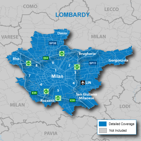
Features detailed coverage for the greater Milan metro area, including Aeroporto di Linate (LIN), and the 9 administrative zones of Milan.
- Coverage area map shows major roads, highways and points of interest coverage only. Enhanced pedestrian navigation coverage varies within the area shown.
PID: 2, FID: 2204
[SIZE="3"][Please Register or Login to download file] [/size]
Pass: [color="sienna"]huntsman[/color]
[Please Register or Login to download file]
[SIZE="2"]Thanks Catymag[/size]


