Forum
Forum
Credits to [color="sienna"]catymag[/color]
- Includes the same detailed street data and information found in City Navigator® maps, the most detailed content available. Powered by NAVTEQ, a world leader in premium-quality digital map data.
- Displays the latest points of interest, including hotels, restaurants, parking, entertainment, fuel, shopping and more.
- Gives turn-by-turn directions on your compatible Garmin device.
- Includes detailed information, such as turn restrictions, roundabout guidance, speed limits (compatible devices only) and other navigation features.
- Provides enhanced pedestrian mode — street directions that use any available forms of public transportation: bus, subway, metrorail, tramway, taxi and more (compatible devices only).
- Provides Lane Assist for compatible devices.
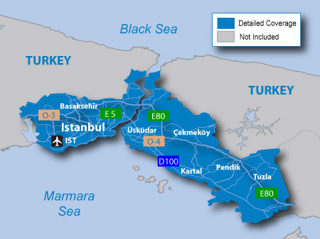
About Coverage
Includes detailed road maps and points of interest for the City of Istanbul, Turkey, with the ability to navigate using buses, tramway, metro and suburban rail systems where available. Not all cities include all public transit types¹.
Features detailed coverage for the greater Istanbul metro area, including Atatürk (IST) and Sabiha Gökçen (SAW) international airports, and all of the districts of:
- Bağcılar
- Bahçelievler
- Bakırköy
- Bayrampaşa
- Beşiktaş
- Beyoğlu
- Eminönü
- Fatih
- Güngören
- Kadıköy
- Kağıthane
- Maltepe
- Şişli
- Sultanbeyli
- Tuzla
- Zeytinburnu
- Üsküdar
Partial coverage is provided for the districts of: Beykoz, Esenler, Eyüp, Gaziosmanpaşa, Gebze, Kartal, Küçükçekmece, Pendik and Sarıyer.
*Coverage area map shows major roads, highways and points of interest coverage only. Enhanced pedestrian navigation coverage varies within the area shown.
to enable Ped. and Public Trans. feature
PID 2, FID 2419, region 1,39 (Nuvi 37xx series excluded)
[SIZE="3"][Please Register or Login to download file] [/size](11,3 MB)