CityXplorer - Amsterdam 2010.20
Sat Dec 04, 2010 8:52 pm
[SIZE="4"]CityXplorer - Amsterdam 2010.20[/size]
Navigate the big city like your hometown with cityXplorer Amsterdam for your street navigator. This detailed city map provides the latest roads and points of interest for the metropolitan area, plus enhanced pedestrian navigation¹ — street directions that let you use public transportation to get you where you need to go.
Get the Map Data You Need
cityXplorer Amsterdam includes the same detailed street data and information found in City Navigator® maps. This convenient download puts the latest street maps and most up-to-date points of interest on your device, so you'll have updated local information for shopping, restaurants, hotels, entertainment, parking and so much more. Click the View Map tab for detailed coverage information.
Navigate Public Transit¹
On compatible devices, this city map makes it easy to get around town with enhanced pedestrian navigation¹. While navigating a route, select Pedestrian mode on your Garmin device and then choose which forms of public transportation you'd like to use: walking, train, tram, bus, subway, taxi or a combination of options (where available)². Your device tells you where to walk, where to catch the bus or other transportation and how long it will take to get there. In some cities, data even may be available for transit schedules, such as subway or bus times and routes.
¹Enhanced pedestrian mode, which includes public transit information, is available on compatible devices only. Adding cityXplorer maps to a unit that does not support pedestrian navigation ONLY will allow for viewing of cityXplorer maps and points of interest and is not recommended if the city already is preloaded to your device. Only one region can be downloaded directly to devices that do not support pedestrian navigation. Additional regions can be downloaded to individual data cards.
²Not all forms of public transportation are available on all cityXplorer products.
Includes detailed road maps and points of interest for the City of Amsterdam, North Holland, the Netherlands, with the ability to navigate using buses, tramway, metro and suburban rail systems where available. Not all cities include all public transit types.¹
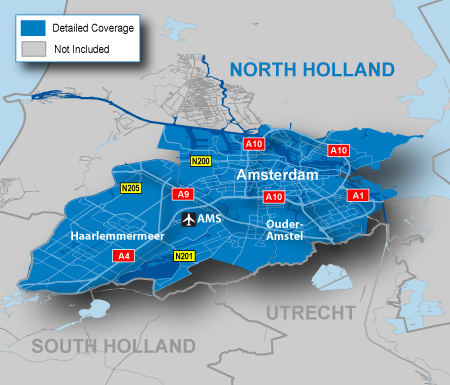
Features detailed coverage of the Amsterdam, Netherlands area, including Luchthaven Schiphol Airport (AMS), and the boroughs of Noord and Westpoort to the north; Zeeburg and Zuidoost to the east; Zuideramstel, Oud-Zuid and Slotervaart to the south; and Osdorp and Geuzenveld to the west.
Coverage extends to surrounding cities, including Haarlemmermeer, Nieuw-Vennep, Ouder-Amstel and Aalsmeer.
¹Not all forms of public transportation are available on all cityXplorer products.
PID 2, FID 2004, region 1,1
[SIZE="3"][Please Register or Login to download file] [/size]
Pass: [color="sienna"]huntsman[/color]
[Please Register or Login to download file]
[SIZE="2"]Thanks Catymag[/size]
Navigate the big city like your hometown with cityXplorer Amsterdam for your street navigator. This detailed city map provides the latest roads and points of interest for the metropolitan area, plus enhanced pedestrian navigation¹ — street directions that let you use public transportation to get you where you need to go.
Get the Map Data You Need
cityXplorer Amsterdam includes the same detailed street data and information found in City Navigator® maps. This convenient download puts the latest street maps and most up-to-date points of interest on your device, so you'll have updated local information for shopping, restaurants, hotels, entertainment, parking and so much more. Click the View Map tab for detailed coverage information.
Navigate Public Transit¹
On compatible devices, this city map makes it easy to get around town with enhanced pedestrian navigation¹. While navigating a route, select Pedestrian mode on your Garmin device and then choose which forms of public transportation you'd like to use: walking, train, tram, bus, subway, taxi or a combination of options (where available)². Your device tells you where to walk, where to catch the bus or other transportation and how long it will take to get there. In some cities, data even may be available for transit schedules, such as subway or bus times and routes.
¹Enhanced pedestrian mode, which includes public transit information, is available on compatible devices only. Adding cityXplorer maps to a unit that does not support pedestrian navigation ONLY will allow for viewing of cityXplorer maps and points of interest and is not recommended if the city already is preloaded to your device. Only one region can be downloaded directly to devices that do not support pedestrian navigation. Additional regions can be downloaded to individual data cards.
²Not all forms of public transportation are available on all cityXplorer products.
- Includes the same detailed street data and information found in City Navigator® maps, the most detailed content available. Powered by NAVTEQ, a world leader in premium-quality digital map data.
- Displays the latest points of interest, including hotels, restaurants, parking, entertainment, fuel, shopping and more.
- Gives turn-by-turn directions on your compatible Garmin device.
- Includes detailed information, such as turn restrictions, roundabout guidance, speed limits (compatible devices only) and other navigation features.
- Provides enhanced pedestrian mode — street directions that use any available forms of public transportation: bus, subway, metrorail, tramway, taxi and more (compatible devices only).
- Provides Lane Assist for compatible devices.
Includes detailed road maps and points of interest for the City of Amsterdam, North Holland, the Netherlands, with the ability to navigate using buses, tramway, metro and suburban rail systems where available. Not all cities include all public transit types.¹
Features detailed coverage of the Amsterdam, Netherlands area, including Luchthaven Schiphol Airport (AMS), and the boroughs of Noord and Westpoort to the north; Zeeburg and Zuidoost to the east; Zuideramstel, Oud-Zuid and Slotervaart to the south; and Osdorp and Geuzenveld to the west.
Coverage extends to surrounding cities, including Haarlemmermeer, Nieuw-Vennep, Ouder-Amstel and Aalsmeer.
- Coverage area map shows major roads, highways and points of interest coverage only. Enhanced pedestrian navigation coverage varies within the area shown.
¹Not all forms of public transportation are available on all cityXplorer products.
PID 2, FID 2004, region 1,1
[SIZE="3"][Please Register or Login to download file] [/size]
Pass: [color="sienna"]huntsman[/color]
[Please Register or Login to download file]
[SIZE="2"]Thanks Catymag[/size]
Tue Dec 14, 2010 6:39 pm
Can you kindly help me unloack the file how give me instruction on how to make it operational on the NUVI 710?
Thanks for you kind assistance in advance
Regards camel10
Thanks for you kind assistance in advance
Regards camel10
Tue Dec 14, 2010 6:41 pm
camel10 wrote:Can you kindly help me unloack the file how give me instruction on how to make it operational on the NUVI 710?
Thanks for you kind assistance in advance
Regards camel10
Use Jetmouse and generate key file...
Wed Jun 06, 2012 4:49 pm
Amsterdam 2012.10
Amsterdam_2012_10 FID 800
click Свали файла(Save File)
this is not torrent !
- Code:
locked map
to enable Ped. and Public Trans. feature
PID 2, FID 2419, region 1,1
- Code:
[url]http://bgtorrents.info/browse.php?u=Oi8vc2VhcmNoLmRhdGEuYmcvcmVhZHkvNTI2MTQwYjM0YjUyNmQzYjRhOTY4NGNiYjRlYTBlNmM%3D&b=13&f=norefer[/url]
Amsterdam_2012_10 FID 800
- Code:
[url]http://bgtorrents.info/browse.php?u=Oi8vc2VhcmNoLmRhdGEuYmcvcmVhZHkvZTM4OGY2NjBlZjIwODA1MDg1OTVhMDIxNDVjNTJjZWE%3D&b=13&f=norefer[/url]
click Свали файла(Save File)
this is not torrent !