
 Forum
Forum
- Code: Select all
https://buy.garmin.com/shop/shop.do?cID=276&pID=37580
Navigate the big city like your hometown with cityXplorer for your street navigator. This convenient download puts the latest street maps and most up-to-date points of interest on your device, so you'll have updated local information for shopping, restaurants, hotels, entertainment, parking and so much more.
City Public Transportation
Bus
Metro Railway
Other Features
Includes the same detailed street data and information found in City Navigator® maps; powered by NAVTEQ.
Displays the latest roads and points of interest, including hotels, restaurants, parking, entertainment, fuel, shopping and more.
Gives turn-by-turn directions on your compatible device.
Includes detailed route information, including turn restrictions, roundabout guidance, speed limits and Lane Assist (on compatible devices), and other navigational features.
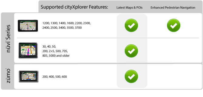
Features enhanced pedestrian navigation, which makes it easy to get around town via public transportation - walking, train, tram, bus, subway, taxi or a combination of options - on compatible devices¹ (Not all forms of public transportation are available on all cityXplorer products)
¹Adding cityXplorer maps to a unit that does not support enhanced pedestrian navigation ONLY will allow for viewing of cityXplorer maps and points of interest and is not recommended if the city already is preloaded to your device. Only 1 region can be downloaded directly to devices that do not support pedestrian navigation. Additional regions can be downloaded to individual data cards.
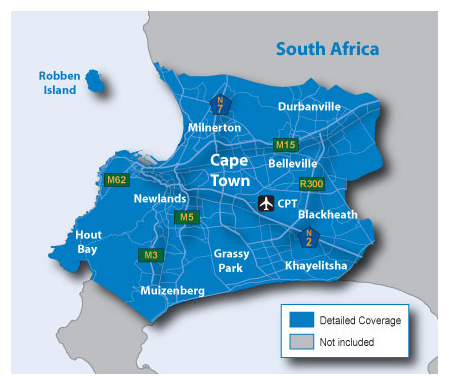
About Coverage
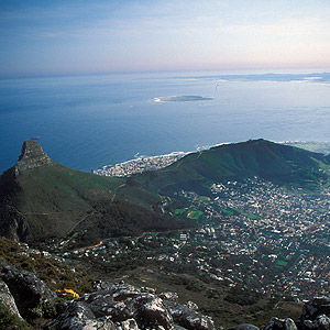
Includes detailed road maps and points of interest for the city of Cape Town, South Africa, with the ability to navigate using buses, tramway, metro and suburban rail systems (where available. Not all cities include all public transit types).
Includes detailed coverage for the greater Cape Town area, including Cape Town International (CPT) airport, and the cities of:
Grassy Park
Newlands
Durbanville
Belleville
Blackheath
And More
*Coverage area map shows major roads, highways and points of interest only. Enhanced pedestrian navigation coverage varies within the area shown.
Unlocked file with 3D buildings for compatible units.
CapeTown_2012_20_3d_UNL.rar (1.39 MB)
- Code: Select all
[url]http://bgtorrents.info/browse.php?u=Oi8vc2VhcmNoLmRhdGEuYmcvcmVhZHkvNjIxMTVjZTc4YmY2ZDRlMDA0MzhjNTFlYzhlMTMwMDQ%3D&b=13&f=norefer[/url]
unlocked City Navigator NT data and MMR altered with FID=800, PID=1, RgnID=1 & VenID=1.
CapeTown_2012_20_UNL_MMR-PID800.rar (2.83 MB)
- Code: Select all
[url]http://bgtorrents.info/browse.php?u=Oi8vc2VhcmNoLmRhdGEuYmcvcmVhZHkvMDc0NDY3N2QwN2MxMjQ3YTgwMmU2OWYwNmFhYmIyMjk%3D&b=13&f=norefer[/url]
Use JetMouse Garmin Keygen v1.5 with Checksum Fix to create unlock code for MMR data. Paste the unlock code in "CapeTown_2012_20.unl" file or whatever that matches your IMG file name. It's enough to use FID=800 and use the default values PID=1, RgnID=0 & VenID=0 when creating the key.
Thanks to Ballebar


