Bluechart - VUS010R-Southeast Florida V10.50 G2 Vision Map
Thu Jun 24, 2010 11:56 pm
[SIZE="4"]Bluechart - VUS010R-Southeast Florida V10.50 G2 Vision Map[/size]
Description:
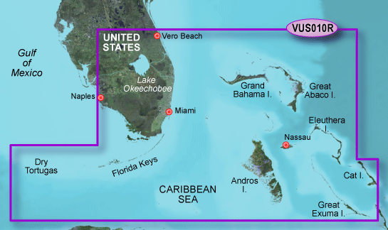
Garmin VUS010R Bluechart G2 Vision Southeast Florida - SD Card. FEATURING DATA FROM EXPLORER CHARTS FOR THE BAHAMAS!!! Vero Beach south to include Lake Okeechobee, Florida Keys, Dry Tortugas, and covering the west coast of Florida north to Naples. Also covered all the Bahamas, Andros Island, Eleuthera Island, Cat Island, Great Exuma Island, Little Exuma Island, and Hog Cay.Card Format SD Port Plans Yes Aerial Photo Yes 3-D View Yes
[Please Register or Login to download file] (300 MB)
[Please Register or Login to download file] (300 MB)
[Please Register or Login to download file] (97,6 MB)
[Please Register or Login to download file] (100 MB)
[Please Register or Login to download file] (100 MB)
[Please Register or Login to download file] (100 MB)
[Please Register or Login to download file] (100 MB)
[Please Register or Login to download file] (100 MB)
[Please Register or Login to download file] (100 MB)
[Please Register or Login to download file] (97.6 MB)
Description:
Garmin VUS010R Bluechart G2 Vision Southeast Florida - SD Card. FEATURING DATA FROM EXPLORER CHARTS FOR THE BAHAMAS!!! Vero Beach south to include Lake Okeechobee, Florida Keys, Dry Tortugas, and covering the west coast of Florida north to Naples. Also covered all the Bahamas, Andros Island, Eleuthera Island, Cat Island, Great Exuma Island, Little Exuma Island, and Hog Cay.Card Format SD Port Plans Yes Aerial Photo Yes 3-D View Yes
[Please Register or Login to download file] (300 MB)
[Please Register or Login to download file] (300 MB)
[Please Register or Login to download file] (97,6 MB)
[Please Register or Login to download file] (100 MB)
[Please Register or Login to download file] (100 MB)
[Please Register or Login to download file] (100 MB)
[Please Register or Login to download file] (100 MB)
[Please Register or Login to download file] (100 MB)
[Please Register or Login to download file] (100 MB)
[Please Register or Login to download file] (97.6 MB)