BlueChart g2 Vision: VUS517L - Alaska South v2011.5 (v13.00)
Thu Aug 30, 2012 7:07 pm
BlueChart g2 Vision: VUS517L - Alaska South v2011.5 (v13.00)
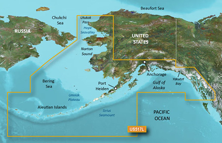
Detailed coverage of Alaska, from Prince of Wales Island to Point Lay on the north slope, including Glacier Bay, the Kenai Peninsula, and the Aleutian Chain in full. Bathymetric coverage of the Gulf of Alaska, Bristol Bay and United States waters in the Chukchi and Bering Seas, and along the entire Aleutian chain including Akutan Pass Umnak Plateau, Zhemchug Canyon, Chirikof Basin, and Hope Seavalley.
info
PID 1, FID 2463, region 4,34
thanks to Ballebar
Detailed coverage of Alaska, from Prince of Wales Island to Point Lay on the north slope, including Glacier Bay, the Kenai Peninsula, and the Aleutian Chain in full. Bathymetric coverage of the Gulf of Alaska, Bristol Bay and United States waters in the Chukchi and Bering Seas, and along the entire Aleutian chain including Akutan Pass Umnak Plateau, Zhemchug Canyon, Chirikof Basin, and Hope Seavalley.
info
- Code:
https://buy.garmin.com/shop/shop.do?pID=9281
PID 1, FID 2463, region 4,34
- Code:
[url=http://www7.zippyshare.com/v/95097103/file.html]gmapsupp.part01.rar[/url]
[url=http://www36.zippyshare.com/v/67013149/file.html]gmapsupp.part02.rar[/url]
[url=http://www36.zippyshare.com/v/89449320/file.html]gmapsupp.part03.rar[/url]
[url=http://www36.zippyshare.com/v/14322883/file.html]gmapsupp.part04.rar[/url]
[url=http://www36.zippyshare.com/v/20193315/file.html]gmapsupp.part05.rar[/url]
[url=http://www36.zippyshare.com/v/43821796/file.html]gmapsupp.part06.rar[/url]
[url=http://www36.zippyshare.com/v/50290580/file.html]gmapsupp.part07.rar[/url]
[url=http://www36.zippyshare.com/v/36987393/file.html]gmapsupp.part08.rar[/url]
[url=http://www36.zippyshare.com/v/71239006/file.html]gmapsupp.part09.rar[/url]
[url=http://www36.zippyshare.com/v/11877234/file.html]gmapsupp.part10.rar[/url]
thanks to Ballebar
Re: BlueChart g2 Vision: VUS517L - Alaska South v2011.5 (v13
Thu Jul 28, 2016 12:57 am
All inks broke.
Any chance these could be re-upped?
Any chance these could be re-upped?
Re: BlueChart g2 Vision: VUS517L - Alaska South v2011.5 (v13
Sat May 24, 2025 12:32 am
Re-upload???