BlueChart g2 Vision VUS515L Brownsville-Key Largo v2015.50 (v.17.00)   

BlueChart g2 Vision VUS515L Brownsville-Key Largo v2015.50 (v.17.00)

Postby huntsman » Tue Mar 01, 2016 10:35 am

BlueChart g2 Vision VUS515L Brownsville-Key Largo v2015.50 (v.17.00)

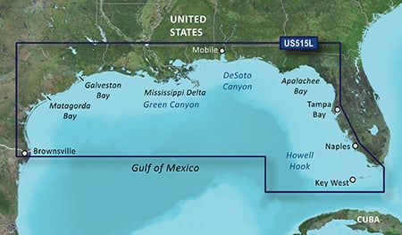
Detailed coverage of the Gulf of Mexico from Brownsville, TX to Plantation Key, FL including Corpus Christi, TX, Matagorda Bay, Galveston Bay, Port Arthur, TX, Atchafalaya Bay, the Mississippi Delta, Chandeleur Islands, Tampa Bay and the Florida Keys west of Key Largo. Also includes Lake Ponchartrain and Lake Maurepas to Vermilion Bay and Lake Calcasieu. Bathymetric coverage of offshore features from Northwest Slope to Tortugas Terrace including Keathley Canyon, Green Canyon, Orca Basin, Mississippi Canyon, Southwest Pass, DeSoto Canyon, Florida Middle Ground, Howell Hook, and Tortugas Bank.

FID 3847, PID 1, region 4,32

Dowmload:
Locked: [Please Register or Login to download file]
Image

UnLocked: [Please Register or Login to download file]
Image


Image
Code: Select all
https://buy.garmin.com/en-US/US/prod8810.html
huntsman offline


User avatar Elite Member


Joined: Fri Sep 17, 2010 8:58 pm
Posts: 970
Has thanked: 2 times
Been thanked: 1295 times

Re: BlueChart g2 Vision VUS515L Brownsville-Key Largo v2015.50 (v.17.00)

Postby bam-bam » Tue Mar 01, 2016 2:51 pm

unl.img
This board requires you to be registered and logged-in to view hidden content.


This board requires you to be registered and logged-in to view hidden content.
bam-bam offline


User avatar Ex Moderator


Joined: Fri Jul 23, 2010 9:43 pm
Posts: 1420
Location: .BG
Has thanked: 51 times
Been thanked: 2004 times
Age: 44


Return to New Maps


  • Related topics
    Replies
    Views
    Last post

Who is online

Users browsing this forum: Depyke and 6 guests