Forum
Forum
See your vessel’s precise, on-chart position in relation to navaids, coastal features and restricted areas with premium features found in this detailed marine mapping data. Includes all of the features of our BlueChart® g2 product, plus 3-D perspective above and below the waterline, Auto Guidance, high-resolution imagery, and aerial photos of ports, harbors, marinas and landmarks.
- Shaded depth contours, coastlines, spot soundings, navaids, port plans, wrecks, obstructions, intertidal zones, restricted areas and IALA symbols.
- Seamless transitions between zoom levels and more continuity across chart boundaries.
- High resolution satellite imagery for a realistic view of the land and water.
- Aerial photos of ports, harbors, marinas, waterways, navigational landmarks and other POIs.
- Auto Guidance technology searches chart data to suggest the best passage to a destination.
- MarinerEye view 3-D perspective for a quick, easy position fix.
- FishEye view 3-D perspective for an underwater view of the sea floor.
- Safety Shading* enables contour shading for all depth contours shallower than your defined safe depths.
- Fishing Charts* to scope out bottom contours and depth soundings with less visual clutter on the display.
- Plan and organize routes from your computer with HomePort™ (sold separately).
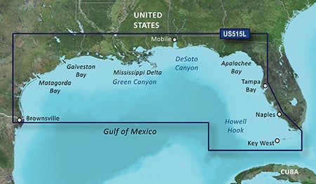
Detailed coverage of the Gulf of Mexico from Brownsville, TX to Plantation Key, FL including Corpus Christi, TX, Matagorda Bay, Galveston Bay, Port Arthur, TX, Atchafalaya Bay, the Mississippi Delta, Chandeleur Islands, Tampa Bay and the Florida Keys west of Key Largo. Also includes Lake Ponchartrain and Lake Maurepas to Vermilion Bay and Lake Calcasieu. Bathymetric coverage of offshore features from Northwest Slope to Tortugas Terrace including Keathley Canyon, Green Canyon, Orca Basin, Mississippi Canyon, Southwest Pass, DeSoto Canyon, Florida Middle Ground, Howell Hook, and Tortugas Bank.
2824, PID: 1, RID: 4, VID: 32
Locked Image:
UnLocked Image:
- Code: Select all
https://buy.garmin.com/en-US/US/prod8810.html