BlueChart g2 Vision: VUS512L - Mid-Atlantic v2011.5 (v13.00)
Wed Jul 25, 2012 9:24 pm
VUS512L - Mid-Atlantic v2011.5 (v13.00)
info:
Version: 2011.5
Released: Aug, 2011
Part Number: 010-C0741-00 (microSD/SD), 010-D0500-00 (Download)
See your vessel’s precise, on-chart position in relation to navaids, coastal features, restricted areas and more with premium features found in this detailed marine mapping data. Includes all of the BlueChart® g2 features, plus 3-D perspective above and below the waterline, Auto Guidance, high-resolution imagery, and aerial photos of ports, harbors, marinas, landmarks and other points of interest.
Features
Includes realistic navigation features showing everything from shaded depth contours and coastlines to spot soundings, navaids, port plans, wrecks, obstructions, intertidal zones, restricted areas, IALA symbols and more.
Features smooth displays, including seamless transitions between zoom levels and more continuity across chart boundaries.
Includes high-resolution satellite imagery, when overlaid on the chart, provides the mariner with a realistic view of the land and water for unparalleled situational awareness.
Features aerial “real world” photos of ports, harbors, marinas, waterways, navigational landmarks and other points of interest, offering the mariner another powerful tool for navigating unfamiliar waters.
Includes Auto Guidance technology that searches chart data - tides, currents, marine services, coastal roads and points of interest - to suggest the best passage to a destination.
Offers MarinerEye view 3-D perspective, providing a bird's eye view from behind the boat showing the chart information for a quick, reliable and easy position fix.
Offers FishEye view 3-D perspective, providing an underwater view that visually represents the sea floor according to the chart's information.
Provides Safety Shading (in compatible units), allowing mariners to enable contour shading for all depth contours shallower than user-defined safe depths.
Provides Fishing Charts (in compatible units), allowing mariners to scope out bottom contours and depth soundings with less visual clutter on the display.
Allows users to conveniently plan and organize routes, from your computer, before your trip with HomePort™, compatible trip-planning software (sold separately).
.
Coverage Details
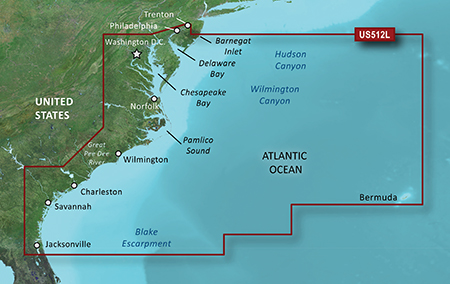
Coverage of the east Coast from Barnegat Inlet, NJ through Jacksonville, FL, to Bermuda. Coverage includes the Delaware River to Trenton, NJ; the Chesepeake Bay in full; the Albemarle and Pamlico Sounds in full; Cape Fear, NC; the Savannah R. to Augusta, GA; and the St. Johns R. to Hastings, FL. Bathymetric coverage from Hudson Canyon to the Blake Escarpment, including the Wilmington, Baltimore and Washington Canyons, Charleston Valley, and the Savannah Seachannel.
Thanks to Ballebar
info:
- Code:
https://buy.garmin.com/shop/shop.do?pID=8807
Version: 2011.5
Released: Aug, 2011
Part Number: 010-C0741-00 (microSD/SD), 010-D0500-00 (Download)
See your vessel’s precise, on-chart position in relation to navaids, coastal features, restricted areas and more with premium features found in this detailed marine mapping data. Includes all of the BlueChart® g2 features, plus 3-D perspective above and below the waterline, Auto Guidance, high-resolution imagery, and aerial photos of ports, harbors, marinas, landmarks and other points of interest.
Features
Includes realistic navigation features showing everything from shaded depth contours and coastlines to spot soundings, navaids, port plans, wrecks, obstructions, intertidal zones, restricted areas, IALA symbols and more.
Features smooth displays, including seamless transitions between zoom levels and more continuity across chart boundaries.
Includes high-resolution satellite imagery, when overlaid on the chart, provides the mariner with a realistic view of the land and water for unparalleled situational awareness.
Features aerial “real world” photos of ports, harbors, marinas, waterways, navigational landmarks and other points of interest, offering the mariner another powerful tool for navigating unfamiliar waters.
Includes Auto Guidance technology that searches chart data - tides, currents, marine services, coastal roads and points of interest - to suggest the best passage to a destination.
Offers MarinerEye view 3-D perspective, providing a bird's eye view from behind the boat showing the chart information for a quick, reliable and easy position fix.
Offers FishEye view 3-D perspective, providing an underwater view that visually represents the sea floor according to the chart's information.
Provides Safety Shading (in compatible units), allowing mariners to enable contour shading for all depth contours shallower than user-defined safe depths.
Provides Fishing Charts (in compatible units), allowing mariners to scope out bottom contours and depth soundings with less visual clutter on the display.
Allows users to conveniently plan and organize routes, from your computer, before your trip with HomePort™, compatible trip-planning software (sold separately).
.
Coverage Details
Coverage of the east Coast from Barnegat Inlet, NJ through Jacksonville, FL, to Bermuda. Coverage includes the Delaware River to Trenton, NJ; the Chesepeake Bay in full; the Albemarle and Pamlico Sounds in full; Cape Fear, NC; the Savannah R. to Augusta, GA; and the St. Johns R. to Hastings, FL. Bathymetric coverage from Hudson Canyon to the Blake Escarpment, including the Wilmington, Baltimore and Washington Canyons, Charleston Valley, and the Savannah Seachannel.
- Code:
[url]http://mir.cr/0RHNNR6A[/url]
[url]http://mir.cr/0A63P5NT[/url]
[url]http://mir.cr/KSTWQR6A[/url]
[url]http://mir.cr/6AJPMWF7[/url]
[url]http://mir.cr/1EBQJKAU[/url]
[url]http://mir.cr/0X4YTNDE[/url]
[url]http://mir.cr/0F0QWAN3[/url]
[url]http://mir.cr/BICUTA69[/url]
Thanks to Ballebar
Re: BlueChart g2 Vision: VUS512L - Mid-Atlantic v2011.5 (v13
Sun Sep 05, 2021 11:07 am
please re-upload
Re: BlueChart g2 Vision: VUS512L - Mid-Atlantic v2011.5 (v13
Sun Sep 05, 2021 7:22 pm
Newer version re-uploaded new-maps/bluechart-vision-vus512l-mid-atlantic-2014-t17098.html