BlueChart g2 Vision - VEU712L - Sweden East & Gulf of Finland 2015.5 (17.00)
Sun Jun 22, 2014 9:42 pm
BlueChart g2 Vision - VEU712L - Sweden East & Gulf of Finland 2015.5 (17.00)
See your vessel’s precise, on-chart position in relation to navaids, coastal features and restricted areas with premium features found in this detailed marine mapping data. Includes all of the features of our BlueChart® g2 product, plus 3-D perspective above and below the waterline, Auto Guidance, high-resolution imagery, and aerial photos of ports, harbors, marinas and landmarks.
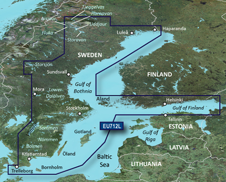
Detailed coverage of the coast of Sweden along the Baltic Sea and Gulf of Bothnia from Trelleborg to Haparanda including Kristianstad, Stockholm, Sundsvall, and Luleå; also coastal coverage of Finland's Gulf of Finland from Uusikaupunki to Vyborg, RU including Turku, Hanko, and Helsinki. Swedish lake coverage features Vättern, Sommen, Nommen, Revsundssjön, Hjälmaren, Siljan, Mälaren, Storsjön, Storavan, Uddjaur, Hornovan, Tjeggelvas, Aisjaur, Fluka, Helgasjön, and Bolmen, as well as coverage of the lower Dalälven from Gysinge to Söderfors. Island coverage features Bornholm, Oland, Gotland, and Åland.
FID: 3850, PID: 1, RID: 4, VID: 18
Locked Image:
UnLocked Image:
See your vessel’s precise, on-chart position in relation to navaids, coastal features and restricted areas with premium features found in this detailed marine mapping data. Includes all of the features of our BlueChart® g2 product, plus 3-D perspective above and below the waterline, Auto Guidance, high-resolution imagery, and aerial photos of ports, harbors, marinas and landmarks.
- Shaded depth contours, coastlines, spot soundings, navaids, port plans, wrecks, obstructions, intertidal zones, restricted areas and IALA symbols.
- Seamless transitions between zoom levels and more continuity across chart boundaries.
- High resolution satellite imagery for a realistic view of the land and water.
- Aerial photos of ports, harbors, marinas, waterways, navigational landmarks and other POIs.
- Auto Guidance technology searches chart data to suggest the best passage to a destination.
- MarinerEye view 3-D perspective for a quick, easy position fix.
- FishEye view 3-D perspective for an underwater view of the sea floor.
- Safety Shading* enables contour shading for all depth contours shallower than your defined safe depths.
- Fishing Charts* to scope out bottom contours and depth soundings with less visual clutter on the display.
- Plan and organize routes from your computer with HomePort™ (sold separately).
Detailed coverage of the coast of Sweden along the Baltic Sea and Gulf of Bothnia from Trelleborg to Haparanda including Kristianstad, Stockholm, Sundsvall, and Luleå; also coastal coverage of Finland's Gulf of Finland from Uusikaupunki to Vyborg, RU including Turku, Hanko, and Helsinki. Swedish lake coverage features Vättern, Sommen, Nommen, Revsundssjön, Hjälmaren, Siljan, Mälaren, Storsjön, Storavan, Uddjaur, Hornovan, Tjeggelvas, Aisjaur, Fluka, Helgasjön, and Bolmen, as well as coverage of the lower Dalälven from Gysinge to Söderfors. Island coverage features Bornholm, Oland, Gotland, and Åland.
FID: 3850, PID: 1, RID: 4, VID: 18
Locked Image:
UnLocked Image:
- Code:
https://buy.garmin.com/en-US/US/maps/prod8830_010-C0859-00.html
Last edited by huntsman on Mon Mar 14, 2016 10:36 pm, edited 2 times in total.
Re: BlueChart g2 Vision - VEU712L - Sweden East & Gulf of Finland 2014.0 (15.50)
Wed Jun 25, 2014 3:29 pm