BlueChart g2 Vision - VEU711L - Sweden South 2014.0 (15.50)
Thu Jun 19, 2014 10:03 pm
BlueChart g2 Vision - VEU711L - Sweden South 2014.0 (15.50)
Part Number: MicroSD/SD (010-C0858-00), Download (010-D0506-00)
See your vessel’s precise, on-chart position in relation to navaids, coastal features and restricted areas with premium features found in this detailed marine mapping data. Includes all of the features of our BlueChart® g2 product, plus 3-D perspective above and below the waterline, Auto Guidance, high-resolution imagery, and aerial photos of ports, harbors, marinas and landmarks.
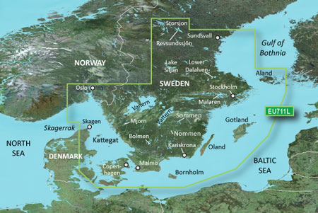
Detailed coverage of southern Sweden from Oslo, NO to Sundsvall, SE including Malmo and Stockholm, Lakes Vänern, Vättern, Hjälmaren, Mälaren, Storsjön, Fryken, Mjörn, Revsundssjön, Sommen, Nommen, Helgasjön and Bolmen as well as coverage of the lower Dalälven from Gysinge to Söderfors. Coverage also includes the Oslofjorden, the Kattegat and the islands of Bornholm, Oland, Gotland, and Åland. Also includes the eastern coast of Denmark from Skagen to Copenhagen including Svendborg and Nykøbing.
FID: 3248, PID: 1, RID: 4, VID: 17
Locked Image:
UnLocked Image:
Part Number: MicroSD/SD (010-C0858-00), Download (010-D0506-00)
See your vessel’s precise, on-chart position in relation to navaids, coastal features and restricted areas with premium features found in this detailed marine mapping data. Includes all of the features of our BlueChart® g2 product, plus 3-D perspective above and below the waterline, Auto Guidance, high-resolution imagery, and aerial photos of ports, harbors, marinas and landmarks.
- Shaded depth contours, coastlines, spot soundings, navaids, port plans, wrecks, obstructions, intertidal zones, restricted areas and IALA symbols.
- Seamless transitions between zoom levels and more continuity across chart boundaries.
- High resolution satellite imagery for a realistic view of the land and water.
- Aerial photos of ports, harbors, marinas, waterways, navigational landmarks and other POIs.
- Auto Guidance technology searches chart data to suggest the best passage to a destination.
- MarinerEye view 3-D perspective for a quick, easy position fix.
- FishEye view 3-D perspective for an underwater view of the sea floor.
- Safety Shading* enables contour shading for all depth contours shallower than your defined safe depths.
- Fishing Charts* to scope out bottom contours and depth soundings with less visual clutter on the display.
- Plan and organize routes from your computer with HomePort™ (sold separately).
Detailed coverage of southern Sweden from Oslo, NO to Sundsvall, SE including Malmo and Stockholm, Lakes Vänern, Vättern, Hjälmaren, Mälaren, Storsjön, Fryken, Mjörn, Revsundssjön, Sommen, Nommen, Helgasjön and Bolmen as well as coverage of the lower Dalälven from Gysinge to Söderfors. Coverage also includes the Oslofjorden, the Kattegat and the islands of Bornholm, Oland, Gotland, and Åland. Also includes the eastern coast of Denmark from Skagen to Copenhagen including Svendborg and Nykøbing.
FID: 3248, PID: 1, RID: 4, VID: 17
Locked Image:
UnLocked Image:
- Code:
https://buy.garmin.com/en-US/US/maps/nauticka-kartografija/bluechart-g2-vision-interactive-maps/veu711l-sweden-south/prod8829.html
Re: BlueChart g2 Vision - VEU711L - Sweden South 2014.0 (15.50)
Tue Jun 24, 2014 7:31 pm
Re: BlueChart g2 Vision - VEU711L - Sweden South 2014.0 (15.
Tue Feb 18, 2025 3:25 pm
Hi.
Old post, can someone plz upload a working link. My card is broken
regards
Old post, can someone plz upload a working link. My card is broken
regards