BlueChart g2 Vision - VEU010R - Mediterranean Sea, Genova-Ayamonte 2014.0 (15.50)
Sat Oct 11, 2014 9:43 am
BlueChart g2 Vision - VEU010R - Mediterranean Sea, Genova-Ayamonte 2014.0 (15.50)
See your vessel’s precise, on-chart position in relation to navaids, coastal features and restricted areas with premium features found in this detailed marine mapping data. Includes all of the features of our BlueChart® g2 product, plus 3-D perspective above and below the waterline, Auto Guidance, high-resolution imagery, and aerial photos of ports, harbors, marinas and landmarks.
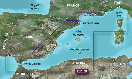
Detailed coverage of the entire Spanish and French Mediterranean coast from the Straight of Gibraltar to La Spezia, IT. Includes coverage of Corse, the northern part of Sardegna, and the Islas Baleares. Also covers the northern coasts of Morocco and Algeria from Larache, MA, to Bejaia, DZ.
FID: 3247, PID: 1, RID: 2, VID: 16
Locked Image:
UnLocked Image:
See your vessel’s precise, on-chart position in relation to navaids, coastal features and restricted areas with premium features found in this detailed marine mapping data. Includes all of the features of our BlueChart® g2 product, plus 3-D perspective above and below the waterline, Auto Guidance, high-resolution imagery, and aerial photos of ports, harbors, marinas and landmarks.
- Shaded depth contours, coastlines, spot soundings, navaids, port plans, wrecks, obstructions, intertidal zones, restricted areas and IALA symbols.
- Seamless transitions between zoom levels and more continuity across chart boundaries.
- High resolution satellite imagery for a realistic view of the land and water.
- Aerial photos of ports, harbors, marinas, waterways, navigational landmarks and other POIs.
- Auto Guidance technology searches chart data to suggest the best passage to a destination.
- MarinerEye view 3-D perspective for a quick, easy position fix.
- FishEye view 3-D perspective for an underwater view of the sea floor.
- Safety Shading* enables contour shading for all depth contours shallower than your defined safe depths.
- Fishing Charts* to scope out bottom contours and depth soundings with less visual clutter on the display.
- Plan and organize routes from your computer with HomePort™ (sold separately).
Detailed coverage of the entire Spanish and French Mediterranean coast from the Straight of Gibraltar to La Spezia, IT. Includes coverage of Corse, the northern part of Sardegna, and the Islas Baleares. Also covers the northern coasts of Morocco and Algeria from Larache, MA, to Bejaia, DZ.
FID: 3247, PID: 1, RID: 2, VID: 16
Locked Image:
UnLocked Image:
- Code:
https://buy.garmin.com/en-US/US/maps/prod9187.html
Re: BlueChart g2 Vision - VEU010R - Mediterranean Sea, Genova-Ayamonte 2014.0 (15.50)
Sun Oct 26, 2014 10:33 am