BlueChart g2 Vision - VAE005R - Philippines-Java-Mariana Is. 2014.0 (15.50)
Thu Mar 27, 2014 1:49 am
BlueChart g2 Vision - VAE005R - Philippines-Java-Mariana Is. 2014.0 (15.50)
Part Number: MicroSD/SD (010-C1103-00), Download (010-D1340-00)
See your vessel’s precise, on-chart position in relation to navaids, coastal features and restricted areas with premium features found in this detailed marine mapping data. Includes all of the features of our BlueChart® g2 product, plus 3-D perspective above and below the waterline, Auto Guidance, high-resolution imagery, and aerial photos of ports, harbors, marinas and landmarks.
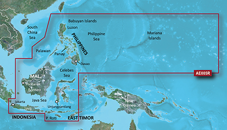
General coverage of the coasts of the Philippines, portions of Indonesia, including Java, and Malaysia located to the east of Singapore and west of Halmahera Island, and portions of East Timor. Included in this overall general coverage are numerous detailed charts covering areas such as the Indonesian cities of Jakarta, Semarang, and Ujungpandang, Manila, Phil., Kota Kinabalu, Mal., and Bandar Seri Begawan, Brun. General coverage of the Mariana Islands is also included.
FID: 3250, PID: 1, RID: 3, VID: 5
Locked Image:
UnLocked Image:
Part Number: MicroSD/SD (010-C1103-00), Download (010-D1340-00)
See your vessel’s precise, on-chart position in relation to navaids, coastal features and restricted areas with premium features found in this detailed marine mapping data. Includes all of the features of our BlueChart® g2 product, plus 3-D perspective above and below the waterline, Auto Guidance, high-resolution imagery, and aerial photos of ports, harbors, marinas and landmarks.
- Shaded depth contours, coastlines, spot soundings, navaids, port plans, wrecks, obstructions, intertidal zones, restricted areas and IALA symbols.
- Seamless transitions between zoom levels and more continuity across chart boundaries.
- High resolution satellite imagery for a realistic view of the land and water.
- Aerial photos of ports, harbors, marinas, waterways, navigational landmarks and other POIs.
- Auto Guidance technology searches chart data to suggest the best passage to a destination.
- MarinerEye view 3-D perspective for a quick, easy position fix.
- FishEye view 3-D perspective for an underwater view of the sea floor.
- Safety Shading* enables contour shading for all depth contours shallower than your defined safe depths.
- Fishing Charts* to scope out bottom contours and depth soundings with less visual clutter on the display.
- Plan and organize routes from your computer with HomePort™ (sold separately).
General coverage of the coasts of the Philippines, portions of Indonesia, including Java, and Malaysia located to the east of Singapore and west of Halmahera Island, and portions of East Timor. Included in this overall general coverage are numerous detailed charts covering areas such as the Indonesian cities of Jakarta, Semarang, and Ujungpandang, Manila, Phil., Kota Kinabalu, Mal., and Bandar Seri Begawan, Brun. General coverage of the Mariana Islands is also included.
FID: 3250, PID: 1, RID: 3, VID: 5
Locked Image:
[Please Register or Login to download file] | [Please Register or Login to download file] | [Please Register or Login to download file] | [Please Register or Login to download file] | [Please Register or Login to download file] | [Please Register or Login to download file] | [Please Register or Login to download file]
UnLocked Image:
[Please Register or Login to download file] | [Please Register or Login to download file] | [Please Register or Login to download file] | [Please Register or Login to download file] | [Please Register or Login to download file] | [Please Register or Login to download file] | [Please Register or Login to download file]
- Code:
https://buy.garmin.com/en-US/digital/maps/on-the-water-maps/bluechart-g2-vision-interactive-maps/vae005r-philippines-java-mariana-is-/prod9275.html
Re: BlueChart g2 Vision - VAE005R - Philippines-Java-Mariana Is. 2014.0 (15.50)
Mon Mar 31, 2014 1:23 pm
Re: BlueChart g2 Vision - VAE005R - Philippines-Java-Mariana Is. 2014.0 (15.50)
Tue Sep 15, 2015 12:39 am
Thank you very much for sharing...
Re: BlueChart g2 Vision - VAE005R - Philippines-Java-Mariana Is. 2014.0 (15.50)
Tue Sep 15, 2015 12:48 am
links not working...please re upload...thanks
Re: Garmin map requests without existing thread
Thu Mar 30, 2023 2:01 am
Hi guys !
I am sailing in Asia and I just discovered my VAE005R - Philippines-Java-Mariana Is (v 14.01) is corrupted or something like that. Size is 3,40 Go (3 656 384 512 bits). I was sailing on VAE009R - Sin-Mal-Indonesia 2012.1, which is ok, and now I am in trouble.
Can anybody give me a link, anything can help ? I've got many, many Bluecharts G2 I can provide in exchange ...
TIA
Gus
Re: BlueChart g2 Vision - VAE005R - Philippines-Java-Mariana
Thu Mar 30, 2023 1:35 pm
GUSDRAS wrote:Hi guys !
I am sailing in Asia and I just discovered my VAE005R - Philippines-Java-Mariana Is (v 14.01) is corrupted or something like that. Size is 3,40 Go (3 656 384 512 bits). I was sailing on VAE009R - Sin-Mal-Indonesia 2012.1, which is ok, and now I am in trouble.
Can anybody give me a link, anything can help ? I've got many, many Bluecharts G2 I can provide in exchange ...
TIA
Gus
I can upload it after the weekend when I am back home. In the meantime please upload some of your maps to share on the forum.