BlueChart G2 - Seamaps Europe
Tue Oct 11, 2011 3:24 am
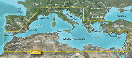
[SIZE="4"]HEU718L - Mediterranean Sea v2011.5 (v13.00)[/size]
Version: 2011.5
Released: Aug, 2011
Credit to [color="sienna"]Ballebar[/color]
Features
Detailed offshore coastal coverage of the Mediterranean Sea in its entirety. Coverage features the Strait of Gibraltar, the Balearic Islands, the French Riviera, Corsica, Sardinia, Sicily, the Adriatic Sea, the Greek Islands, the Aegean Sea, the Dardanelles and Bosporus Straits, the Sea of Marmara, Cyprus, the Suez Canal, Tripoli and Algiers Harbors, and the Gulfs of Gabès and Tunisia.
Coverage Details
Detailed offshore coastal coverage of the Mediterranean Sea in its entirety. Coverage features the Strait of Gibraltar, the Balearic Islands, the French Riviera, Corsica, Sardinia, Sicily, the Adriatic Sea, the Greek Islands, the Aegean Sea, the Dardanelles and Bosporus Straits, the Sea of Marmara, Cyprus, the Suez Canal, Tripoli and Algiers Harbors, and the Gulfs of Gabès and Tunisia.
MapID: [color="sienna"]2457[/color]
Download [color="sienna"]Locked[/color] Image:
[Please Register or Login to download file] ( 300.00 MB )
[Please Register or Login to download file] ( 258.55 MB )
or
[Please Register or Login to download file] ( 300.00 MB )
[Please Register or Login to download file] ( 258.55 MB )
Download [color="sienna"]UnLocked[/color] Image:
[Please Register or Login to download file] ( 300.00 MB )
[Please Register or Login to download file] ( 258.55 MB )
or
[Please Register or Login to download file] ( 300.00 MB )
[Please Register or Login to download file] ( 258.55 MB )
Garmin info:

Version: 2011.5
Released: Aug, 2011
Credit to [color="sienna"]Ballebar[/color]
Features
Detailed offshore coastal coverage of the Mediterranean Sea in its entirety. Coverage features the Strait of Gibraltar, the Balearic Islands, the French Riviera, Corsica, Sardinia, Sicily, the Adriatic Sea, the Greek Islands, the Aegean Sea, the Dardanelles and Bosporus Straits, the Sea of Marmara, Cyprus, the Suez Canal, Tripoli and Algiers Harbors, and the Gulfs of Gabès and Tunisia.
Coverage Details
Detailed offshore coastal coverage of the Mediterranean Sea in its entirety. Coverage features the Strait of Gibraltar, the Balearic Islands, the French Riviera, Corsica, Sardinia, Sicily, the Adriatic Sea, the Greek Islands, the Aegean Sea, the Dardanelles and Bosporus Straits, the Sea of Marmara, Cyprus, the Suez Canal, Tripoli and Algiers Harbors, and the Gulfs of Gabès and Tunisia.
MapID: [color="sienna"]2457[/color]
Download [color="sienna"]Locked[/color] Image:
[Please Register or Login to download file] ( 300.00 MB )
[Please Register or Login to download file] ( 258.55 MB )
or
[Please Register or Login to download file] ( 300.00 MB )
[Please Register or Login to download file] ( 258.55 MB )
Download [color="sienna"]UnLocked[/color] Image:
[Please Register or Login to download file] ( 300.00 MB )
[Please Register or Login to download file] ( 258.55 MB )
or
[Please Register or Login to download file] ( 300.00 MB )
[Please Register or Login to download file] ( 258.55 MB )
- Code:
Header:      19.07.2011 12:51:03, DSKIMG, XOR 00, V 13.00, Ms 0
Mapset:      HXEU718L-Mediterranean Sea v2011.5
fat:      1000h - 1200h - 24000h, block 16384
maps:      47, sub-files 138

Sub-file         fat     length
 MARINAS  MDR   1200h     34771
 MARINAS  SRT   1400h       968
 F0000027 RGN   1600h   1257833
 F0000027 LBL   1800h       607
   CP 1252, Western European
 F0000027 TRE   1A00h     14012
   map 7f63fe (8348670)
   [color="#FF0000"]PID 1, FID 2457, region 4,24[/color]
   date 08.07.2011 18:31:01
   priority 28, parameters 1 6 29 19, [color="#FF0000"]locked[/color], transparent
   N: 35.315166, S: 29.844360, W: -3.720031, E: 2.048521
   GARMIN G-Map
Garmin info:
- Code:
https://buy.garmin.com/shop/shop.do?pID=51204&pvID=39104
Mon Jul 02, 2012 5:48 pm
try this
or
- Code:
[url]http://www.shragle.com/files/9292f4c8/HEU718L.part1.rar[/url]
[url]http://www6.zippyshare.com/v/52374602/file.html[/url]
or
- Code:
[url]http://ul.to/efzewefb[/url]
[url]http://ul.to/005jvyjb[/url]
[url]http://ul.to/6opach0f[/url]
BlueChart g2 - HEU050R - Gulfs of Finland & Riga (v13.52)
Tue Jul 03, 2012 10:35 pm
BlueChart g2 - HEU050R - Gulfs of Finland & Riga (v13.52)
Version: 2012.2
Released: Mar 2012
Part Number: 010-D0299-00
See your vessel’s precise, on-chart position in relation to navaids, coastal features, anchorages, obstructions, waterways, restricted areas and more with this detailed marine mapping data. Also includes Safety Shading and Fishing Charts (in compatible units), smooth data transition between zoom levels, harmonious transition across chart borders and reduction of chart discontinuities in coverage areas.
Includes realistic navigation features showing everything from shaded depth contours and coastlines to spot soundings, navaids, port plans, wrecks, obstructions, intertidal zones, restricted areas, IALA symbols and more.
Features smooth displays, including seamless transitions between zoom levels and more continuity across chart boundaries.
Allows users to choose between standard 2-D direct overhead or 3-D "over the bow" map perspective to make chart reading and orientation easier.
Provides Safety Shading (in compatible units), allowing mariners to enable contour shading for all depth contours shallower than user-defined safe depths.
Provides Fishing Charts (in compatible units), allowing mariners to scope out bottom contours and depth soundings with less visual clutter on the display.
Allows users to conveniently plan and organize routes, from your computer, before your trip with HomePort™, compatible trip-planning software (sold separately).
Detailed coverage of the Gulf of Finland from Åland to and including St. Petersburg, RU.; the Gulf of Riga and the northern half of Lake Preipus. Includes detailed coverage of the cities of Turku, Helsinki, and Kotka, FI; Vyborg, Kronshtadt and Lomonosov, RU; Tallinn, Estonia; Riga and Ventspils in Latvia.
MapID: 2529
info

locked image
thanks to pietu
Version: 2012.2
Released: Mar 2012
Part Number: 010-D0299-00
See your vessel’s precise, on-chart position in relation to navaids, coastal features, anchorages, obstructions, waterways, restricted areas and more with this detailed marine mapping data. Also includes Safety Shading and Fishing Charts (in compatible units), smooth data transition between zoom levels, harmonious transition across chart borders and reduction of chart discontinuities in coverage areas.
Includes realistic navigation features showing everything from shaded depth contours and coastlines to spot soundings, navaids, port plans, wrecks, obstructions, intertidal zones, restricted areas, IALA symbols and more.
Features smooth displays, including seamless transitions between zoom levels and more continuity across chart boundaries.
Allows users to choose between standard 2-D direct overhead or 3-D "over the bow" map perspective to make chart reading and orientation easier.
Provides Safety Shading (in compatible units), allowing mariners to enable contour shading for all depth contours shallower than user-defined safe depths.
Provides Fishing Charts (in compatible units), allowing mariners to scope out bottom contours and depth soundings with less visual clutter on the display.
Allows users to conveniently plan and organize routes, from your computer, before your trip with HomePort™, compatible trip-planning software (sold separately).
Detailed coverage of the Gulf of Finland from Åland to and including St. Petersburg, RU.; the Gulf of Riga and the northern half of Lake Preipus. Includes detailed coverage of the cities of Turku, Helsinki, and Kotka, FI; Vyborg, Kronshtadt and Lomonosov, RU; Tallinn, Estonia; Riga and Ventspils in Latvia.
MapID: 2529
info
- Code:
https://buy.garmin.com/shop/shop.do?pID=34805
- Code:
[url]http://mir.cr/0P9JJ9ML[/url]
locked image
thanks to pietu
BlueChart g2 - HEU712L - Sweden East & Gulf of Finland (v13.
Wed Jul 04, 2012 9:41 pm
BlueChart g2 - HEU712L - Sweden East & Gulf of Finland (v14.00)
info
Version: 2012.5
Released: Aug, 2012
Part Number: 010-D0590-00
See your vessel’s precise, on-chart position in relation to navaids, coastal features, anchorages, obstructions, waterways, restricted areas and more with this detailed marine mapping data. Also includes Safety Shading and Fishing Charts (in compatible units), smooth data transition between zoom levels, harmonious transition across chart borders and reduction of chart discontinuities in coverage areas.
Includes realistic navigation features showing everything from shaded depth contours and coastlines to spot soundings, navaids, port plans, wrecks, obstructions, intertidal zones, restricted areas, IALA symbols and more.
Features smooth displays, including seamless transitions between zoom levels and more continuity across chart boundaries.
Allows users to choose between standard 2-D direct overhead or 3-D "over the bow" map perspective to make chart reading and orientation easier.
Provides Safety Shading (in compatible units), allowing mariners to enable contour shading for all depth contours shallower than user-defined safe depths.
Provides Fishing Charts (in compatible units), allowing mariners to scope out bottom contours and depth soundings with less visual clutter on the display.
Allows users to conveniently plan and organize routes, from your computer, before your trip with HomePort™, compatible trip-planning software (sold separately).
Detailed coverage of the coast of Sweden along the Baltic Sea and Gulf of Bothnia from Trelleborg to Haparanda including Kristianstad, Stockholm, Sundsvall, and Luleå; also coastal coverage of Finland's Gulf of Finland from Uusikaupunki to Vyborg including Turku, Hanko, and Helsinki. Swedish lake coverage features Vättern, Sommen, Nommen, Revsundssjön, Hjälmaren, Mälaren, Storsjön, Storavan, Uddjaur, Hornovan, Tjeggelvas, Aisjaur, Fluka, Helgasjön, and Bolmen, as well as coverage of the lower Dalälven from Gysinge to Söderfors. Island coverage features Bornholm, Oland, Gotland, and Åland. Coverage does not include the St. Petersburg region or any Russian waters.
MapID: 2530

thanks to pietu
info
- Code:
https://buy.garmin.com/shop/shop.do?pID=34933
Version: 2012.5
Released: Aug, 2012
Part Number: 010-D0590-00
See your vessel’s precise, on-chart position in relation to navaids, coastal features, anchorages, obstructions, waterways, restricted areas and more with this detailed marine mapping data. Also includes Safety Shading and Fishing Charts (in compatible units), smooth data transition between zoom levels, harmonious transition across chart borders and reduction of chart discontinuities in coverage areas.
Includes realistic navigation features showing everything from shaded depth contours and coastlines to spot soundings, navaids, port plans, wrecks, obstructions, intertidal zones, restricted areas, IALA symbols and more.
Features smooth displays, including seamless transitions between zoom levels and more continuity across chart boundaries.
Allows users to choose between standard 2-D direct overhead or 3-D "over the bow" map perspective to make chart reading and orientation easier.
Provides Safety Shading (in compatible units), allowing mariners to enable contour shading for all depth contours shallower than user-defined safe depths.
Provides Fishing Charts (in compatible units), allowing mariners to scope out bottom contours and depth soundings with less visual clutter on the display.
Allows users to conveniently plan and organize routes, from your computer, before your trip with HomePort™, compatible trip-planning software (sold separately).
Detailed coverage of the coast of Sweden along the Baltic Sea and Gulf of Bothnia from Trelleborg to Haparanda including Kristianstad, Stockholm, Sundsvall, and Luleå; also coastal coverage of Finland's Gulf of Finland from Uusikaupunki to Vyborg including Turku, Hanko, and Helsinki. Swedish lake coverage features Vättern, Sommen, Nommen, Revsundssjön, Hjälmaren, Mälaren, Storsjön, Storavan, Uddjaur, Hornovan, Tjeggelvas, Aisjaur, Fluka, Helgasjön, and Bolmen, as well as coverage of the lower Dalälven from Gysinge to Söderfors. Island coverage features Bornholm, Oland, Gotland, and Åland. Coverage does not include the St. Petersburg region or any Russian waters.
MapID: 2530
- Code:
HEU712L-UL.rar (317MB)
[url]https://anonfiles.com/file/04a36eb98487a04ab0608dc1459d74bb[/url]
thanks to pietu
BlueChart g2: HEU801X - Europe-N/W Atlantic-Iberian Pen. v20
Wed Jul 04, 2012 10:30 pm
info
Version: 2012
Released: Feb, 2012
Part Number: 010-C1022-20 (microSD/SD), 010-D0595-00 (Download)
Features
Includes realistic navigation features showing everything from shaded depth contours and coastlines to spot soundings, navaids, port plans, wrecks, obstructions, intertidal zones, restricted areas, IALA symbols and more.
Features smooth displays, including seamless transitions between zoom levels and more continuity across chart boundaries.
Allows users to choose between standard 2-D direct overhead or 3-D "over the bow" map perspective to make chart reading and orientation easier.
Provides Safety Shading (in compatible units), allowing mariners to enable contour shading for all depth contours shallower than user-defined safe depths.
Provides Fishing Charts (in compatible units), allowing mariners to scope out bottom contours and depth soundings with less visual clutter on the display.
Allows users to conveniently plan and organize routes, from your computer, before your trip with HomePort™, compatible trip-planning software (sold separately).
Coverage Details
Detailed coverage of the Western Coast of Europe from the Canary to the Shetland Islands featuring the Strait of Gibralter, Biscay Bay, Portugal, Spain, Scotland, Ireland, the United Kingdom, the English Channel and its bordering shores of France, Belgium, and the Netherlands.

locked image
PID 1, FID 2531, region 18,2
Thanks to Ballebar
- Code:
https://buy.garmin.com/shop/shop.do?pID=37570
Version: 2012
Released: Feb, 2012
Part Number: 010-C1022-20 (microSD/SD), 010-D0595-00 (Download)
Features
Includes realistic navigation features showing everything from shaded depth contours and coastlines to spot soundings, navaids, port plans, wrecks, obstructions, intertidal zones, restricted areas, IALA symbols and more.
Features smooth displays, including seamless transitions between zoom levels and more continuity across chart boundaries.
Allows users to choose between standard 2-D direct overhead or 3-D "over the bow" map perspective to make chart reading and orientation easier.
Provides Safety Shading (in compatible units), allowing mariners to enable contour shading for all depth contours shallower than user-defined safe depths.
Provides Fishing Charts (in compatible units), allowing mariners to scope out bottom contours and depth soundings with less visual clutter on the display.
Allows users to conveniently plan and organize routes, from your computer, before your trip with HomePort™, compatible trip-planning software (sold separately).
Coverage Details
Detailed coverage of the Western Coast of Europe from the Canary to the Shetland Islands featuring the Strait of Gibralter, Biscay Bay, Portugal, Spain, Scotland, Ireland, the United Kingdom, the English Channel and its bordering shores of France, Belgium, and the Netherlands.
locked image
PID 1, FID 2531, region 18,2
- Code:
[url]http://mir.cr/1VFQPP9L[/url]
[url]http://mir.cr/0Y93HHMS[/url]
[url]http://mir.cr/LKNZGRC2[/url]
Thanks to Ballebar
BlueChart g2: HEU718L - Mediterranean Sea v2012 (v13.50)
Fri Jul 06, 2012 10:00 am
info:
- Code:
https://buy.garmin.com/shop/shop.do?pID=51204&pvID=39104
Version: 2012
Released: Feb, 2012
Part Number: 010-C1025-20 (microSD/SD), 010-C1025-10 (GarminCard), 010-D0593-00 (Download)
Features
Includes realistic navigation features showing everything from shaded depth contours and coastlines to spot soundings, navaids, port plans, wrecks, obstructions, intertidal zones, restricted areas, IALA symbols and more.
Features smooth displays, including seamless transitions between zoom levels and more continuity across chart boundaries.
Allows users to choose between standard 2-D direct overhead or 3-D "over the bow" map perspective to make chart reading and orientation easier.
Provides Safety Shading (in compatible units), allowing mariners to enable contour shading for all depth contours shallower than user-defined safe depths.
Provides Fishing Charts (in compatible units), allowing mariners to scope out bottom contours and depth soundings with less visual clutter on the display.
Allows users to conveniently plan and organize routes, from your computer, before your trip with HomePort™, compatible trip-planning software (sold separately).
Coverage Details
Detailed offshore coastal coverage of the Mediterranean Sea in its entirety. Coverage features the Strait of Gibraltar, the Balearic Islands, the French Riviera, Corsica, Sardinia, Sicily, the Adriatic Sea, the Greek Islands, the Aegean Sea, the Dardanelles and Bosporus Straits, the Sea of Marmara, Cyprus, the Suez Canal, Tripoli and Algiers Harbors, and the Gulfs of Gabès and Tunisia.
locked image
PID 1, FID 2530, region 4,24
- Code:
[url]http://www.mirrorcreator.com/files/0LBPSNEN/HEU718L_v1350.part1.rar_links[/url]
[url]http://www.mirrorcreator.com/files/0IR1YIRK/HEU718L_v1350.part2.rar_links[/url]
Thanks to Ballebar
HEU047R - Gulf of Bothnia-Kalix-Grisslehamn
Wed Aug 22, 2012 2:30 pm
HEU047R - Gulf of Bothnia-Kalix-Grisslehamn v2012.5 (V 14.00)
Version: 2012.5
Released: Aug, 2012
Part Number: 010-C0783-20 (microSD/SD), 010-C0783-10 (GarminCard), 010-D0296-00 (Download)
[Please Register or Login to download file]
See your vessel’s precise, on-chart position in relation to navaids, coastal features, anchorages, obstructions, waterways, restricted areas and more with this detailed marine mapping data. Also includes Safety Shading and Fishing Charts (in compatible units), smooth data transition between zoom levels, harmonious transition across chart borders and reduction of chart discontinuities in coverage areas.
MapID: [color="#800000"]MapID: 2647[/color]
Download:
Version: 2012.5
Released: Aug, 2012
Part Number: 010-C0783-20 (microSD/SD), 010-C0783-10 (GarminCard), 010-D0296-00 (Download)
[Please Register or Login to download file]
See your vessel’s precise, on-chart position in relation to navaids, coastal features, anchorages, obstructions, waterways, restricted areas and more with this detailed marine mapping data. Also includes Safety Shading and Fishing Charts (in compatible units), smooth data transition between zoom levels, harmonious transition across chart borders and reduction of chart discontinuities in coverage areas.
- Includes realistic navigation features showing everything from shaded depth contours and coastlines to spot soundings, navaids, port plans, wrecks, obstructions, intertidal zones, restricted areas, IALA symbols and more.
- Features smooth displays, including seamless transitions between zoom levels and more continuity across chart boundaries.
- Allows users to choose between standard 2-D direct overhead or 3-D "over the bow" map perspective to make chart reading and orientation easier.
- Provides Safety Shading (in compatible units), allowing mariners to enable contour shading for all depth contours shallower than user-defined safe depths.
- Provides Fishing Charts (in compatible units), allowing mariners to scope out bottom contours and depth soundings with less visual clutter on the display.
- Allows users to conveniently plan and organize routes, from your computer, before your trip with HomePort™, compatible trip-planning software (sold separately).
MapID: [color="#800000"]MapID: 2647[/color]
Download:
- Hidden Content
- This board requires you to be registered and logged-in to view hidden content.
- Code:
https://buy.garmin.com/shop/shop.do?pID=34799
Wed Aug 22, 2012 4:16 pm
mirror
HEU047R.zip (163MB)
--- supplement by mod ---
Please keep this offer thread clear and ask your questions to bluechart maps >>>here
HEU047R.zip (163MB)
- Code:
[url]https://anonfiles.com/file/bbf98b4c6f5d079dfc2bcf36f9fe468d[/url]
--- supplement by mod ---
Please keep this offer thread clear and ask your questions to bluechart maps >>>here
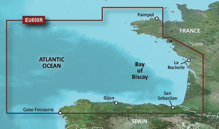
BlueChart g2 - HEU008R - Bay of Biscay v2012.5 (v14.00)
Wed Aug 22, 2012 9:26 pm
BlueChart g2 - HEU008R - Bay of Biscay v2012.5 (v14.00)
info
thanks to pietu
--- supplement by mod ---
Please keep this offer thread clear and ask your questions to bluechart maps >>>here
info
- Code:
https://buy.garmin.com/shop/shop.do?pID=34767
- Code:
[url=http://www11.zippyshare.com/v/36867131/file.html]HXEU008R-L.rar[/url]
thanks to pietu
--- supplement by mod ---
Please keep this offer thread clear and ask your questions to bluechart maps >>>here
Thu Aug 23, 2012 3:42 pm
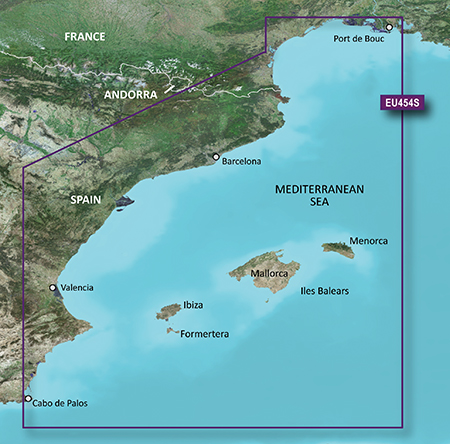
Bluechart G2 - HEU454S - Barcelona & Valencia 2012.5 v.14.00
info
--- supplement by mod ---
Please keep this offer thread clear and ask your questions to bluechart maps >>>here
info
- Code:
https://buy.garmin.com/shop/shop.do?pID=9206&pvID=10822
- Code:
[url]https://www.box.com/s/0e7e68d2b586d8c7f7b7[/url]
--- supplement by mod ---
Please keep this offer thread clear and ask your questions to bluechart maps >>>here
Thu Aug 23, 2012 10:43 pm
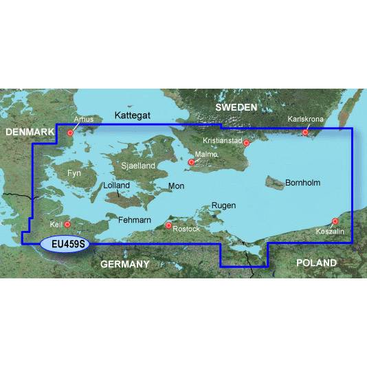
Garmin Bluechart G2 - Hxeu459s - Arhus - Kiel - Koszalin
Features
Coverage
Swedish coast: from Hoganas to Karlskrona, including Malmö. Danish, German, and Polish coasts: from Århus to Koszalin, including Sjælland, Fyn, Møn, Falster, Lolland, Langeland and Fehmarn.
About BlueChart g2 Maps
Get a new perspective on navigation with BlueChart g2 marine cartography. This newly designed map data provides even more detail, dimension and graphical sophistication to a well-proven benchmark of marine navigation.
Featuring crisp labeling and an overall smoother presentation on your chartplotter display, the new generation of BlueChart g2 has numerous improvements to assist in marine navigation. In addition to the basic charts, tidal stations, currents, depth contours, IALA symbols, and included fishing charts, BlueChart g2 offers improved transitioning between zoom levels and more seamless continuity across chart boundaries.
BlueChart g2 also adds Safety Depth settings to let users select up to five values for specific depth contour intervals. And the fishing charts are designed to emphasize bathymetric contours with less visual clutter on the display. There’s also a choice of standard 2D direct overhead or 3D “over the bow” map perspective views to make chart reading and orientation easier.
Realistic navigation features showing everything from shaded depth contours and coastlines to spot soundings, navaids, port plans, wrecks, obstructions, intertidal zones, restricted areas, IALA symbols and more
Smooth display presentation including seamless transitioning between zoom levels and more continuity across chart boundaries
Safety Depth settings lets you select up to five values for specific depth contour intervals
Fishing charts to focus on bathymetric contours with less clutter on the display
Choice of standard 2D direct overhead or 3D “over the bow” map perspective to make chart reading and orientation easier
--- supplement by mod ---
Please keep this offer thread clear and ask your questions to bluechart maps >>>here
Features
Coverage
Swedish coast: from Hoganas to Karlskrona, including Malmö. Danish, German, and Polish coasts: from Århus to Koszalin, including Sjælland, Fyn, Møn, Falster, Lolland, Langeland and Fehmarn.
About BlueChart g2 Maps
Get a new perspective on navigation with BlueChart g2 marine cartography. This newly designed map data provides even more detail, dimension and graphical sophistication to a well-proven benchmark of marine navigation.
Featuring crisp labeling and an overall smoother presentation on your chartplotter display, the new generation of BlueChart g2 has numerous improvements to assist in marine navigation. In addition to the basic charts, tidal stations, currents, depth contours, IALA symbols, and included fishing charts, BlueChart g2 offers improved transitioning between zoom levels and more seamless continuity across chart boundaries.
BlueChart g2 also adds Safety Depth settings to let users select up to five values for specific depth contour intervals. And the fishing charts are designed to emphasize bathymetric contours with less visual clutter on the display. There’s also a choice of standard 2D direct overhead or 3D “over the bow” map perspective views to make chart reading and orientation easier.
Realistic navigation features showing everything from shaded depth contours and coastlines to spot soundings, navaids, port plans, wrecks, obstructions, intertidal zones, restricted areas, IALA symbols and more
Smooth display presentation including seamless transitioning between zoom levels and more continuity across chart boundaries
Safety Depth settings lets you select up to five values for specific depth contour intervals
Fishing charts to focus on bathymetric contours with less clutter on the display
Choice of standard 2D direct overhead or 3D “over the bow” map perspective to make chart reading and orientation easier
- Code:
[url=http://www40.zippyshare.com/v/19492948/file.html]HXEU459S-L.rar[/url]
[url=http://www40.zippyshare.com/v/91501792/file.html]HXEU459S-UL.rar[/url]
- Code:
File:      HXEU459S.img, length 55648256
Header:      10.07.2012 09:10:50, DSKIMG, XOR 00, V 14.00, Ms 0
Mapset:      HXEU459S-Arhus-Kiel-Koszalin v2012.5
fat:      1000h - 1200h - 17800h, block 2048
maps:      28, sub-files 81

Sub-file         fat     length
 MARINAS  MDR   1200h      9490
 MARINAS  SRT   1400h       968
 B0000013 RGN   1600h      1053
 B0000013 LBL   1800h       683
   CP 1252, Western European
 B0000013 TRE   1A00h       571
   map 10d8d44 (17665348)
   PID 1, FID 2646, region 5,10
   date 03.07.2012 14:00:31
   priority 28, parameters 0 6 29 3, transparent
   levels [10,11,12,13,14,15,16,17], zoom [87,6,5,4,3,2,1,0]
   N: 56.337891, S: 53.399048, W: 9.107666, E: 16.715698
   GARMIN G-Map
   Copyright 1995-2012 by GARMIN Corporation.
--- supplement by mod ---
Please keep this offer thread clear and ask your questions to bluechart maps >>>here