Forum
Forum
Part Number: MicroSD/SD (010-C1023-20), Download (010-D0596-00)
See your vessel’s precise, on-chart position in relation to navaids, coastal features, anchorages, obstructions, waterways, restricted areas and more with this detailed marine mapping data.
- Shaded depth contours, coastlines, spot soundings, navaids, port plans, wrecks, obstructions, intertidal zones, restricted areas and IALA symbols.
- Seamless transitions between zoom levels and more continuity across chart boundaries.
- Standard 2-D direct overhead or 3-D “over the bow” map perspective for easy chart reading and orientation.
- Safety Shading* enables contour shading for all depth contours shallower than your defined safe depths.
- Fishing Charts* to scope out bottom contours and depth soundings with less visual clutter on the display.
- Plan and organize routes from your computer with HomePort™ (sold separately).
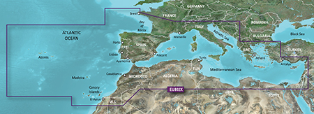
Detailed offshore coastal coverage of the Mediterranean Sea and the Iberian Peninsula in their entireties. Coverage features the Strait of Gibraltar, the Balearic Islands, the French Riviera, Corsica, Sardinia, Sicily, the Adriatic Sea, the Greek Islands, the Aegean Sea, the Dardanelles and Bosporus Straits, the Sea of Marmara, Cyprus, the Suez Canal, Tripoli and Algiers Harbors, and the Gulfs of Gabès and Tunisia. Also details the Atlantic side of the Iberian Peninsula from the Canary Islands to the Bay of Biscay including the Gulf of Cadiz, the Portugal coast in full, the Gulf of Gascogne, and the Madeira and Azores Islands.
FID: 3649, PID: 1, RID: 18, VID: 3
Locked Image:
UnLocked Image:
- Code: Select all
https://buy.garmin.com/en-US/US/maps/on-the-water-maps/bluechart-g2-interactive-maps/heu802x-mediterranean-sea-and-iberian-peninsula/prod72800.html