Forum
Forum
Part Number: GarminCard (010-C0853-10), MicroSD/SD (010-C0853-20), Download (010-D0585-00)
See your vessel’s precise, on-chart position in relation to navaids, coastal features, anchorages, obstructions, waterways, restricted areas and more with this detailed marine mapping data.
- Shaded depth contours, coastlines, spot soundings, navaids, port plans, wrecks, obstructions, intertidal zones, restricted areas and IALA symbols.
- Seamless transitions between zoom levels and more continuity across chart boundaries.
- Standard 2-D direct overhead or 3-D “over the bow” map perspective for easy chart reading and orientation.
- Safety Shading* enables contour shading for all depth contours shallower than your defined safe depths.
- Fishing Charts* to scope out bottom contours and depth soundings with less visual clutter on the display.
- Plan and organize routes from your computer with HomePort™ (sold separately).
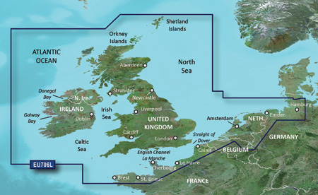
Detailed coverage of the British Isles in their entirety, including the Thames Estuary, Caledonian Canal, Outer Hebrides, Shetland and Orkney Islands, Isle of Wight, Isle of Man, Lough Neagh and the Irish Sea. Continental coverage from Brest, FR to Kiel, DE including the Channel Islands, the Waddenzee, the IJsselmeer, the canals of The Netherlands, the Meuse River to Liege, BE; the Rhine River to Dusseldorf, DE and the Kiel Canal. Detailed coverage of ports include London and Liverpool, UK; Antwerp, BE; Rotterdam and Amsterdam, NE; Calais, FR and Hamburg, DE.
FID: 3257, PID: 1, RID: 4, VID: 12
Locked Image:
UnLocked Image:
- Code: Select all
https://buy.garmin.com/en-US/US/maps/on-the-water-maps/bluechart-g2-interactive-maps/heu706l-uk-ireland-the-netherlands/prod34923.html