BlueChart g2 - HEU505S - Baltic Sea, East Coast 2014.0 (15.50)
Tue May 06, 2014 9:16 am
BlueChart g2 - HEU505S - Baltic Sea, East Coast 2014.0 (15.50)
See your vessel’s precise, on-chart position in relation to navaids, coastal features, anchorages, obstructions, waterways, restricted areas and more with this detailed marine mapping data.
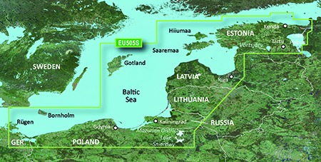
Coverage of the coasts of Germany, Poland, Russia, Lithuania, Latvia and Estonia from Rügen, DE to Narva-Jõesuu, EE. Detailed coverage includes the Szczecin Lagoon, Bornholm, the Vistula Lagoon, Kaliningrad, Gotland, the Gulf of Riga, Saaremaa, Hiiumaa, Lake Peipus, and the Mazurian and other Polish lakes including Lake Jeziorak, Lake Lanskie and Lake Sniardwy.
FID: 3255, PID: 1, RID: 5, VID: 16
Locked Image:
UnLocked Image:
See your vessel’s precise, on-chart position in relation to navaids, coastal features, anchorages, obstructions, waterways, restricted areas and more with this detailed marine mapping data.
- Shaded depth contours, coastlines, spot soundings, navaids, port plans, wrecks, obstructions, intertidal zones, restricted areas and IALA symbols.
- Seamless transitions between zoom levels and more continuity across chart boundaries.
- Standard 2-D direct overhead or 3-D “over the bow” map perspective for easy chart reading and orientation.
- Safety Shading* enables contour shading for all depth contours shallower than your defined safe depths.
- Fishing Charts* to scope out bottom contours and depth soundings with less visual clutter on the display.
- Plan and organize routes from your computer with HomePort™ (sold separately).
Coverage of the coasts of Germany, Poland, Russia, Lithuania, Latvia and Estonia from Rügen, DE to Narva-Jõesuu, EE. Detailed coverage includes the Szczecin Lagoon, Bornholm, the Vistula Lagoon, Kaliningrad, Gotland, the Gulf of Riga, Saaremaa, Hiiumaa, Lake Peipus, and the Mazurian and other Polish lakes including Lake Jeziorak, Lake Lanskie and Lake Sniardwy.
FID: 3255, PID: 1, RID: 5, VID: 16
Locked Image:
UnLocked Image:
- Code:
https://buy.garmin.com/en-US/digital/maps/on-the-water-maps/bluechart-g2-interactive-maps/heu505s-baltic-sea-east-coast/prod34915.html
Re: BlueChart g2 - HEU505S - Baltic Sea, East Coast 2014.0 (15.50)
Wed May 07, 2014 11:00 pm
Re: BlueChart g2 - HEU505S - Baltic Sea, East Coast 2014.0 (
Tue Nov 08, 2022 9:43 am
Can anyone reupload those?
Re: BlueChart g2 - HEU505S - Baltic Sea, East Coast 2014.0 (
Wed Sep 10, 2025 8:08 pm
Can somebody re-upload them please ?
Appreciated in advance
Appreciated in advance