BlueChart g2 - HEU060R - Germany Inland Waters 2015.5 (17.00)
Sun Mar 20, 2016 5:59 am
BlueChart g2 - HEU060R - Germany Inland Waters 2015.5 (17.00)
See your vessel’s precise, on-chart position in relation to navaids, coastal features, anchorages, obstructions, waterways, restricted areas and more with this detailed marine mapping data.
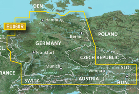
Detailed coverage of the German North Sea and Baltic coast, and the German inland waterway system, including the entirety of the Rhine River, the Main River to Bamberg, the Danube River from Kelheim to Passau in Germany, the Saar River, the Moselle River to Metz, France; the Ems River, the Weser River, the Elbe River to Dresden, the Havel River, the entirety of the Rhine-Main-Danube Canal, the Oder-Havel Canal, the Elbe-Havel Canal, the Elbe-Seiten Canal, the Müritz, the Kiel Canal, the Mittelland Canal, Lake Constance, Lake Zurich and surrounding lakes in Switzerland, lakes in southern Bavaria and Austria including the Chiemsee, Attersee, Neusiedler See and Lake Balaton in Hungary.
FID: 3840, PID: 1, RID: 17, VID: 4
Locked Image:
UnLocked Image:
See your vessel’s precise, on-chart position in relation to navaids, coastal features, anchorages, obstructions, waterways, restricted areas and more with this detailed marine mapping data.
- Shaded depth contours, coastlines, spot soundings, navaids, port plans, wrecks, obstructions, intertidal zones, restricted areas and IALA symbols.
- Seamless transitions between zoom levels and more continuity across chart boundaries.
- Standard 2-D direct overhead or 3-D “over the bow” map perspective for easy chart reading and orientation.
- Safety Shading* enables contour shading for all depth contours shallower than your defined safe depths.
- Fishing Charts* to scope out bottom contours and depth soundings with less visual clutter on the display.
- Plan and organize routes from your computer with HomePort™ (sold separately).
Detailed coverage of the German North Sea and Baltic coast, and the German inland waterway system, including the entirety of the Rhine River, the Main River to Bamberg, the Danube River from Kelheim to Passau in Germany, the Saar River, the Moselle River to Metz, France; the Ems River, the Weser River, the Elbe River to Dresden, the Havel River, the entirety of the Rhine-Main-Danube Canal, the Oder-Havel Canal, the Elbe-Havel Canal, the Elbe-Seiten Canal, the Müritz, the Kiel Canal, the Mittelland Canal, Lake Constance, Lake Zurich and surrounding lakes in Switzerland, lakes in southern Bavaria and Austria including the Chiemsee, Attersee, Neusiedler See and Lake Balaton in Hungary.
FID: 3840, PID: 1, RID: 17, VID: 4
Locked Image:
UnLocked Image:
- Code:
https://buy.garmin.com/en-US/US/prod135174.html
Re: BlueChart g2 - HEU060R - Germany Inland Waters 2015.5 (17.00)
Sun Mar 27, 2016 1:46 pm
Re: BlueChart g2 - HEU060R - Germany Inland Waters 2015.5 (1
Mon Oct 17, 2016 7:57 pm
 thanks!
Re: BlueChart g2 - HEU060R - Germany Inland Waters 2015.5 (1
Sat Jul 09, 2022 8:20 am
hey !
Can anyone upload a new one please ? Unlock if possible
Can anyone upload a new one please ? Unlock if possible
Re: BlueChart g2 - HEU060R - Germany Inland Waters 2015.5 (1
Sat Jul 09, 2022 5:15 pm
Re-uploaded
- Hidden Content
- This board requires you to be registered and logged-in to view hidden content.
Re: BlueChart g2 - HEU060R - Germany Inland Waters 2015.5 (1
Sat Jun 22, 2024 9:46 am
hey !
Can anyone upload a new one please ? Unlock if possible
Can anyone upload a new one please ? Unlock if possible