BlueChart g2 - HEU050R - Gulfs of Finland & Riga 2014.0 (15.50)
Fri Jun 06, 2014 2:01 pm
BlueChart g2 - HEU050R - Gulfs of Finland & Riga 2014.0 (15.50)
See your vessel’s precise, on-chart position in relation to navaids, coastal features, anchorages, obstructions, waterways, restricted areas and more with this detailed marine mapping data.
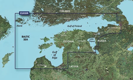
Detailed coverage of the Gulf of Finland from Åland to and including St. Petersburg, RU.; the Gulf of Riga and the northern half of Lake Preipus. Includes detailed coverage of the cities of Turku, Helsinki, and Kotka, FI; Vyborg, Kronshtadt and Lomonosov, RU; Tallinn, Estonia; Riga and Ventspils in Latvia.
FID: 3256, PID: 1, RID: 2, VID: 53
Locked Image:
UnLocked Image:
See your vessel’s precise, on-chart position in relation to navaids, coastal features, anchorages, obstructions, waterways, restricted areas and more with this detailed marine mapping data.
- Shaded depth contours, coastlines, spot soundings, navaids, port plans, wrecks, obstructions, intertidal zones, restricted areas and IALA symbols.
- Seamless transitions between zoom levels and more continuity across chart boundaries.
- Standard 2-D direct overhead or 3-D “over the bow” map perspective for easy chart reading and orientation.
- Safety Shading* enables contour shading for all depth contours shallower than your defined safe depths.
- Fishing Charts* to scope out bottom contours and depth soundings with less visual clutter on the display.
- Plan and organize routes from your computer with HomePort™ (sold separately).
Detailed coverage of the Gulf of Finland from Åland to and including St. Petersburg, RU.; the Gulf of Riga and the northern half of Lake Preipus. Includes detailed coverage of the cities of Turku, Helsinki, and Kotka, FI; Vyborg, Kronshtadt and Lomonosov, RU; Tallinn, Estonia; Riga and Ventspils in Latvia.
FID: 3256, PID: 1, RID: 2, VID: 53
Locked Image:
UnLocked Image:
- Code:
https://buy.garmin.com/en-US/digital/maps/on-the-water-maps/bluechart-g2-interactive-maps/heu050r-gulfs-of-finland-riga/prod34805.html
Re: BlueChart g2 - HEU050R - Gulfs of Finland & Riga 2014.0 (15.50)
Sat Jun 07, 2014 6:14 am