BlueChart g2 - HEU018R - The Netherlands 2014.0 (15.50)   

BlueChart g2 - HEU018R - The Netherlands 2014.0 (15.50)

Postby huntsman » Wed Aug 27, 2014 9:50 pm

BlueChart g2 - HEU018R - The Netherlands 2014.0 (15.50) => (HEU018R-Benelux Offshore & Inland Waters)

See your vessel’s precise, on-chart position in relation to navaids, coastal features, anchorages, obstructions, waterways, restricted areas and more with this detailed marine mapping data.
  • Shaded depth contours, coastlines, spot soundings, navaids, port plans, wrecks, obstructions, intertidal zones, restricted areas and IALA symbols.
  • Seamless transitions between zoom levels and more continuity across chart boundaries.
  • Standard 2-D direct overhead or 3-D “over the bow” map perspective for easy chart reading and orientation.
  • Safety Shading* enables contour shading for all depth contours shallower than your defined safe depths.
  • Fishing Charts* to scope out bottom contours and depth soundings with less visual clutter on the display.
  • Plan and organize routes from your computer with HomePort™ (sold separately).
Coverage
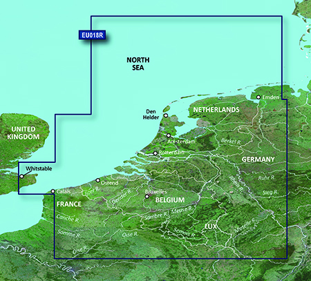
Continental coverage: from Spiekeroog, Germany to Calais, France, including The Netherlands and Belgium coast entirely. Great Britain coverage: from Whitstable to Folkestone.

FID: 3256, PID: 1, RID: 2, VID: 24

Locked Image:
[Please Register or Login to download file]


UnLocked Image:
[Please Register or Login to download file]

Code: Select all
https://buy.garmin.com/en-US/US/maps/prod34785.html

Image
huntsman offline


User avatar Elite Member


Joined: Fri Sep 17, 2010 8:58 pm
Posts: 970
Has thanked: 2 times
Been thanked: 1295 times

Re: BlueChart g2 - HEU018R - The Netherlands 2014.0 (15.50)

Postby bam-bam » Tue Sep 09, 2014 1:54 pm

unl.img

This board requires you to be registered and logged-in to view hidden content.
bam-bam offline


User avatar Ex Moderator


Joined: Fri Jul 23, 2010 9:43 pm
Posts: 1420
Location: .BG
Has thanked: 51 times
Been thanked: 2004 times
Age: 44

Re: BlueChart g2 - HEU018R - The Netherlands 2014.0 (15.50)

Postby jdemanager » Tue Aug 25, 2015 5:39 am

Links seem to be dead. Can someone please reupload. Thanks!
jdemanager offline


Junior Member


Joined: Thu Jun 09, 2011 1:03 am
Posts: 2
Has thanked: 0 time
Been thanked: 0 time

Re: BlueChart g2 - HEU018R - The Netherlands 2014.0 (15.50)

Postby sooty666 » Tue Sep 29, 2015 4:30 pm

Is this file still available??
sooty666 offline


Junior Member


Joined: Tue Sep 29, 2015 4:24 pm
Posts: 1
Has thanked: 0 time
Been thanked: 0 time

Re: BlueChart g2 - HEU018R - The Netherlands 2014.0 (15.50)

Postby irinavalex » Wed Dec 23, 2015 6:25 pm

Can someone reupload it? Please!
irinavalex offline


Junior Member


Joined: Wed Dec 23, 2015 5:51 pm
Posts: 1
Has thanked: 0 time
Been thanked: 0 time

Re: BlueChart g2 - HEU018R - The Netherlands 2014.0 (15.50)

Postby thetester1 » Sat Jan 16, 2016 1:06 pm

magnet:?xt=urn:btih:1D9C55ADECEFE7ABF582140A5D9144FD09E3C388
thetester1 offline


Junior Member


Joined: Sat Jan 16, 2016 12:15 pm
Posts: 1
Has thanked: 3 times
Been thanked: 0 time


Return to New Maps


  • Related topics
    Replies
    Views
    Last post

Who is online

Users browsing this forum: comitato, martintwo, trabs and 10 guests