BlueChart g2 - HAF001R - Eastern Africa 2014.5 (16.00)
Sun Mar 22, 2015 10:25 pm
BlueChart g2 - HAF001R - Eastern Africa 2014.5 (16.00)
See your vessel’s precise, on-chart position in relation to navaids, coastal features, anchorages, obstructions, waterways, restricted areas and more with this detailed marine mapping data.
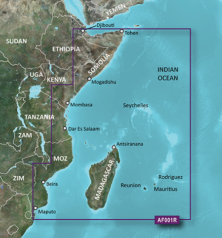
General coverage of the east coast of Africa from the Gulf of Tadjoura to the Bay of Maputo, including Mogadishu, Som., Mombasa, Ken., and Dar es Salaam, Tan. Also includes general coverage of the entire coast of Madagascar. Includes detailed coverage of Djibouti, Dji., Maputo, Moz., Mauritius, Reunion, and the Seychelles.
FID: 3490, PID: 1, RID: 2, VID: 1
Locked Image:
UnLocked Image:
See your vessel’s precise, on-chart position in relation to navaids, coastal features, anchorages, obstructions, waterways, restricted areas and more with this detailed marine mapping data.
- Shaded depth contours, coastlines, spot soundings, navaids, port plans, wrecks, obstructions, intertidal zones, restricted areas and IALA symbols.
- Seamless transitions between zoom levels and more continuity across chart boundaries.
- Standard 2-D direct overhead or 3-D “over the bow” map perspective for easy chart reading and orientation.
- Safety Shading* enables contour shading for all depth contours shallower than your defined safe depths.
- Fishing Charts* to scope out bottom contours and depth soundings with less visual clutter on the display.
- Plan and organize routes from your computer with HomePort™.
General coverage of the east coast of Africa from the Gulf of Tadjoura to the Bay of Maputo, including Mogadishu, Som., Mombasa, Ken., and Dar es Salaam, Tan. Also includes general coverage of the entire coast of Madagascar. Includes detailed coverage of Djibouti, Dji., Maputo, Moz., Mauritius, Reunion, and the Seychelles.
FID: 3490, PID: 1, RID: 2, VID: 1
Locked Image:
UnLocked Image:
- Code:
https://buy.garmin.com/en-US/US/maps/prod33837.html
Re: BlueChart g2 - HAF001R - Eastern Africa 2014.5 (16.00)
Wed Mar 25, 2015 4:34 pm
Re: BlueChart g2 - HAF001R - Eastern Africa 2014.5 (16.00)
Thu Sep 10, 2015 9:17 pm
Please, can you re-link, don't work... Please.
Re: BlueChart g2 - HAF001R - Eastern Africa 2014.5 (16.00)
Mon Mar 07, 2016 2:21 pm
Hi,
Can you please relink this map?
Thanks in advance
Can you please relink this map?
Thanks in advance