Various .dem files (Digital Elevation Maps) for iGO/Primo
Mon Aug 26, 2013 4:30 pm
List of available .dem files (Digital Elevation Maps) for iGO/Primo:
Africa (CGIAR+NASA)
Argentina (CGIAR) [premium]
Australia (CGIAR)
Brazil (CGIAR) [premium]
Brazil (NASA)
British Islands (UK and Ireland) (Teleatlas)
Canada (CGIAR)
China (CGIAR)
Colombia (CGIAR)
Costa Rica (CGIAR)
Eurasia (CGIAR+NASA)
Europe (CGIAR) [Full + Premium]
Europe (NASA)
Europe (TeleAtlas)
Eastern Europe & Western Europe (CGIAR) [Premium]
France (TeleAtlas)
Germany, Austria, Switzerland (inc. Liechtenstein) (TeleAtlas)
India (CGIAR)
Israel (NASA)
Italy (TeleAtlas)
Mexico (CGIAR) [Full+Premium]
Middle East and Africa (NASA)
New Zealand (CGIAR)
Oceania (CGIAR+NASA)
Russia (CGIAR) [Premium]
Russia Eastern (CGIAR) [Full+Premium]
Russia Eastern (NASA)
Russia North (CGIAR) [Full+Premium]
Russia North (NASA)
Russia West (NASA+CGIAR)
South America (CGIAR+NASA)
South East Asia (CGIAR)
Taiwan (CGIAR)
USA (CGIAR) [Premium]
North America (NASA)
North America (CGIAR+NASA) [Basic]
Press reload or refresh after pressing thanks.
password for all files: www.navitotal.com
Found dead links? read ->>HERE<<-
Africa (CGIAR+NASA)
- Hidden Content
- This board requires you to be registered and logged-in to view hidden content.
Argentina (CGIAR) [premium]
- Hidden Content
- This board requires you to be registered and logged-in to view hidden content.
Australia (CGIAR)
- Hidden Content
- This board requires you to be registered and logged-in to view hidden content.
Brazil (CGIAR) [premium]
- Hidden Content
- This board requires you to be registered and logged-in to view hidden content.
Brazil (NASA)
- Hidden Content
- This board requires you to be registered and logged-in to view hidden content.
British Islands (UK and Ireland) (Teleatlas)
- Hidden Content
- This board requires you to be registered and logged-in to view hidden content.
Canada (CGIAR)
- Hidden Content
- This board requires you to be registered and logged-in to view hidden content.
China (CGIAR)
- Hidden Content
- This board requires you to be registered and logged-in to view hidden content.
Colombia (CGIAR)
- Hidden Content
- This board requires you to be registered and logged-in to view hidden content.
Costa Rica (CGIAR)
- Hidden Content
- This board requires you to be registered and logged-in to view hidden content.
Eurasia (CGIAR+NASA)
- Hidden Content
- This board requires you to be registered and logged-in to view hidden content.
Europe (CGIAR) [Full + Premium]
- Hidden Content
- This board requires you to be registered and logged-in to view hidden content.
Europe (NASA)
- Hidden Content
- This board requires you to be registered and logged-in to view hidden content.
Europe (TeleAtlas)
- Hidden Content
- This board requires you to be registered and logged-in to view hidden content.
Eastern Europe & Western Europe (CGIAR) [Premium]
- Hidden Content
- This board requires you to be registered and logged-in to view hidden content.
France (TeleAtlas)
- Hidden Content
- This board requires you to be registered and logged-in to view hidden content.
Germany, Austria, Switzerland (inc. Liechtenstein) (TeleAtlas)
- Hidden Content
- This board requires you to be registered and logged-in to view hidden content.
India (CGIAR)
- Hidden Content
- This board requires you to be registered and logged-in to view hidden content.
Israel (NASA)
- Hidden Content
- This board requires you to be registered and logged-in to view hidden content.
Italy (TeleAtlas)
- Hidden Content
- This board requires you to be registered and logged-in to view hidden content.
Mexico (CGIAR) [Full+Premium]
- Hidden Content
- This board requires you to be registered and logged-in to view hidden content.
Middle East and Africa (NASA)
- Hidden Content
- This board requires you to be registered and logged-in to view hidden content.
New Zealand (CGIAR)
- Hidden Content
- This board requires you to be registered and logged-in to view hidden content.
Oceania (CGIAR+NASA)
- Hidden Content
- This board requires you to be registered and logged-in to view hidden content.
Russia (CGIAR) [Premium]
- Hidden Content
- This board requires you to be registered and logged-in to view hidden content.
Russia Eastern (CGIAR) [Full+Premium]
- Hidden Content
- This board requires you to be registered and logged-in to view hidden content.
Russia Eastern (NASA)
- Hidden Content
- This board requires you to be registered and logged-in to view hidden content.
Russia North (CGIAR) [Full+Premium]
- Hidden Content
- This board requires you to be registered and logged-in to view hidden content.
Russia North (NASA)
- Hidden Content
- This board requires you to be registered and logged-in to view hidden content.
Russia West (NASA+CGIAR)
- Hidden Content
- This board requires you to be registered and logged-in to view hidden content.
South America (CGIAR+NASA)
- Hidden Content
- This board requires you to be registered and logged-in to view hidden content.
South East Asia (CGIAR)
- Hidden Content
- This board requires you to be registered and logged-in to view hidden content.
Taiwan (CGIAR)
- Hidden Content
- This board requires you to be registered and logged-in to view hidden content.
USA (CGIAR) [Premium]
- Hidden Content
- This board requires you to be registered and logged-in to view hidden content.
North America (NASA)
- Hidden Content
- This board requires you to be registered and logged-in to view hidden content.
North America (CGIAR+NASA) [Basic]
- Hidden Content
- This board requires you to be registered and logged-in to view hidden content.
Press reload or refresh after pressing thanks.
password for all files: www.navitotal.com
Found dead links? read ->>HERE<<-
Re: Various .dem files (Digital Elevation Maps) for iGO/Primo
Thu Oct 09, 2014 1:07 pm
I just want everyone to know that .dem files have been known to cause error memory messages on some devices. They are only eye-candy and nothing for navigation. So unless you MUST have them I would leave them off my device. Just a friendly warning. 
Re: Various .dem files (Digital Elevation Maps) for iGO/Primo
Thu Oct 09, 2014 6:17 pm
Please download what you need from [Please Register or Login to download file] . <-- Look here
Last edited by filesupload100 on Fri Dec 12, 2014 11:19 am, edited 2 times in total.
Re: Various .dem files (Digital Elevation Maps) for iGO/Primo
Mon Oct 13, 2014 9:04 am
Hi, which is better fo europe?
Re: Various .dem files (Digital Elevation Maps) for iGO/Primo
Mon Oct 13, 2014 10:09 am
No idea really.
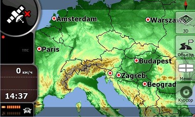
DEM is a DEMographic file which shows the landscape (hills, lakes, etc) and is not needed for routing, it's just eye candy.
Consider that DEM eats lots of memory, so for the - esp memory low - device a smaller file is better. I suppose (!!!) a bigger file might show more detail. Or not? I never looked that close to see if the shape on the screen matches the reality.
Re: Various .dem files (Digital Elevation Maps) for iGO/Primo
Fri Jan 02, 2015 10:06 pm
nabi wrote:No idea really.
DEM is a DEMographic file which shows the landscape (hills, lakes, etc) and is not needed for routing, it's just eye candy.
Consider that DEM eats lots of memory, so for the - esp memory low - device a smaller file is better. I suppose (!!!) a bigger file might show more detail. Or not? I never looked that close to see if the shape on the screen matches the reality.
It's not eye-candy in my opinion, when you drive late night on a hilly terrain. I use both a C310 Mio (very very old model, probably from 2006) and an Android. Of course,the Android can handle everything, and on the mio: it works absolutely fine. It doesn't take longer at all to refresh. The refresh rate is the exact same. Very well worth it, I don't see any cons to upload them onto your device.


Re: Various .dem files (Digital Elevation Maps) for iGO/Primo
Fri Jan 02, 2015 10:53 pm
gipfeli wrote:nabi wrote:No idea really.
DEM is a DEMographic file which shows the landscape (hills, lakes, etc) and is not needed for routing, it's just eye candy.
Consider that DEM eats lots of memory, so for the - esp memory low - device a smaller file is better. I suppose (!!!) a bigger file might show more detail. Or not? I never looked that close to see if the shape on the screen matches the reality.
It's not eye-candy in my opinion, when you drive late night in a hilly terrain. I use both a C310 Mio (very very old model, probably from 2006) and an Android. Of course,the Android can handle everything, and on the mio: it works absolutely fine. It doesn't take longer at all to refresh. The refresh rate is the exact same. Very well worth it, I don't see any cons to upload them onto your device.
Sorry but I have to disagree with your assessment about no cons regarding dems. I have been a GPS mod for many years and I can't tell you how many times members have had memory problems with their devices because of the dem files. Dem files ARE just eye-candy and don't do anything regarding navigation. However they demand and use a high memory and can cause the previously mentioned error messages. Count yourself very lucky that your device has the necessary memory because many devices don't.

Re: Various .dem files (Digital Elevation Maps) for iGO/Primo
Sat Jan 03, 2015 6:53 am
chas521 wrote:Sorry but I have to disagree with your assessment about no cons regarding dems. I have been a GPS mod for many years and I can't tell you how many times members have had memory problems with their devices because of the dem files. Dem files ARE just eye-candy and don't do anything regarding navigation. However they demand and use a high memory and can cause the previously mentioned error messages. Count yourself very lucky that your device has the necessary memory because many devices don't.
I'm pretty sure you know a lot more about other devices, because I only exclusively modded 4 Mio devices. I prayed really hard that the C310 model would be able to process the .dem file, but then it worked. I've never had a single crash whatsoever, even when running straight from a ghetto SD card. It's hard to believe that so many people have problems, because my assumption was that most people on here have newer and more powerful devices (than my oldest GPS device) that are able to handle the processing and rendering.
However, I say, still try it, if you live in Colorado/Utah/Wyoming. Even though it doesn't contribute to the navigation itself, it is an immense help when driving at night. There is a difference when it allows you to anticipate a blind left/right turn in the mountains as opposed to a flat 2D turn.
The true eye candy, if you ask me, is the building file

Re: Various .dem files (Digital Elevation Maps) for iGO/Primo
Sun Jan 11, 2015 4:59 pm
Digital Elevation Maps (DEM files)
http://gpsarab.com/shop11/en/content/40-digital-elevation-maps-dem-files
http://gpsarab.com/shop11/en/content/40-digital-elevation-maps-dem-files
Re: Various .dem files (Digital Elevation Maps) for iGO/Prim
Tue Jul 12, 2016 9:03 pm
BRAZIL NASA DEM link its of , can you fix it please ?
Re: Various .dem files (Digital Elevation Maps) for iGO/Prim
Wed Jul 13, 2016 5:55 pm
Re: Various .dem files (Digital Elevation Maps) for iGO/Prim
Wed Jul 13, 2016 6:48 pm
claudiogalvao10 wrote:BRAZIL NASA DEM link its of , can you fix it please ?
Torrent
- Hidden Content
- This board requires you to be registered and logged-in to view hidden content.
link
- Hidden Content
- This board requires you to be registered and logged-in to view hidden content.
pw:nyky
Re: Various .dem files (Digital Elevation Maps) for iGO/Prim
Wed Jul 13, 2016 7:27 pm
Personally, I love having the DEM files - and I usually install the biggest DEM file I can find (seriously) - it just enhances the look of the display so much. Yes, it's just "eye candy", but in my opinion, presentation is important to the overall "enjoyability" of a navigation unit. Yes, it works without it. It's kind of like TV - HD isn't required to watch TV, but it sure makes it more enjoyable to watch. :-)
I use a 300MB DEM file on my 128mb WinCE device. But I've also used a DEM file on my old Mio Moov 200 and it worked flawlessly. I think that most modern devices can handle DEM files just fine. Maybe it was more of a problem "back in the day"... But it can't hurt to try it - if it causes problem, then remove it. Pretty simple really...
Just my 2 cents...
Sent from my HP SlateBook 10 x2 PC using Tapatalk
Re: Various .dem files (Digital Elevation Maps) for iGO/Prim
Wed Jul 13, 2016 8:50 pm
Isn't your reaction a year over time?
Re: Various .dem files (Digital Elevation Maps) for iGO/Prim
Wed Jul 13, 2016 8:58 pm
Ha! DIdn't even notice the posts were that old! :-) Better late than never, I guess! :-)
Sent from my HP SlateBook 10 x2 PC using Tapatalk
Sent from my HP SlateBook 10 x2 PC using Tapatalk