City Navigator West Africa NT 2015.30   

City Navigator West Africa NT 2015.30

Postby huntsman » Mon Dec 22, 2014 8:15 pm

City Navigator West Africa NT 2015.30

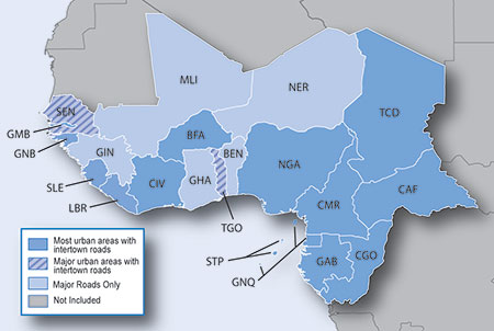
Navigate the streets with confidence. This product provides detailed road maps and points of interest for your device, so you can navigate with exact, turn-by-turn directions to any address or intersection.

Features motorways, national and regional thoroughfares and local roads, in Western Africa, specifically:

  • Nigeria
  • Benin
  • Togo
  • Ghana
  • Ivory Coast
  • Guinea
  • Gambia
  • Senegal
  • Burkina Faso
  • Mali
  • Niger
FID: 3474, PID: 1, RID: 1, VID: 2

Image:
Locked: [Please Register or Login to download file] | [Please Register or Login to download file]
or [Please Register or Login to download file] | [Please Register or Login to download file]

UnLocked: [Please Register or Login to download file] | [Please Register or Login to download file]
or [Please Register or Login to download file] | [Please Register or Login to download file]


POI: Tracks4AfricaWestAfrica_2015_30.gpi
Locked & UnLocked
[Please Register or Login to download file]
or [Please Register or Login to download file]


Image
Code: Select all
https://buy.garmin.com/en-US/US/maps/prod99319.html
huntsman offline


User avatar Elite Member


Joined: Fri Sep 17, 2010 8:58 pm
Posts: 970
Has thanked: 2 times
Been thanked: 1295 times

Re: City Navigator West Africa NT 2015.30

Postby [DaY]BooM » Tue Dec 23, 2014 8:41 am

City Navigator West Africa NT 2015.30


Code: Select all
[*] Includes more than 597,000 mi (960,000 km) of roads, including motorways, national and regional thoroughfares and local roads, in Western Africa
[*]    Displays thousands of points of interest throughout the continent, including restaurants, lodging, petrol/gasoline stations, attractions and railways
[*]    Gives turn-by-turn directions on compatible devices
[*]    Speaks street names (example: "Turn right on Main Street")
[*]    Includes navigational features, such as turn restrictions, roundabout guidance and speed categories
[*]    Contains traffic data for compatible devices that use traffic receivers


Code: Select all
File:      gmapprom.img, length 982581248
Header:      29.09.2014 14:01:54, DSKIMG, XOR 00, V 20.15, Ms 0, D413800AG046
Mapset:      CN East & West Africa NT 2015.30 West Africa
fat:      1000h - 1200h - 24000h, block 16384
maps:      60, sub-files 60

Sub-file         fat     length
 I11BF331 GMP   1200h   1577153
   GMP:  TRE RGN LBL NET NOD DEM
   map 11bf331 (18608945)
   PID 1, FID 3474, region 1,2
   date 23.09.2014 14:25:09
   priority 30, parameters 1 3 17 1, locked
   N: 13.825264, S: 13.065276, W: -18.000026, E: -13.792176
   CN East & West Africa NT 2015.30
   Copyright 1995-2014 by GARMIN Corporation.


gmapprom.img
Tracks4AfricaWestAfrica_2015_30.gpi


This board requires you to be registered and logged-in to view hidden content.
SEND ME PRIVATE MESSAGE IF ANY MY LINK IS DEAD.
PreSS ThAnKs BuTToN iF i HelpeD YoU.
[DaY]BooM offline


Junior Member


Joined: Tue Nov 04, 2014 7:22 pm
Posts: 53
Has thanked: 1 time
Been thanked: 337 times

Re: City Navigator West Africa NT 2015.30

Postby bam-bam » Thu Dec 25, 2014 9:02 am

unl.img + gpi

This board requires you to be registered and logged-in to view hidden content.
bam-bam offline


User avatar Ex Moderator


Joined: Fri Jul 23, 2010 9:43 pm
Posts: 1420
Location: .BG
Has thanked: 51 times
Been thanked: 2004 times
Age: 44


Return to New Maps


  • Related topics
    Replies
    Views
    Last post

Who is online

Users browsing this forum: No registered users and 3 guests