BlueChart g2 - HXRU002R - Black Sea & Azov Sea   

BlueChart g2 - HXRU002R - Black Sea & Azov Sea

Postby huntsman » Fri Oct 24, 2014 10:54 am

BlueChart g2 - HXRU002R-Black Sea & Azov Sea

See your vessel’s precise, on-chart position in relation to navaids, coastal features, anchorages, obstructions, waterways, restricted areas and more with this detailed marine mapping data.
  • Shaded depth contours, coastlines, spot soundings, navaids, port plans, wrecks, obstructions, intertidal zones, restricted areas and IALA symbols.
  • Seamless transitions between zoom levels and more continuity across chart boundaries.
  • Standard 2-D direct overhead or 3-D “over the bow” map perspective for easy chart reading and orientation.
  • Safety Shading* enables contour shading for all depth contours shallower than your defined safe depths.
  • Fishing Charts* to scope out bottom contours and depth soundings with less visual clutter on the display.
  • Plan and organize routes from your computer with HomePort™ (sold separately).
Coverage
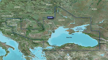
Coverage of the Dardanelles, the Sea of Mamara, the Bosporus, the Black Sea, the Dnieper River as far as Kherson, the Bug River as far as Nikolayev and the Sea of Azov.

Detailed coverage includes Burgas and Varna, Bulgaria; Constanta, Romania; Odessa, Nikolayev, Kherson, Sevastopol', Kerch' and Mariupol, Ukraine; Taganrog, Yeysk, Temryuk, Novorossiysk, Poti and Batumi, Russia; Hopa, Giresun, Samsun, Zonguldak, Eregli, Istanbul, Bandirma and Canakkale, Turkey.

FID: 3840, PID: 1, RID: 17, VID: 3

Locked Image:
[Please Register or Login to download file]


UnLocked Image:
[Please Register or Login to download file]

Code: Select all
https://buy.garmin.com/en-US/US/maps/prod95175.html

Image
Last edited by huntsman on Wed Nov 04, 2015 1:32 pm, edited 3 times in total.
huntsman offline


User avatar Elite Member


Joined: Fri Sep 17, 2010 8:58 pm
Posts: 970
Has thanked: 2 times
Been thanked: 1295 times

Re: BlueChart g2 - HXRU002R-Black Sea & Azov Sea 2014.0 (15.50)

Postby bam-bam » Tue Oct 28, 2014 12:20 pm

unl.img

This board requires you to be registered and logged-in to view hidden content.
bam-bam offline


User avatar Ex Moderator


Joined: Fri Jul 23, 2010 9:43 pm
Posts: 1420
Location: .BG
Has thanked: 51 times
Been thanked: 2003 times
Age: 44

Re: BlueChart g2 - HXRU002R-Black Sea & Azov Sea 2014.0 (15.50)

Postby debeliamark » Wed Nov 04, 2015 5:16 am

Please, upload it again somewhere .. the links are obsolete
debeliamark offline


Junior Member


Joined: Thu Oct 07, 2010 10:06 am
Posts: 56
Has thanked: 59 times
Been thanked: 20 times

Re: BlueChart g2 - HXRU002R - Black Sea & Azov Sea

Postby PyCu4 » Tue Apr 18, 2017 10:25 am

Hi, all link is dead... post new link, please
PyCu4 offline


Junior Member


Joined: Tue Jun 21, 2011 11:32 am
Posts: 3
Has thanked: 0 time
Been thanked: 0 time


Return to New Maps


  • Related topics
    Replies
    Views
    Last post

Who is online

Users browsing this forum: Kostra13 and 7 guests