BlueChart g2 - HEU010R - Mediterranean Sea, Genova-Ayamonte 2014.0 (15.50)   

BlueChart g2 - HEU010R - Mediterranean Sea, Genova-Ayamonte 2014.0 (15.50)

Postby huntsman » Sat Oct 11, 2014 9:26 am

BlueChart g2 - HEU010R - Mediterranean Sea, Genova-Ayamonte 2014.0 (15.50)

See your vessel’s precise, on-chart position in relation to navaids, coastal features, anchorages, obstructions, waterways, restricted areas and more with this detailed marine mapping data.
  • Shaded depth contours, coastlines, spot soundings, navaids, port plans, wrecks, obstructions, intertidal zones, restricted areas and IALA symbols.
  • Seamless transitions between zoom levels and more continuity across chart boundaries.
  • Standard 2-D direct overhead or 3-D “over the bow” map perspective for easy chart reading and orientation.
  • Safety Shading* enables contour shading for all depth contours shallower than your defined safe depths.
  • Fishing Charts* to scope out bottom contours and depth soundings with less visual clutter on the display.
  • Plan and organize routes from your computer with HomePort™ (sold separately).
Coverage
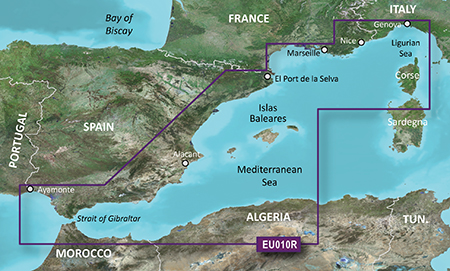
Detailed coverage of the entire Spanish and French Mediterranean coast from the Straight of Gibraltar to La Spezia, IT. Includes coverage of Corse, the northern part of Sardegna, and the Islas Baleares. Also covers the northern coasts of Morocco and Algeria from Larache, MA, to Bejaia, DZ

FID: 3256, PID: 1, RID: 2, VID: 16

Locked Image:
[Please Register or Login to download file]


UnLocked Image:
[Please Register or Login to download file]

Code: Select all
https://buy.garmin.com/en-US/US/maps/prod34771.html

Image
huntsman offline


User avatar Elite Member


Joined: Fri Sep 17, 2010 8:58 pm
Posts: 970
Has thanked: 2 times
Been thanked: 1295 times

Re: BlueChart g2 - HEU010R - Mediterranean Sea, Genova-Ayamonte 2014.0 (15.50)

Postby bam-bam » Fri Oct 24, 2014 1:56 pm

unl.img

This board requires you to be registered and logged-in to view hidden content.
bam-bam offline


User avatar Ex Moderator


Joined: Fri Jul 23, 2010 9:43 pm
Posts: 1420
Location: .BG
Has thanked: 51 times
Been thanked: 2003 times
Age: 44

Re: BlueChart g2 - HEU010R - Mediterranean Sea, Genova-Ayamonte 2014.0 (15.50)

Postby c4rm3l0 » Thu Jan 14, 2016 11:31 am

hi all, this links seems to be broken, pleas can you update them.
thnx
c4rm3l0 offline


Junior Member


Joined: Thu Jan 14, 2016 10:32 am
Posts: 1
Has thanked: 0 time
Been thanked: 0 time

Re: BlueChart g2 - HEU010R - Mediterranean Sea, Genova-Ayamo

Postby derhampa » Mon Dec 26, 2016 12:57 pm

Hello. All links of HEU010R seem broken. Can you post this again, please?
derhampa offline


Junior Member


Joined: Sat Oct 08, 2016 4:46 pm
Posts: 2
Has thanked: 0 time
Been thanked: 0 time

Re: BlueChart g2 - HEU010R - Mediterranean Sea, Genova-Ayamo

Postby raulsueca » Fri Jan 05, 2024 3:01 pm

Good afternoon
Can someone upload the links of garmin bluechart g2 VEU010R?? thank you
raulsueca offline


Junior Member


Joined: Thu Jul 26, 2018 9:31 pm
Posts: 2
Has thanked: 0 time
Been thanked: 0 time


Return to New Maps


  • Related topics
    Replies
    Views
    Last post

Who is online

Users browsing this forum: No registered users and 8 guests