BlueChart g2 - HAE009R - Sin/Mal/Indonesia 2014.0 (15.50)   

BlueChart g2 - HAE009R - Sin/Mal/Indonesia 2014.0 (15.50)

Postby huntsman » Tue Mar 25, 2014 4:36 pm

BlueChart g2 - HAE009R - Sin/Mal/Indonesia 2014.0 (15.50)

See your vessel’s precise, on-chart position in relation to navaids, coastal features, anchorages, obstructions, waterways, restricted areas and more with this detailed marine mapping data.
  • Shaded depth contours, coastlines, spot soundings, navaids, port plans, wrecks, obstructions, intertidal zones, restricted areas and IALA symbols.
  • Seamless transitions between zoom levels and more continuity across chart boundaries.
  • Standard 2-D direct overhead or 3-D “over the bow” map perspective for easy chart reading and orientation.
  • Safety Shading* enables contour shading for all depth contours shallower than your defined safe depths.
  • Fishing Charts* to scope out bottom contours and depth soundings with less visual clutter on the display.
  • Plan and organize routes from your computer with HomePort™ (sold separately).
Coverage
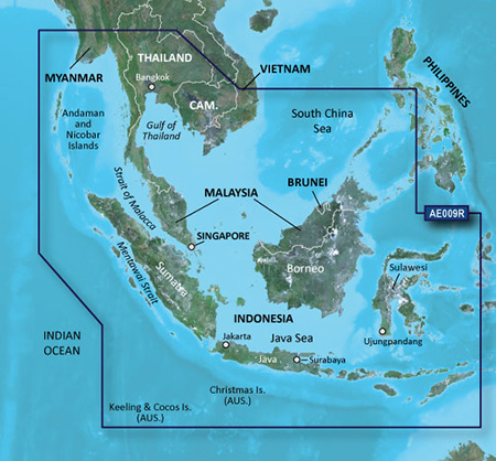
Coverage of the entire Malay Peninsula; Thailand; Cambodia; southern Vietnam including Ho Chi Minh City and the Mekong Delta; Brunei and Indonesia west of Timor. Islands covered include Java, Sumatra, Sulawesi and Borneo, Indonesia; Christmas Islands, Keeling Islands, Cocos Islands and the Andaman and Nicobar Islands.

FID: 3260, PID: 1, RID: 3, VID: 30

Locked Image:
[Please Register or Login to download file] | [Please Register or Login to download file]


UnLocked Image:
[Please Register or Login to download file] | [Please Register or Login to download file]

Code: Select all
https://buy.garmin.com/en-US/US/maps/on-the-water-maps/bluechart-g2-interactive-maps/hae009r-sin-mal-indonesia/prod33638.html

Image
huntsman offline


User avatar Elite Member


Joined: Fri Sep 17, 2010 8:58 pm
Posts: 970
Has thanked: 2 times
Been thanked: 1295 times

Re: BlueChart g2 - HAE009R - Sin/Mal/Indonesia 2014.0 (15.50)

Postby niceball » Thu Mar 27, 2014 4:34 pm

Thanks a lot bro!!

Anyway, anybody can guide me how to put the map in Bluechart Marine on iPad? Where is the exact location to be putting the map.

Appreciate your work here, excellent :023:
niceball offline


Junior Member


Joined: Wed Jul 14, 2010 5:30 pm
Posts: 6
Has thanked: 1 time
Been thanked: 0 time

Re: BlueChart g2 - HAE009R - Sin/Mal/Indonesia 2014.0 (15.50)

Postby p!xeldealer » Thu Mar 27, 2014 5:43 pm

AFAIK there is no solution to use BlueChart G2- or G2Vision-maps with BlueChart Mobile for iOS
p!xeldealer offline


User avatar Ex Moderator


Joined: Wed Dec 30, 2009 3:36 pm
Posts: 704
Has thanked: 352 times
Been thanked: 46 times

Re: BlueChart g2 - HAE009R - Sin/Mal/Indonesia 2014.0 (15.50)

Postby bam-bam » Fri Mar 28, 2014 10:28 pm

unl.img

Hidden text: ON
[Please Register or Login to download file]
bam-bam offline


User avatar Ex Moderator


Joined: Fri Jul 23, 2010 9:43 pm
Posts: 1420
Location: .BG
Has thanked: 51 times
Been thanked: 2004 times
Age: 44

Re: BlueChart g2 - HAE009R - Sin/Mal/Indonesia 2014.0 (15.50)

Postby symystic » Tue Sep 15, 2015 7:22 am

The links are all dead, could someone please re-load them? mark
symystic offline


Junior Member


Joined: Tue Sep 15, 2015 7:15 am
Posts: 1
Has thanked: 0 time
Been thanked: 0 time


Return to New Maps


  • Related topics
    Replies
    Views
    Last post

Who is online

Users browsing this forum: No registered users and 5 guests